Trillium Lake Loop
Hike details:
Mileage: 2 mile loop w/ 80 ft. elevation gain (6 miles total in the winter when snowshoeing from the closed snow gate)
Approximate hike time: 52 minutes w/ an average pace of 2.3 mph if you are hiking
1 hour 45 minutes w/ an average pace of 2.3 mph if you are snowshoeing
Difficulty: Easy
Trail usage: Very high on summer and winter weekends, medium to high on weekdays
Highest elevation: 3,635 ft. Lowest elevation: 3,580 ft.
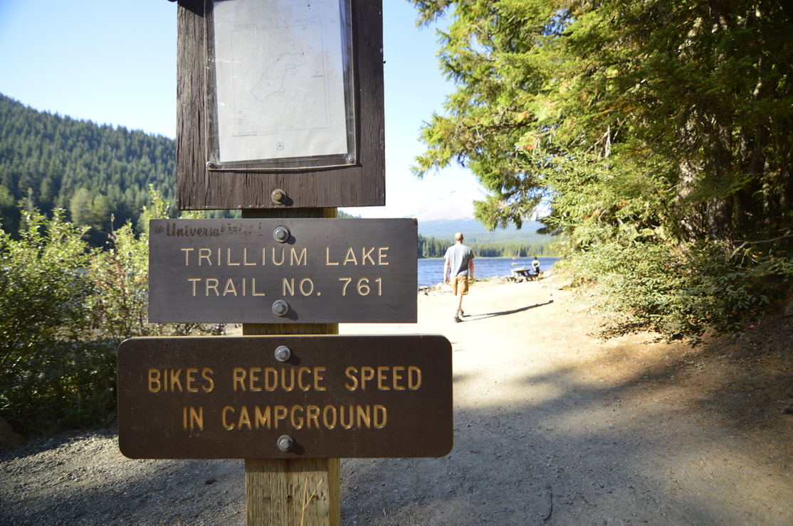
General location: 3 miles east of Government Camp off of Hwy. 26 - Mt. Hood National Forest
Accessible: Year-round
(Best time to go for hiking is after Labor Day when some of the crowds die down and the fall colors come out. For snowshoeing it's best to go during the end of December through early March).
Permits required: Annual Northwest Forest Pass or $5 day pass available at the trailhead May 1 - October 31, sno-park permit is required from November 1 - April 30 and is NOT available for purchase at the trailhead.
Pit toilet at trailhead: Yes multiple
Trail allows: Dogs on leash only, bikes, cross-country skiing/snowshoeing
Possible dangers: N/A
Approximate hike time: 52 minutes w/ an average pace of 2.3 mph if you are hiking
1 hour 45 minutes w/ an average pace of 2.3 mph if you are snowshoeing
Difficulty: Easy
Trail usage: Very high on summer and winter weekends, medium to high on weekdays
Highest elevation: 3,635 ft. Lowest elevation: 3,580 ft.
General location: 3 miles east of Government Camp off of Hwy. 26 - Mt. Hood National Forest
Accessible: Year-round
(Best time to go for hiking is after Labor Day when some of the crowds die down and the fall colors come out. For snowshoeing it's best to go during the end of December through early March).
Permits required: Annual Northwest Forest Pass or $5 day pass available at the trailhead May 1 - October 31, sno-park permit is required from November 1 - April 30 and is NOT available for purchase at the trailhead.
Pit toilet at trailhead: Yes multiple
Trail allows: Dogs on leash only, bikes, cross-country skiing/snowshoeing
Possible dangers: N/A
|
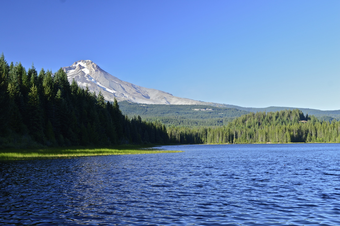
Description:Trillium Lake is a very easy and scenic 2 mile hike in a very popular area! Trillium Lake is an extremely popular place in the summer time due to its close proximity to the Portland metropolitan area. There are 3 vault toilets in the Trillium Lake Day Use Area, as well as plenty of trash cans.
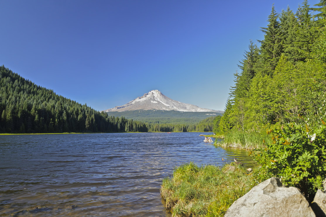
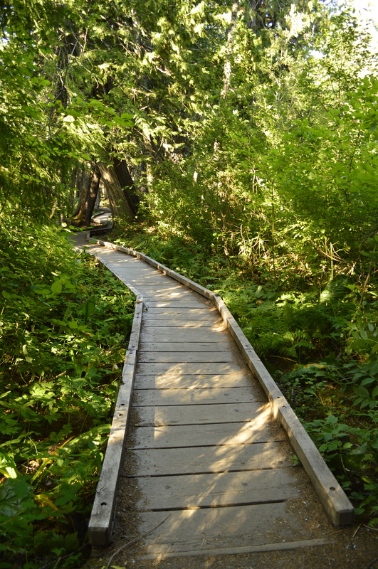
The very first view you get of the mountain across the lake, is right at the beginning of the trail. There are some small sandy beaches with picnic tables where lots of ducks like to hang out and scavenge on the scraps of food that people drop. From here the trail goes into the woods for a little while and there are wooden board walks to walk on, since some of this area can be wet and marshy. These board walks also make it easier for bikes to be able to ride around the lake. |
|
The very first view that you get of Mount Hood across the lake is right at the start of the loop trail. There are some small sandy beaches with picnic tables where lots of ducks like to hang out and scavenge on the scraps of food that people drop. From here the trail goes into the woods for a little bit and there are wooden boardwalks to walk on, since some of this area can be wet and marshy. These boardwalks also make it easier for bikes to be able to ride around the lake.
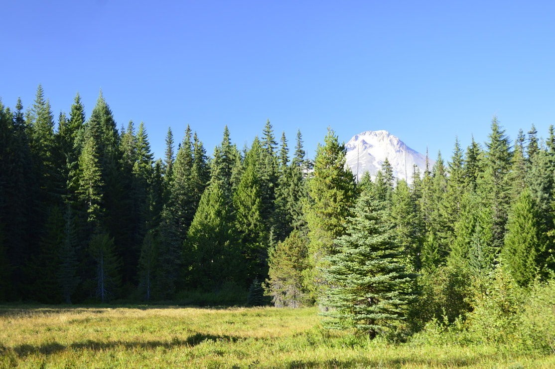
On the east side of the lake there is a campground with sites that come right up to the trail. All of these sites are very close to one another and the trees here are fairly small so there is not much privacy if you are camping here. After the trail passes the campground, it takes you around the northern end of the lake, which offers little to no views of Mount Hood, but you will see open meadows and on early summer mornings, likely some wildlife here (such as loons, heron, geese and deer). |
|
The west side of the lake takes you into some cooler darker woods with no lake access due to lots of reeds that separate the trail from the lake. Here the ducks come to nest, away from the crowds.
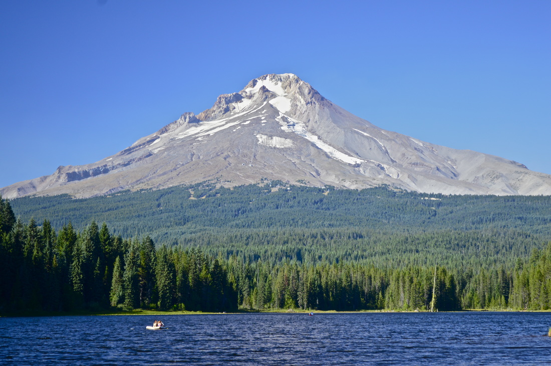
Keep in mind, dogs are allowed on the trail, but they must be on a leash! Please do not let your dog chase the ducks and other wildlife that lives by the lake. Coming around the west end of the lake and then back into the more open south end, provides you with that photogenic view of Mount Hood and the entire lake. It is spectacular, especially in the early morning and at sunset when you can sometimes catch that perfect reflection.
Keep in mind, dogs are allowed on the trail, but they must be on a leash! Please do not let your dog chase the ducks and other wildlife that lives by the lake. Coming around the west end of the lake and then back into the more open south end, provides you with that photogenic view of Mount Hood and the entire lake. It is spectacular, especially in the early morning and at sunset when you can sometimes catch that perfect reflection.
Trillium Lake was once known as Mud Lake because it was a boggy area south of Summit Meadows. In 1960 Mud Creek was dammed which increased the lake by 62 acres and was then named Trillium Lake because of the many Trillium flowers that grow in the area.
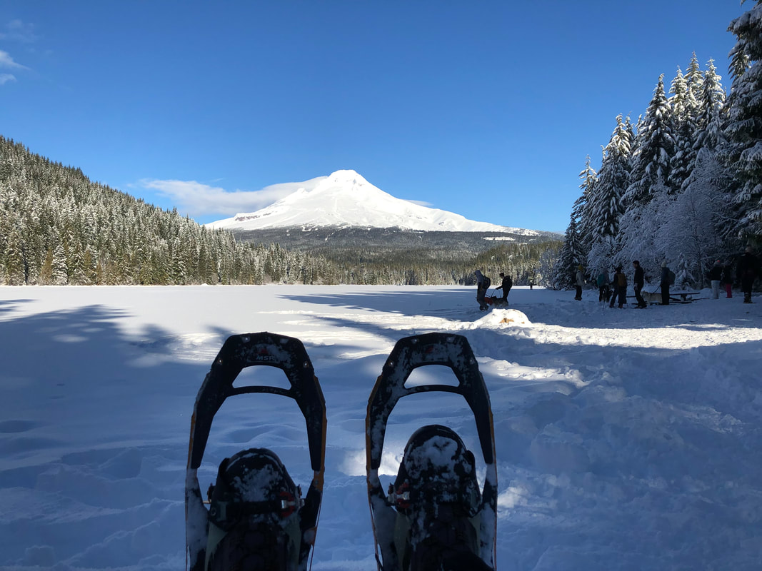
(Trillium Lake in the winter - picture by CJ Woods)
Trillium Lake Trail is a great place to hike with young kids. The trail is compact, not too dusty and very easy to walk on, especially on the boardwalk sections. It is also just an all-around nice place to enjoy the epic beauty of Oregon's nature. You can bike ride around the lake, or if you have older kids who can swim, you can easily spend all day on paddle boards or canoes on the lake. In the winter many people come here to snowshoe around the lake. They close the gate at Trillium Lake Road, so if you are snowshoeing you will park at Trillium sno-park and snowshow 2 miles down the road, and then around the lake, making the whole excursion 6 miles.
Directions:
From Portland
- Drive on US-26 for 40.4 miles to Government Camp. 3 miles past Government Camp turn right at sign for Trillium Lake. Follow signs to Trillium Lake Rd. 1.6 miles and park at the main day use area right by the lake. (Total of 60.4 miles)
- Drive on I-5 N towards Portland for 29.5 miles then use the right 2 lanes to take exit 288 for I-205 toward Oregon City. Continue on I-205 N for 11.3 miles then take exit 12 for OR-212/OR-224 E toward Estacada/Mt Hood. Stay on OR-212 for 11.5 miles, then turn right towards Sandy/Mount Hood and merge onto US-26. Stay on this road for 34.6 miles and 3 miles past Government Camp turn right at sign for Trillium Lake. Follow signs to Trillium Lake Rd. 1.6 miles and park at the main day use area right by the lake. (Total of 94.6 miles)
- Drive north on US-97 towards Madras for about 43.5 miles then merge left onto US-26 west for 60.5 miles. Then turn left at a sign for Trillium Lake. Follow signs to Trillium Lake Rd. 1.6 miles and park at the main day use area right by the lake. (Total of 107 miles)
- Drive on I-5 N towards Portland for 108 miles then use the right 2 lanes to take exit 288 for I-205 toward Oregon City. Continue on I-205 N for 11.3 miles then take exit 12 for OR-212/OR-224 E toward Estacada/Mt Hood. Stay on OR-212 for 11.5 miles, then turn right towards Sandy/Mount Hood and merge onto US-26. Stay on this road for 34.6 miles and 3 miles past Government Camp turn right at sign for Trillium Lake. Follow signs to Trillium Lake Rd. 1.6 miles and park at the main day use area right by the lake. (Total of 156 miles)
- Drive on OR-62 E for 49.5 miles, then take a slight left onto OR-230 N for another 23.8 miles. Turn right onto OR-138 E for 17.7 miles and then turn left onto US-97 for 116 miles all the way to Madras. In the town of Madras merge left onto US-26 west for 60.5 miles. Then turn left at a sign for Trillium Lake. Follow signs to Trillium Lake Rd. 1.6 miles and park at the main day use area right by the lake. (Total of 278 miles)
-This trail write-up was last updated in 2019-
*All pictures unless otherwise marked are taken by Franziska Weinheimer
*All pictures unless otherwise marked are taken by Franziska Weinheimer
*Disclaimer: The trail descriptions, mileage, GPS tracks and difficulty ratings depicted on this website are never 100% accurate. Always hike at your own risk, using your own knowledge, equipment and common sense. Franziska Weinheimer/Hike Oregon are not responsible if you or anyone in your party gets injured or lost while attempting one of these or any other hikes.