Hike Oregon
  • Home
  • *Store*
  • About the author
  • How to use this site
  • Resources
    • Wildflowers
    • Videos
  • Best Oregon Hikes
    • 20 Epic Oregon Wildflower Hikes
    • Top 10 Oregon Spring Hikes
    • 20 Best Oregon Waterfall Hikes
    • Top 10 Oregon Hikes for Kids
    • 5 Weekend Backpacking Trips in Oregon
    • Top One Night Backpacking Trips in Oregon
    • Top Fall Foliage Hikes In Oregon
    • Top 10 Oregon Summer Hikes
    • Top 10 Swimming Spots In Oregon
    • Top 10 Oregon Fall Hikes
    • Sno-Parks In Central Oregon
    • Top 10 Oregon Winter Hikes
    • Top Low Elevation Winter Hikes
  • Oregon Sno-Parks
    • Maxwell Sno-Park
    • Potato Hill Sno-Park
    • Ray Benson Sno-Park
      • Brandenburg Shelter
    • Santiam Sno-Park
    • Three Creek Sno-Park
    • Virginia Meissner Sno-Park
      • Meissner Shelter Loop
      • Nordeen Shelter
    • Gold Lake Sno-Park
      • Westview Shelter to Eagle Rock Overlook
      • Marilyn Lakes Loop
  • Portland
    • Powell Butte
    • Forest Park
    • Hamilton Mountain
    • Latourell Falls
    • Multnomah/Wahkeena Falls
    • Dog Mountain
    • Coyote Wall
    • Mitchell Point
    • Table Rock
    • Tamanawas Falls
    • Trillium Lake
    • East Zigzag Mountain (members only)
  • Salem
    • Abiqua Falls
    • Silver Falls State Park
    • Marion Lake to Marion Mountain
    • Jefferson Park
  • Sweet Home
    • Crescent Mountain
    • Iron Mountain
    • McDowell Creek Falls
    • Middle Santiam River (members only)
    • Lower Soda Creek Falls (members only)
    • Rooster Rock (members only)
  • McKenzie Bridge/Blue River
    • Macduff Mountain
    • Proxy Falls
    • Clear Lake
    • Sahalie/Koosah Falls
    • Blue Pool
    • Erma Bell Lakes
    • Olallie Mountain
    • Horsepasture Mountain
    • Tidbits Mountain
    • Castle Rock
    • East Fork Trail (members only)
    • Rainbow Falls Overlook (members only)
    • Frissell Point (members only)
    • Chucksney Mountain (members only)
    • Substitute Point (members only)
  • Sisters/Santiam Pass
    • Coffin Mountain
    • Trappers Butte and Scar Mountain
    • Black Butte
    • Tam McArthur Rim
    • Black Crater
    • Scott Mountain
    • Obsidian Trail
    • Three Fingered Jack Loop
    • Square Lake
    • Canyon Creek Meadows
    • Patjens Lakes
    • Craig Lake (members only)
    • Chush Falls (members only)
    • Rockpile Lake (members only)
    • Santiam Lake (members only)
    • Camp Lake (members only)
    • Park Meadow to Golden Lake (members only)
  • Bend/Redmond/LaPine
    • Steins Pillar
    • Chimney Rock
    • Steelhead Falls
    • Tumalo State Park
    • Tumalo Falls
    • Tumalo Mountain
    • No Name Lake
    • Green Lakes
    • Moraine Lake
    • South Sister Summit
    • Muskrat Lake
    • Paulina Peak
    • Peter Skene Ogden Trail (members only)
  • Eugene
    • Ridgeline Trail
    • Mount Pisgah Summit
    • Mount Pisgah Arboretum
    • Shotgun Creek
    • Mount June
    • Lawler
    • Tire Mountain
    • Goodman Creek
    • Brice Creek
    • Trestle Creek Falls
    • Moon Falls
    • Elijah Bristow State Park
    • South Willamette Trail (members only)
    • Eula Ridge (members only)
    • Eagle's Rest (members only)
  • Oakridge
    • Deception Creek
    • North Salmon Creek
    • Grasshopper Ridge
    • Larison Creek
    • Bunchgrass Ridge
    • Salt Creek Falls
    • Waldo Lake Loop
    • South Waldo Loop
    • The Twins
    • Rosary Lakes
    • Fawn Lake
    • Windy Lakes
    • Divide Lake
    • Diamond Peak Summit
    • Cowhorn Mountain
    • Wall Creek Warm Springs (members only)
    • Moon Point (members only)
    • Bobby Lake (members only)
    • Lillian Falls (members only)
    • Middle Fork Willamette Trail (members only)
    • Pool Creek Falls (members only)
    • Dead Mountain (members only)
    • Larison Rock (members only)
    • Eddeeleo Lakes (members only)
    • Waldo Mountain Lookout (members only)
    • Blair Lake to Mule Mountain (members only)
    • Rigdon Lakes loop (members only)
  • Oregon Coast
    • Cascade Head
    • Drift Creek Falls
    • Sweet Creek Falls
    • Alsea Falls
    • Kentucky Falls
    • Marys Peak North Ridge
    • Marys Peak East Ridge
    • Cape Perpetua Loops
    • Hobbit Trail to Heceta Head
    • North Fork Smith River (members only)
    • Cummins Ridge (member's only)
    • Horse Creek (members only)
    • Siltcoos Lake (members only)
    • William Finley Wildlife Refuge (members only)
  • Southern Oregon
    • Fall Creek Falls
    • Watson Falls
    • Wild Rogue Loop
    • Mt. Thielsen
    • The Watchman
    • Mount Scott
    • The Pinnacles
    • Lower Table Rock
    • Pilot Rock
    • Wagner Butte
    • Mt. McLoughlin
    • Lemolo Falls (members only)
    • Fern Falls (members only)
  • Eastern Oregon
    • Painted Cove
    • Mount Howard
    • Anthony Lake Loop
    • Schneider Cabin (members only)
    • Strawberry Lake & Falls (members only)
  • Oregon PCT sections
    • PCT: OR-58 to Charlton Lake
    • PCT: Santiam Pass to Rockpile Lake
  • Tips & Tricks
    • Leave No Trace
    • Top Tips For Hiking With Infants And Toddlers
    • Poison Oak, Ivy and Sumac
    • How to dress for cold weather hikes
    • Hiker Holiday Gift Guide 2019
    • Outdoor Holiday Gift Guide 2018
    • Hiking Holiday Gift Guide 2017
  • Reviews
    • Outdoor Herbivore Backpacking Food Review
    • Osprey Aura AG 65 Backpack review
    • Big Agnes Fly Creek UL2 review
    • REI Quarter Dome 1 review
  • Adventure Stories
    • Hiking The Rae Lakes Loop
    • 110 Miles on the PCT
    • The Loop Around Three Fingered Jack
    • Jefferson Wilderness

The Watchman

The Watchman trail map
Get the printable version of this hike

Hike Details:

Mileage: 1.6 miles out and back w/ 375 ft. elevation gain
Approximate hike time: 41 minutes w/ an average pace of 2.3 mph
Difficulty: Easy
Trail usage: High during the summer months July through mid-September
General location: 82 miles northeast of Medford - Crater Lake National Park
Suggested seasons: Summer, fall
(Best time to go is mid-September and early October when there are less people in the park but the weather is still amazing).
Permits required: 
  • America The Beautiful Pass or Annual Crater Lake Pass
  • Day pass: cars - $30 in the summer (May 22-October 31), $20 in the winter (November 1-May 21). Admits one private, non-commercial vehicle (15-passenger capacity or less) and all occupants. Good for 7 days.
  • Motorcycles - $25 in the summer (May 22-October 31), $15 in the winter (November 1-May 21). Admits one or two passengers on a private, non-commercial motorcycle. Good for 7 days.
  • Bicycles & Pedestrians - $15 per individual. Admits one individual with no car (bicyclist, hiker, pedestrian). Youth 15 and under are admitted free of charge. Good for 7 days.
Pit toilet at trailhead: Yes
Trail allows: ​NO DOGS!!!
Possible dangers: Afternoon thunderstorms in July and August
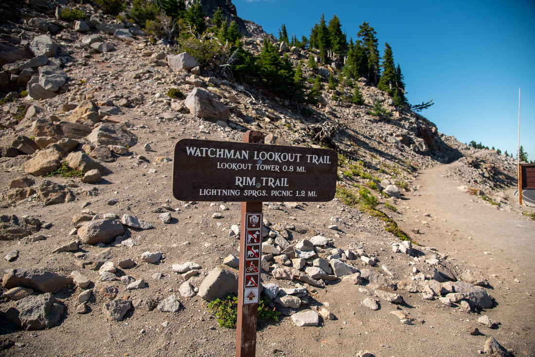
The Watchman Trail sign
(trailhead sign)

Description:

The Watchman is an easy hike located within Crater Lake National Park that takes you up to an incredible lake rim viewpoint. From the top you can see the whole lake and the mountains beyond!
The trailhead is large and there is also a lake rim viewing area there, so most people who are parked in the parking lot are just going to the viewing area and not actually hiking to the top of The Watchman. The trail starts at the southern end of the parking area and this section is also part of the Crater Lake Rim Trail. Keep in mind, dogs are NOT allowed on this trail!
the beginning of The Watchman Trail
Crater Lake Rim Trail sign
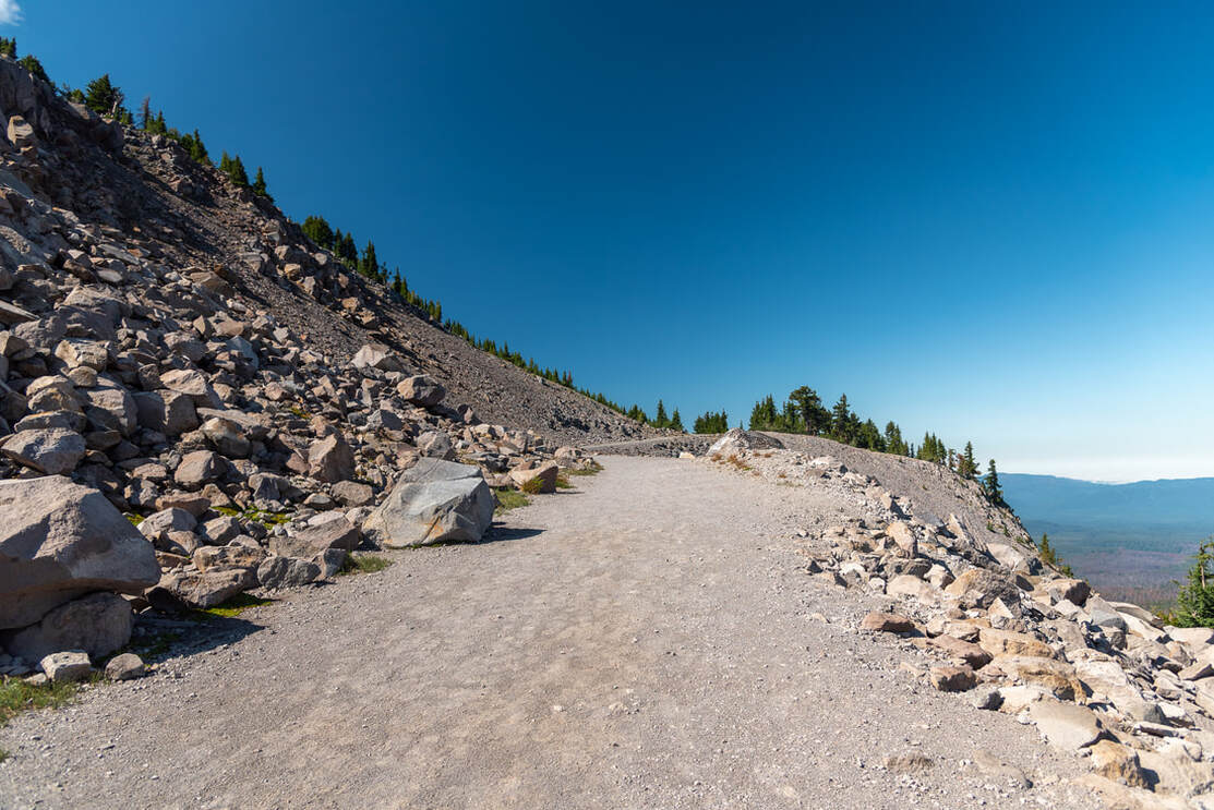
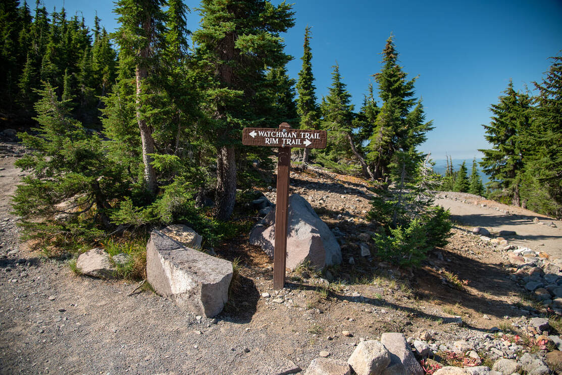
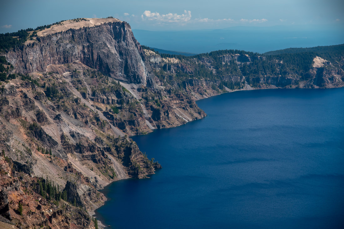
The first part of the trail is a very wide gravel path where you will likely see that some rocks have tumbled down from the hillside on the left. At the 0.3 mile mark you will come to a trail split. Here the Rim Trail continues to the right and you will continue to the left on the Watchman Trail. Over the next 0.5 miles you will go up 9 switchbacks. From the trail you will start getting great views to the north, west and south. 
view of Hillman Peak Crater Lake National Park
(view of Hillman Peak, Mount Bailey, Diamond Peak and Mt. Thielsen)
view of Crater Lake from the watchman
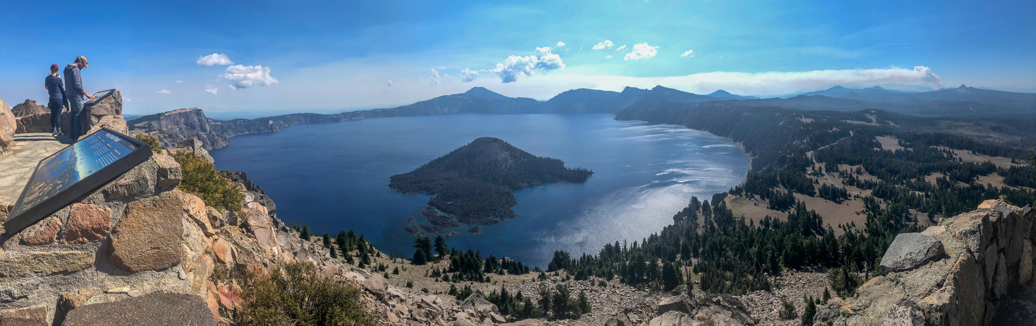
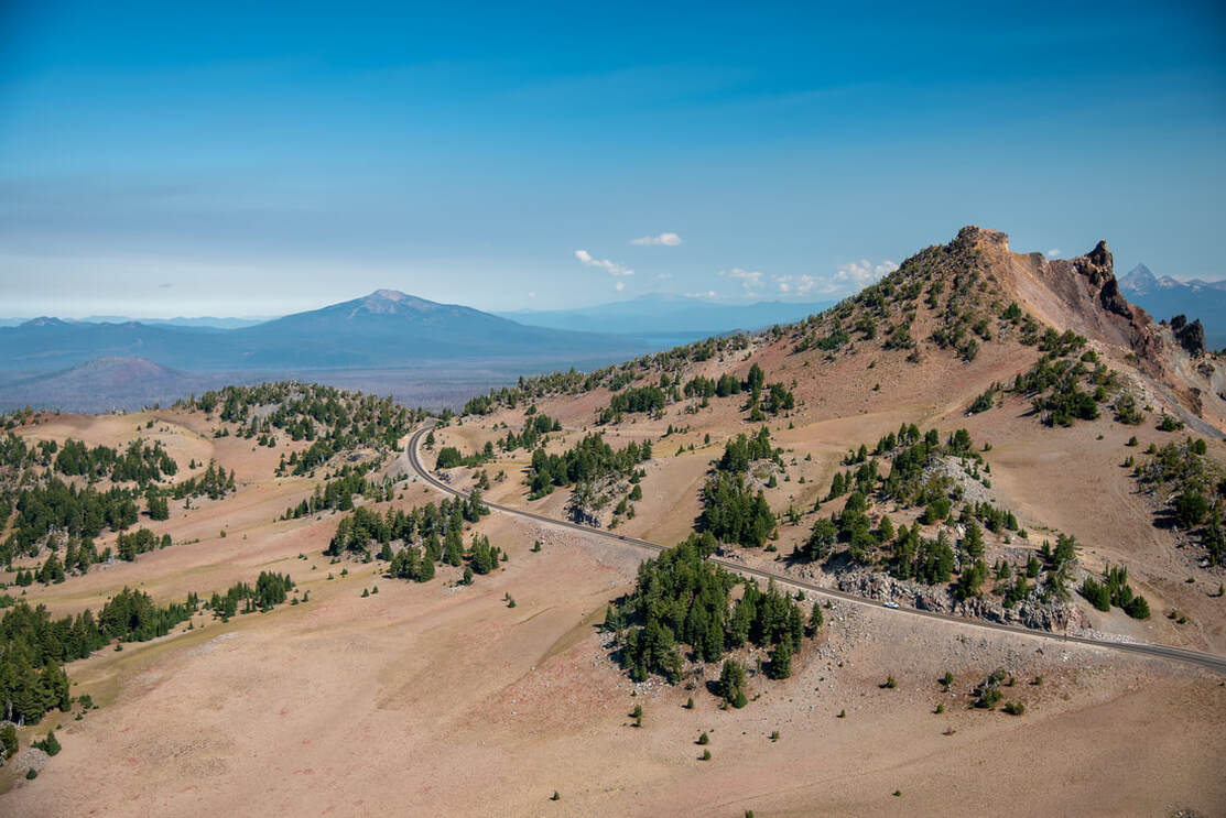
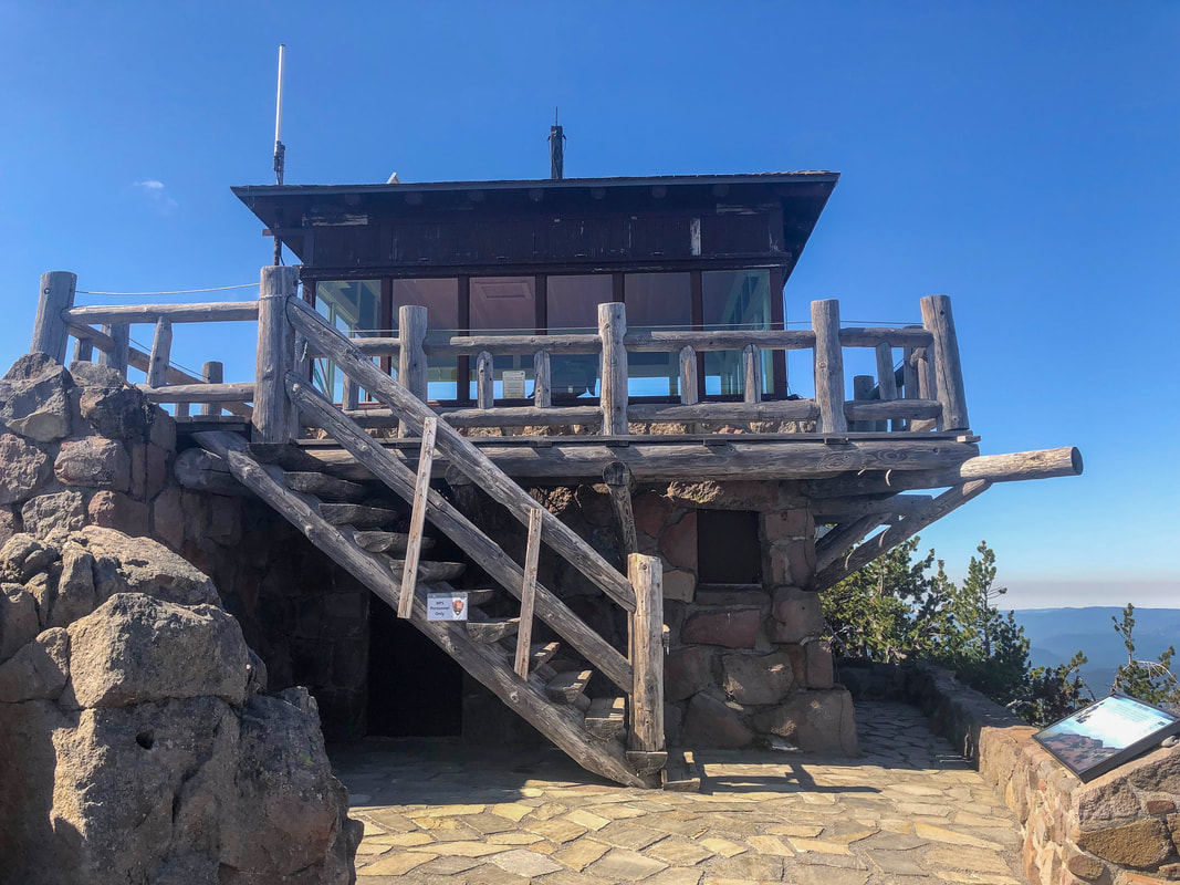
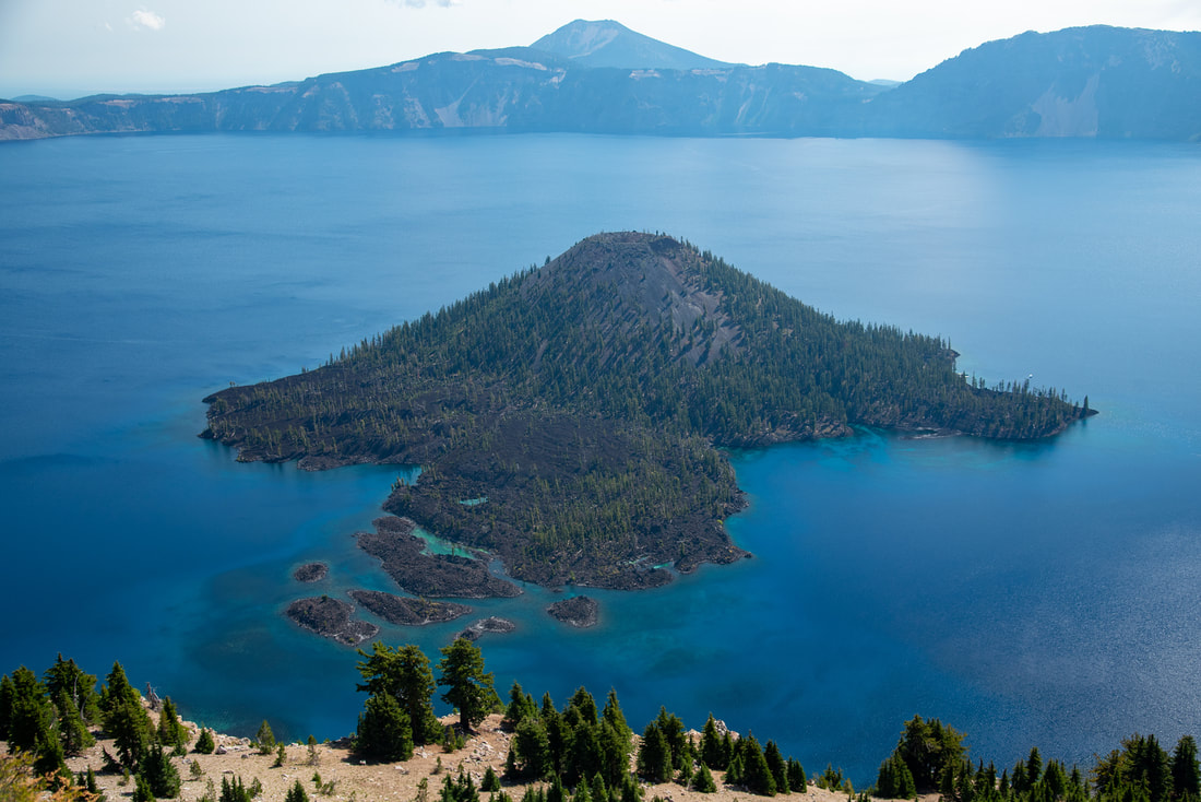
At the summit of The Watchman there is an old fire lookout and a very well made stone viewing platform with information plaques. The walls are about 3 feet high so it isn't too dangerous to be up there, however if you have small kids, please keep an eye on them. We all know kids love to climb, and the drop off on the other side of the wall is very steep and rocky! From the summit to the north you will see Hillman Peak closest to The Watchman, then Mount Bailey, Mt. Thielsen and Diamond Peak (all of these are also amazing viewpoint hikes). Across the incredibly blue Crater Lake you will see Mount Scott and Garfield Peak, and to the south you will see Mt. McLoughlin and on a very clear day even Mt. Shasta is visible. Being on this side of Wizard Island allows you to see the many coves of the island and the amazing tropical looking water.  
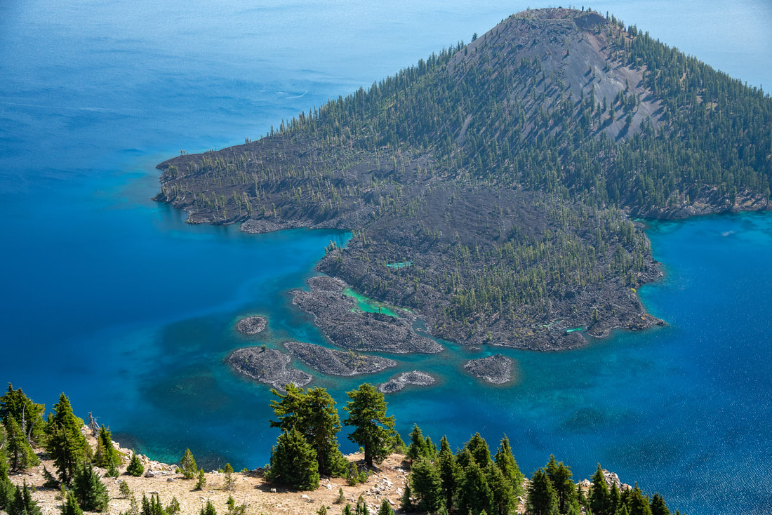
Crater Lake Rim from The Watchman
The Watchman Lookout
Wizard Island Crater Lake National Park
(Wizard Island)
Overall, The Watchman is a must-do short and easy hike during your visit to Crater Lake National Park. It is family friendly, and the trail is a mixture of gravel and dirt. There are no big rocky or rooted sections and because the trail is inside the national park, it gets regular maintenance. This hike is not safe to do during the winter when there is snow, and also keep in mind that the Crater Lake area is known for summer afternoon thunderstorms, so watch the weather before climbing up to The Watchman. Worst case scenario you can huddle underneath the fire lookout, but it is not a good idea to be stuck out on the trail when there is lightning as this is a high point along the rim. 
Crater Lake Wizard Island view from The Watchman

Directions:

From Medford
  • Drive OR-62 E for a total of 49.5 miles, then at a fork turn right to stay on OR-62 E for another 15.8 miles. Turn left onto Munson Valley Rd/Volcanic Legacy Scenic Byway for 6.7 miles, then turn left onto Rim Dr/Volcanic Legacy Scenic Byway for 3.7 miles and find the trailhead on your right. (Total of 82 miles)
From Bend
  • Drive US-97 S for a total of 74.5 miles, then turn right onto OR-138 W for 14.7 miles. At a sign for Crater Lake North Entrance turn left onto Crater Lake Hwy N/Volcanic Legacy Scenic Byway for 11.3 miles and find the trailhead on your left. (Total of 101 miles)
From Eugene
  • Drive OR-58 E for a total of 86.2 miles, then merge onto US-97 S and stay on US-97 for 17.9 miles. Turn right onto OR-138 W for 14.7 miles. At a sign for Crater Lake North Entrance turn left onto Crater Lake Hwy N/Volcanic Legacy Scenic Byway for 11.3 miles and find the trailhead on your left. (Total of 138 miles)
From Salem
  • Total of 199 miles via Eugene.
From Portland
  • Total of 243 miles via Eugene.
*All pictures are taken by Franziska Weinheimer
*Disclaimer: The trail descriptions, mileage, GPS tracks and difficulty ratings depicted on this website are never 100% accurate. Always hike at your own risk, using your own knowledge, equipment and common sense. 
Franziska Weinheimer/Hike Oregon are not responsible if you or anyone in your party gets injured or lost while attempting one of these or any other hikes.

HIKED HERE RECENTLY?! PLEASE LEAVE A TRIP REPORT BELOW:

© Hike Oregon 2022
P.O. Box 41911
​Eugene, OR 97404
Proudly powered by Weebly
  • Home
  • *Store*
  • About the author
  • How to use this site
  • Resources
    • Wildflowers
    • Videos
  • Best Oregon Hikes
    • 20 Epic Oregon Wildflower Hikes
    • Top 10 Oregon Spring Hikes
    • 20 Best Oregon Waterfall Hikes
    • Top 10 Oregon Hikes for Kids
    • 5 Weekend Backpacking Trips in Oregon
    • Top One Night Backpacking Trips in Oregon
    • Top Fall Foliage Hikes In Oregon
    • Top 10 Oregon Summer Hikes
    • Top 10 Swimming Spots In Oregon
    • Top 10 Oregon Fall Hikes
    • Sno-Parks In Central Oregon
    • Top 10 Oregon Winter Hikes
    • Top Low Elevation Winter Hikes
  • Oregon Sno-Parks
    • Maxwell Sno-Park
    • Potato Hill Sno-Park
    • Ray Benson Sno-Park
      • Brandenburg Shelter
    • Santiam Sno-Park
    • Three Creek Sno-Park
    • Virginia Meissner Sno-Park
      • Meissner Shelter Loop
      • Nordeen Shelter
    • Gold Lake Sno-Park
      • Westview Shelter to Eagle Rock Overlook
      • Marilyn Lakes Loop
  • Portland
    • Powell Butte
    • Forest Park
    • Hamilton Mountain
    • Latourell Falls
    • Multnomah/Wahkeena Falls
    • Dog Mountain
    • Coyote Wall
    • Mitchell Point
    • Table Rock
    • Tamanawas Falls
    • Trillium Lake
    • East Zigzag Mountain (members only)
  • Salem
    • Abiqua Falls
    • Silver Falls State Park
    • Marion Lake to Marion Mountain
    • Jefferson Park
  • Sweet Home
    • Crescent Mountain
    • Iron Mountain
    • McDowell Creek Falls
    • Middle Santiam River (members only)
    • Lower Soda Creek Falls (members only)
    • Rooster Rock (members only)
  • McKenzie Bridge/Blue River
    • Macduff Mountain
    • Proxy Falls
    • Clear Lake
    • Sahalie/Koosah Falls
    • Blue Pool
    • Erma Bell Lakes
    • Olallie Mountain
    • Horsepasture Mountain
    • Tidbits Mountain
    • Castle Rock
    • East Fork Trail (members only)
    • Rainbow Falls Overlook (members only)
    • Frissell Point (members only)
    • Chucksney Mountain (members only)
    • Substitute Point (members only)
  • Sisters/Santiam Pass
    • Coffin Mountain
    • Trappers Butte and Scar Mountain
    • Black Butte
    • Tam McArthur Rim
    • Black Crater
    • Scott Mountain
    • Obsidian Trail
    • Three Fingered Jack Loop
    • Square Lake
    • Canyon Creek Meadows
    • Patjens Lakes
    • Craig Lake (members only)
    • Chush Falls (members only)
    • Rockpile Lake (members only)
    • Santiam Lake (members only)
    • Camp Lake (members only)
    • Park Meadow to Golden Lake (members only)
  • Bend/Redmond/LaPine
    • Steins Pillar
    • Chimney Rock
    • Steelhead Falls
    • Tumalo State Park
    • Tumalo Falls
    • Tumalo Mountain
    • No Name Lake
    • Green Lakes
    • Moraine Lake
    • South Sister Summit
    • Muskrat Lake
    • Paulina Peak
    • Peter Skene Ogden Trail (members only)
  • Eugene
    • Ridgeline Trail
    • Mount Pisgah Summit
    • Mount Pisgah Arboretum
    • Shotgun Creek
    • Mount June
    • Lawler
    • Tire Mountain
    • Goodman Creek
    • Brice Creek
    • Trestle Creek Falls
    • Moon Falls
    • Elijah Bristow State Park
    • South Willamette Trail (members only)
    • Eula Ridge (members only)
    • Eagle's Rest (members only)
  • Oakridge
    • Deception Creek
    • North Salmon Creek
    • Grasshopper Ridge
    • Larison Creek
    • Bunchgrass Ridge
    • Salt Creek Falls
    • Waldo Lake Loop
    • South Waldo Loop
    • The Twins
    • Rosary Lakes
    • Fawn Lake
    • Windy Lakes
    • Divide Lake
    • Diamond Peak Summit
    • Cowhorn Mountain
    • Wall Creek Warm Springs (members only)
    • Moon Point (members only)
    • Bobby Lake (members only)
    • Lillian Falls (members only)
    • Middle Fork Willamette Trail (members only)
    • Pool Creek Falls (members only)
    • Dead Mountain (members only)
    • Larison Rock (members only)
    • Eddeeleo Lakes (members only)
    • Waldo Mountain Lookout (members only)
    • Blair Lake to Mule Mountain (members only)
    • Rigdon Lakes loop (members only)
  • Oregon Coast
    • Cascade Head
    • Drift Creek Falls
    • Sweet Creek Falls
    • Alsea Falls
    • Kentucky Falls
    • Marys Peak North Ridge
    • Marys Peak East Ridge
    • Cape Perpetua Loops
    • Hobbit Trail to Heceta Head
    • North Fork Smith River (members only)
    • Cummins Ridge (member's only)
    • Horse Creek (members only)
    • Siltcoos Lake (members only)
    • William Finley Wildlife Refuge (members only)
  • Southern Oregon
    • Fall Creek Falls
    • Watson Falls
    • Wild Rogue Loop
    • Mt. Thielsen
    • The Watchman
    • Mount Scott
    • The Pinnacles
    • Lower Table Rock
    • Pilot Rock
    • Wagner Butte
    • Mt. McLoughlin
    • Lemolo Falls (members only)
    • Fern Falls (members only)
  • Eastern Oregon
    • Painted Cove
    • Mount Howard
    • Anthony Lake Loop
    • Schneider Cabin (members only)
    • Strawberry Lake & Falls (members only)
  • Oregon PCT sections
    • PCT: OR-58 to Charlton Lake
    • PCT: Santiam Pass to Rockpile Lake
  • Tips & Tricks
    • Leave No Trace
    • Top Tips For Hiking With Infants And Toddlers
    • Poison Oak, Ivy and Sumac
    • How to dress for cold weather hikes
    • Hiker Holiday Gift Guide 2019
    • Outdoor Holiday Gift Guide 2018
    • Hiking Holiday Gift Guide 2017
  • Reviews
    • Outdoor Herbivore Backpacking Food Review
    • Osprey Aura AG 65 Backpack review
    • Big Agnes Fly Creek UL2 review
    • REI Quarter Dome 1 review
  • Adventure Stories
    • Hiking The Rae Lakes Loop
    • 110 Miles on the PCT
    • The Loop Around Three Fingered Jack
    • Jefferson Wilderness