Hike Oregon
  • Home
  • *Store*
  • About the author
  • How to use this site
  • Resources
    • Wildflowers
    • Videos
  • Best Oregon Hikes
    • Top 10 Oregon Fall Hikes
    • Underrated Fall Foliage Hikes In Oregon
    • 20 Best Oregon Waterfall Hikes
    • Top One Night Backpacking Trips in Oregon
    • 5 Weekend Backpacking Trips in Oregon
    • 9 Amazing Oregon Summit Hikes
    • Top 10 Oregon Hikes for Kids
    • Sno-Parks In Central Oregon
    • Top 10 Oregon Winter Hikes
    • Top Low Elevation Winter Hikes
    • Top 10 Oregon Spring Hikes
    • 20 Epic Oregon Wildflower Hikes
    • Top 10 Oregon Summer Hikes
    • 20 Central Oregon Day Hikes
    • Top 10 Swimming Spots In Oregon
  • Oregon Sno-Parks
    • Maxwell Sno-Park
    • Potato Hill Sno-Park
    • Ray Benson Sno-Park
      • Brandenburg Shelter
    • Santiam Sno-Park
    • Three Creek Sno-Park
    • Virginia Meissner Sno-Park
      • Meissner Shelter Loop
      • Nordeen Shelter
    • Gold Lake Sno-Park
      • Westview Shelter to Eagle Rock Overlook
      • Marilyn Lakes Loop
  • Southern Washington
    • Hamilton Mountain
    • Dog Mountain
    • Coyote Wall
    • Mount St. Helens
  • Portland
    • Powell Butte
    • Forest Park
    • Latourell Falls
    • Multnomah/Wahkeena Falls
    • Eagle Creek
    • Mitchell Point
    • Table Rock
    • Tamanawas Falls
    • Trillium Lake
    • East Zigzag Mountain (members only)
  • Salem
    • Abiqua Falls
    • Silver Falls State Park
    • Dome Rock
    • Marion Lake to Marion Mountain
    • Jefferson Park
  • Corvallis
    • William Finley Wildlife Refuge
      • Campbell Boardwalk
      • Woodpecker Loop
      • Mill Hill Loop
      • Beaver Pond Loop
    • Marys Peak East Ridge
    • Marys Peak North Ridge
    • Alsea Falls and Green Peak Falls
    • Corvallis to Sea Trail - Sugarbowl Creek segment (members only)
  • Sweet Home
    • Crescent Mountain
    • Iron Mountain
    • McDowell Creek Falls
    • Middle Santiam River (members only)
    • Lower Soda Creek Falls (members only)
    • Rooster Rock (members only)
  • McKenzie Bridge/Blue River
    • Macduff Mountain
    • Proxy Falls
    • Clear Lake
    • Sahalie/Koosah Falls
    • Blue Pool
    • Erma Bell Lakes
    • Olallie Mountain
    • Horsepasture Mountain
    • Tidbits Mountain
    • Castle Rock
    • Separation Lake (members only)
    • Lowder Mountain (members only)
    • East Fork Trail (members only)
    • Rainbow Falls Overlook (members only)
    • Frissell Point (members only)
    • Chucksney Mountain (members only)
    • Substitute Point (members only)
  • Sisters/Santiam Pass
    • Coffin Mountain
    • Trappers Butte and Scar Mountain
    • Maxwell Butte
    • Black Butte
    • Whychus Creek Trail
    • Tam McArthur Rim
    • Black Crater
    • Scott Mountain
    • Obsidian Trail
    • Metolius Preserve
    • Three Fingered Jack Loop
    • Square Lake
    • Canyon Creek Meadows
    • Patjens Lakes
    • Craig Lake (members only)
    • Chush Falls (members only)
    • Rockpile Lake (members only)
    • Santiam Lake (members only)
    • Camp Lake (members only)
    • Park Meadow to Golden Lake (members only)
  • Bend/Redmond/LaPine
    • Steins Pillar
    • Chimney Rock
    • Steelhead Falls
    • Tumalo State Park
    • Shevlin Park Loop
    • Tumalo Falls
    • Tumalo Mountain
    • No Name Lake
    • Green Lakes
    • Moraine Lake
    • South Sister Summit
    • Horse Lake
    • Muskrat Lake
    • Paulina Peak
    • The Badlands - Flatiron Rock Trail
    • Peter Skene Ogden Trail (members only)
  • Eugene
    • Ridgeline Trail
    • Mount Pisgah Summit
    • Mount Pisgah Arboretum
    • Shotgun Creek
    • Mount June
    • Lawler
    • Tire Mountain
    • Hardesty Mountain
    • Goodman Creek
    • Brice Creek
    • Trestle Creek Falls
    • Parker Falls
    • Moon Falls
    • Elijah Bristow State Park
    • South Willamette Trail (members only)
    • Eula Ridge (members only)
    • Eagle's Rest (members only)
  • Oakridge
    • Deception Creek
    • North Salmon Creek
    • Grasshopper Ridge
    • Larison Creek
    • Bunchgrass Ridge
    • Salt Creek Falls
    • Waldo Lake Loop
    • South Waldo Loop
    • The Twins
    • Rosary Lakes
    • Yoran Lake
    • Fawn Lake
    • Windy Lakes
    • Divide Lake
    • Diamond Peak Summit
    • Cowhorn Mountain
    • Wall Creek Warm Springs (members only)
    • Moon Point (members only)
    • Bobby Lake (members only)
    • Lillian Falls (members only)
    • Middle Fork Willamette Trail (members only)
    • Pool Creek Falls (members only)
    • Dead Mountain (members only)
    • Larison Rock (members only)
    • Quinn Lakes & Eddeeleo Lakes (members only)
    • Waldo Mountain Lookout (members only)
    • Blair Lake to Spring Prairie (members only)
    • Rigdon Lakes loop (members only)
  • Oregon Coast
    • Cascade Head
    • Drift Creek Falls
    • Sweet Creek Falls
    • Beaver Creek Falls
    • Kentucky Falls
    • Hobbit Trail to Heceta Head
    • Valley Trail to China Creek
    • Sutton Creek Trail (members only)
    • North Fork Smith River (members only)
    • Cummins Ridge (member's only)
    • Horse Creek (members only)
    • Siltcoos Lake (members only)
  • Southern Oregon
    • Fall Creek Falls
    • Watson Falls
    • Wild Rogue Loop
    • Mt. Thielsen
    • Crater Lake National Park
      • The Watchman
      • Mount Scott
      • The Pinnacles
    • Lower Table Rock
    • Pilot Rock
    • Wagner Butte
    • Mt. McLoughlin
    • Lemolo Falls (members only)
    • Fern Falls (members only)
  • Eastern Oregon
    • Painted Cove
    • Anthony Lake Loop
    • Mount Howard
    • Eagle Cap summit
    • Schneider Cabin (members only)
    • Strawberry Lake & Strawberry Falls (members only)
  • Northern California
    • Taylor & Hogan Lake (members only)
  • Oregon PCT sections
    • PCT: CA border to Callahan's
  • Tips & Tricks
    • Leave No Trace
    • How Much Water To Carry When Backpacking
    • Storing Your Bear Canister When Backpacking
    • How To Pick The Right Backpacking Tent
    • Top Tips For Hiking With Infants And Toddlers
    • Poison Oak, Ivy and Sumac
    • How to dress for cold weather hikes
  • Reviews and Gear
    • Hiking Pants and Leggings
    • Jackets for Hiking and Backpacking
    • Long Sleeved Shirts For Cold Weather Hiking
    • Stay Kühl This Summer
    • Outdoor Herbivore Backpacking Food Review
    • Osprey Aura AG 65 Backpack review
    • Big Agnes Fly Creek UL2 review
    • REI Quarter Dome 1 review
    • Outdoorsy Holiday Gift Guide 2022
    • Hiker Holiday Gift Guide 2019
    • Outdoor Holiday Gift Guide 2018
    • Hiking Holiday Gift Guide 2017
  • Adventure Stories
    • Hiking The Rae Lakes Loop
    • 110 Miles on the PCT
    • Three Fingered Jack Adventures
    • Jefferson Wilderness

Drift Creek Falls

​
Get the printable version of this hike

Hike details:

Mileage: 3 miles out and back w/ 525 ft. elevation gain
Approximate hike time: 1 hour 18 minutes w/ an average pace of 2.3 mph
Difficulty: Easy
Trail usage: Medium to high on weekends, (low to medium trail usage especially in the late fall and winter and on week days)
​
Highest elevation: 1,915 ft. Lowest elevation: 635 ft.
General location: 16 miles east of Lincoln City - Siuslaw National Forest
Accessible: Year-round
(Best time to go is December through April for best waterfall flow and lush greenery).
Permits required: Northwest Forest Pass for parking
Pit toilet at trailhead: Yes
Trail allows: Dogs on leash
Possible dangers: ​N/A
Drift Creek Falls parking lot
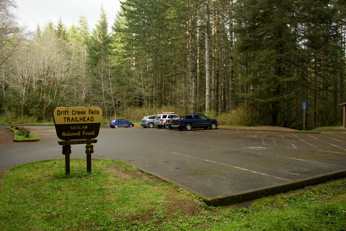
(parking lot picture taken by Jonathan Stull)

Description:

Drift Creek Falls is an easy 3 mile round-trip hike that is perfect for the whole family! This hike is generally accessible year-round and because of its relatively close proximity to Portland and Salem, it does tend to be busy on weekends. The parking lot is quite small for how popular this hike is, and it can hold roughly 20 cars. There is a pit toilet at the trailhead and to help keep the trailhead clean and stocked with toilet paper and map brochures, you are required to pay a $5 day use fee, or us your Annual NW Forest Pass if you have one. 
Drift Creek Falls trail sign
Drift Creek Falls Trail
Suspension bridge at Drift Creek Falls
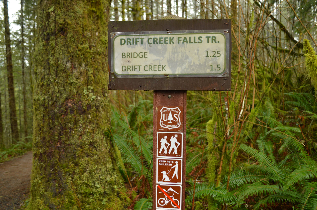
Please read the sign at the beginning of the hike that lets you know of the mileage as well as the trail rules such as no bicycles and all dogs must be kept on a leash at all times!
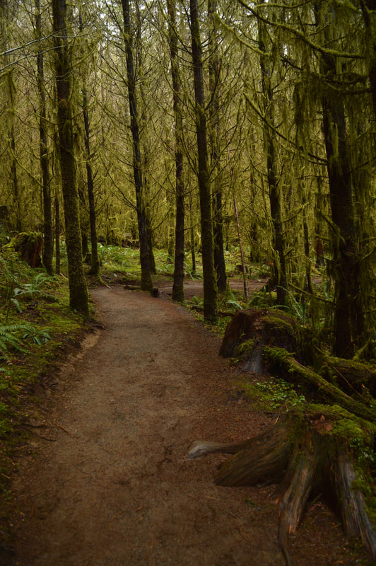
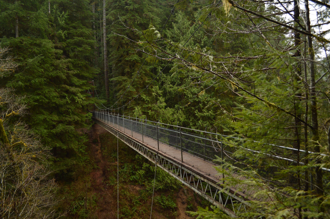
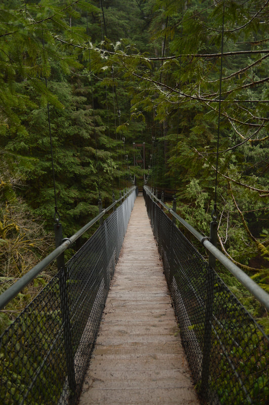
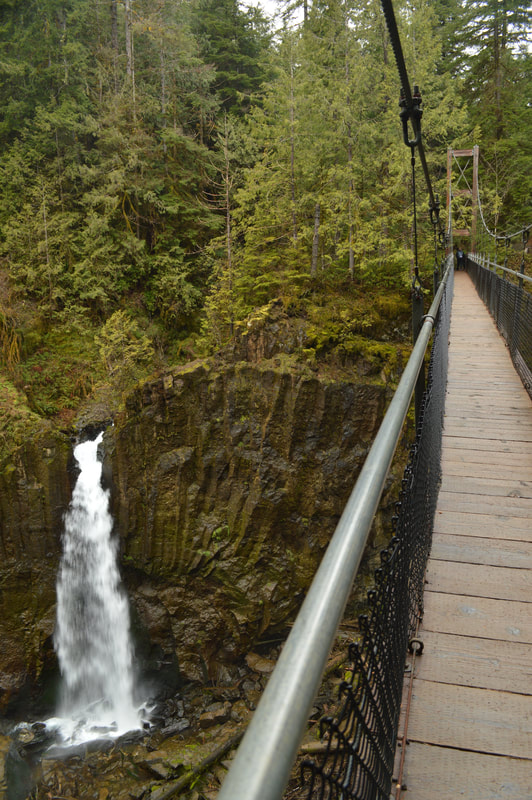
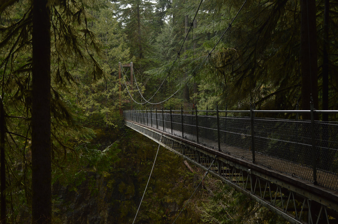
This is one of the rare trails that loses elevation going to the destination. You will not have any elevation gain until you're on your way back to the car. The trail is very wide and well groomed, and it meanders through a lush forest of moss covered trees and thick fern undergrowth. 
About a mile into the hike you will come across a beautiful suspension bridge that hangs 100 feet off the ground and spans a total of 240 feet to the other side of the canyon. It was built in 1997 and all the parts were flown in by a helicopter and it can support 165,000 pounds, so don't worry...even though it sways and moves a bit when you walk across, it will not collapse. The bridge is one of the coolest part of the hike.

Drift Creek Falls suspension bridge
Drift Creek Falls from the suspension bridge
Drift Creek
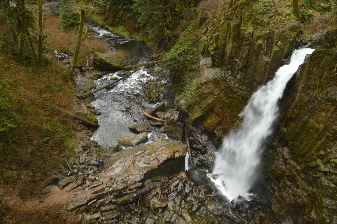
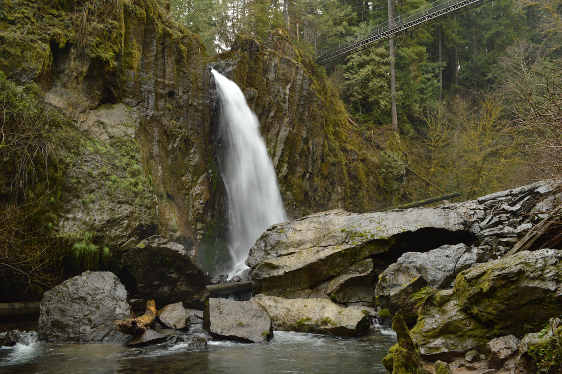
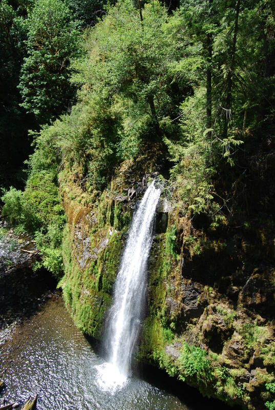
After walking across the bridge, the trail has a few switchbacks as you head down to the base of Drift Creek Falls. This waterfall used to look quite different actually. In 2010 a huge rock face broke away, revealing beautiful columnar basalt, giving it the iconic look that it has today. Unfortunately the rocks that broke off, fell into the beautiful pool that was once at the base of this waterfall. 
Drift Creek Falls and suspension bridge
Drift Creek Falls is 66 feet tall and now plummets down onto a pile of huge rocks. It may be tempting to walk around on these rocks, however it is not recommended as they are always wet due to the spray from the falls and are covered in slippery moss. 

Overall, this hike is very easy, however keep in mind that you will be gaining all of the 500+ feet of elevation on the way back. The thrill of the suspension bridge and the roaring falls in the canyon, make for quite the adventure. This is the perfect hike to take children on because the trail is wide so you can hold their hand, and it is well groomed and there are no drop off dangers until you get to the bridge. The Siuslaw National Forest is brimming with greenery and shows off the quintessential Oregon forest. 
Drift Creek Falls prior to 2010
(Drift Creek Falls prior to the rock face collapse - picture taken by Crystal Sola)
Drift Creek Falls suspension bridge in winter

Directions​:

From Lincoln City
  • Take Hwy. 101 south for 3.4 miles then turn left onto S. Drift Creek Road and stay on this road for 1.6 miles. When the road comes to a T turn right to stay on S. Drift Creek Road for only .4 miles then take a slight left onto S. Drift Creek Camp Road where you will pass Drift Creek County Park then continue on for .9 miles. You will see a fork in the road, stay left on NF-17 and continue on for 9.3 windy miles until you reach the trailhead on your right.  (Total of 15.8 miles)
From Salem
  • Drive OR-22 west towards Lincoln City for 16.4 miles then take the ramp to the Oregon Coast merging onto OR-18 west. Stay on this road for 21.8 miles then turn left onto N. Bear Creek Road which turns into NF-17. Continue on this windy road for 8.9 miles until you get to the trailhead on your right. (Total of 57.4 miles)
From Portland
  • Drive I-5 south then merge onto OR-99W S/SW Barbur Blvd/Pacific Hwy W for 5 miles, then keep right to stay on OR-99 W for another 17.3 miles. Just past Bellevue continue on OR-18. Stay on this road for 21.8 miles then turn left onto N. Bear Creek Road which turns into NF-17. Continue on this windy road for 8.9 miles until you get to the trailhead on your right. (Total of 86.2 miles).
From Eugene
  • Total of 123 miles via Salem.
From Bend
  • Total of 190 miles via Salem.
From Medford
  • Total of 286 miles via Salem.
-This trail write-up was last updated June, 2022-
​*All pictures unless otherwise marked are taken by Franziska Weinheimer
​*Disclaimer: The trail descriptions, mileage, GPS tracks and difficulty ratings depicted on this website are never 100% accurate. Always hike at your own risk, using your own knowledge, equipment and common sense. Franziska Weinheimer/Hike Oregon are not responsible if you or anyone in your party gets injured or lost while attempting one of these or any other hikes. ​​​

HIKED HERE RECENTLY? PLEASE LEAVE A TRIP REPORT BELOW:

© Hike Oregon 2023
P.O. Box 41911
​Eugene, OR 97404
Proudly powered by Weebly
  • Home
  • *Store*
  • About the author
  • How to use this site
  • Resources
    • Wildflowers
    • Videos
  • Best Oregon Hikes
    • Top 10 Oregon Fall Hikes
    • Underrated Fall Foliage Hikes In Oregon
    • 20 Best Oregon Waterfall Hikes
    • Top One Night Backpacking Trips in Oregon
    • 5 Weekend Backpacking Trips in Oregon
    • 9 Amazing Oregon Summit Hikes
    • Top 10 Oregon Hikes for Kids
    • Sno-Parks In Central Oregon
    • Top 10 Oregon Winter Hikes
    • Top Low Elevation Winter Hikes
    • Top 10 Oregon Spring Hikes
    • 20 Epic Oregon Wildflower Hikes
    • Top 10 Oregon Summer Hikes
    • 20 Central Oregon Day Hikes
    • Top 10 Swimming Spots In Oregon
  • Oregon Sno-Parks
    • Maxwell Sno-Park
    • Potato Hill Sno-Park
    • Ray Benson Sno-Park
      • Brandenburg Shelter
    • Santiam Sno-Park
    • Three Creek Sno-Park
    • Virginia Meissner Sno-Park
      • Meissner Shelter Loop
      • Nordeen Shelter
    • Gold Lake Sno-Park
      • Westview Shelter to Eagle Rock Overlook
      • Marilyn Lakes Loop
  • Southern Washington
    • Hamilton Mountain
    • Dog Mountain
    • Coyote Wall
    • Mount St. Helens
  • Portland
    • Powell Butte
    • Forest Park
    • Latourell Falls
    • Multnomah/Wahkeena Falls
    • Eagle Creek
    • Mitchell Point
    • Table Rock
    • Tamanawas Falls
    • Trillium Lake
    • East Zigzag Mountain (members only)
  • Salem
    • Abiqua Falls
    • Silver Falls State Park
    • Dome Rock
    • Marion Lake to Marion Mountain
    • Jefferson Park
  • Corvallis
    • William Finley Wildlife Refuge
      • Campbell Boardwalk
      • Woodpecker Loop
      • Mill Hill Loop
      • Beaver Pond Loop
    • Marys Peak East Ridge
    • Marys Peak North Ridge
    • Alsea Falls and Green Peak Falls
    • Corvallis to Sea Trail - Sugarbowl Creek segment (members only)
  • Sweet Home
    • Crescent Mountain
    • Iron Mountain
    • McDowell Creek Falls
    • Middle Santiam River (members only)
    • Lower Soda Creek Falls (members only)
    • Rooster Rock (members only)
  • McKenzie Bridge/Blue River
    • Macduff Mountain
    • Proxy Falls
    • Clear Lake
    • Sahalie/Koosah Falls
    • Blue Pool
    • Erma Bell Lakes
    • Olallie Mountain
    • Horsepasture Mountain
    • Tidbits Mountain
    • Castle Rock
    • Separation Lake (members only)
    • Lowder Mountain (members only)
    • East Fork Trail (members only)
    • Rainbow Falls Overlook (members only)
    • Frissell Point (members only)
    • Chucksney Mountain (members only)
    • Substitute Point (members only)
  • Sisters/Santiam Pass
    • Coffin Mountain
    • Trappers Butte and Scar Mountain
    • Maxwell Butte
    • Black Butte
    • Whychus Creek Trail
    • Tam McArthur Rim
    • Black Crater
    • Scott Mountain
    • Obsidian Trail
    • Metolius Preserve
    • Three Fingered Jack Loop
    • Square Lake
    • Canyon Creek Meadows
    • Patjens Lakes
    • Craig Lake (members only)
    • Chush Falls (members only)
    • Rockpile Lake (members only)
    • Santiam Lake (members only)
    • Camp Lake (members only)
    • Park Meadow to Golden Lake (members only)
  • Bend/Redmond/LaPine
    • Steins Pillar
    • Chimney Rock
    • Steelhead Falls
    • Tumalo State Park
    • Shevlin Park Loop
    • Tumalo Falls
    • Tumalo Mountain
    • No Name Lake
    • Green Lakes
    • Moraine Lake
    • South Sister Summit
    • Horse Lake
    • Muskrat Lake
    • Paulina Peak
    • The Badlands - Flatiron Rock Trail
    • Peter Skene Ogden Trail (members only)
  • Eugene
    • Ridgeline Trail
    • Mount Pisgah Summit
    • Mount Pisgah Arboretum
    • Shotgun Creek
    • Mount June
    • Lawler
    • Tire Mountain
    • Hardesty Mountain
    • Goodman Creek
    • Brice Creek
    • Trestle Creek Falls
    • Parker Falls
    • Moon Falls
    • Elijah Bristow State Park
    • South Willamette Trail (members only)
    • Eula Ridge (members only)
    • Eagle's Rest (members only)
  • Oakridge
    • Deception Creek
    • North Salmon Creek
    • Grasshopper Ridge
    • Larison Creek
    • Bunchgrass Ridge
    • Salt Creek Falls
    • Waldo Lake Loop
    • South Waldo Loop
    • The Twins
    • Rosary Lakes
    • Yoran Lake
    • Fawn Lake
    • Windy Lakes
    • Divide Lake
    • Diamond Peak Summit
    • Cowhorn Mountain
    • Wall Creek Warm Springs (members only)
    • Moon Point (members only)
    • Bobby Lake (members only)
    • Lillian Falls (members only)
    • Middle Fork Willamette Trail (members only)
    • Pool Creek Falls (members only)
    • Dead Mountain (members only)
    • Larison Rock (members only)
    • Quinn Lakes & Eddeeleo Lakes (members only)
    • Waldo Mountain Lookout (members only)
    • Blair Lake to Spring Prairie (members only)
    • Rigdon Lakes loop (members only)
  • Oregon Coast
    • Cascade Head
    • Drift Creek Falls
    • Sweet Creek Falls
    • Beaver Creek Falls
    • Kentucky Falls
    • Hobbit Trail to Heceta Head
    • Valley Trail to China Creek
    • Sutton Creek Trail (members only)
    • North Fork Smith River (members only)
    • Cummins Ridge (member's only)
    • Horse Creek (members only)
    • Siltcoos Lake (members only)
  • Southern Oregon
    • Fall Creek Falls
    • Watson Falls
    • Wild Rogue Loop
    • Mt. Thielsen
    • Crater Lake National Park
      • The Watchman
      • Mount Scott
      • The Pinnacles
    • Lower Table Rock
    • Pilot Rock
    • Wagner Butte
    • Mt. McLoughlin
    • Lemolo Falls (members only)
    • Fern Falls (members only)
  • Eastern Oregon
    • Painted Cove
    • Anthony Lake Loop
    • Mount Howard
    • Eagle Cap summit
    • Schneider Cabin (members only)
    • Strawberry Lake & Strawberry Falls (members only)
  • Northern California
    • Taylor & Hogan Lake (members only)
  • Oregon PCT sections
    • PCT: CA border to Callahan's
  • Tips & Tricks
    • Leave No Trace
    • How Much Water To Carry When Backpacking
    • Storing Your Bear Canister When Backpacking
    • How To Pick The Right Backpacking Tent
    • Top Tips For Hiking With Infants And Toddlers
    • Poison Oak, Ivy and Sumac
    • How to dress for cold weather hikes
  • Reviews and Gear
    • Hiking Pants and Leggings
    • Jackets for Hiking and Backpacking
    • Long Sleeved Shirts For Cold Weather Hiking
    • Stay Kühl This Summer
    • Outdoor Herbivore Backpacking Food Review
    • Osprey Aura AG 65 Backpack review
    • Big Agnes Fly Creek UL2 review
    • REI Quarter Dome 1 review
    • Outdoorsy Holiday Gift Guide 2022
    • Hiker Holiday Gift Guide 2019
    • Outdoor Holiday Gift Guide 2018
    • Hiking Holiday Gift Guide 2017
  • Adventure Stories
    • Hiking The Rae Lakes Loop
    • 110 Miles on the PCT
    • Three Fingered Jack Adventures
    • Jefferson Wilderness