Hike Oregon
  • Home
  • *Store*
  • About the author
  • How to use this site
  • Resources
    • Wildflowers
    • Videos
  • Best Oregon Hikes
    • Top 10 Oregon Spring Hikes
    • 20 Epic Oregon Wildflower Hikes
    • 20 Best Oregon Waterfall Hikes
    • Top 10 Swimming Spots In Oregon
    • Top 10 Oregon Summer Hikes
    • 20 Central Oregon Day Hikes
    • Top One Night Backpacking Trips in Oregon
    • 5 Weekend Backpacking Trips in Oregon
    • 9 Amazing Oregon Summit Hikes
    • Top Fall Foliage Hikes In Oregon
    • Top 10 Oregon Fall Hikes
    • Top 10 Oregon Hikes for Kids
    • Sno-Parks In Central Oregon
    • Top 10 Oregon Winter Hikes
    • Top Low Elevation Winter Hikes
  • Oregon Sno-Parks
    • Maxwell Sno-Park
    • Potato Hill Sno-Park
    • Ray Benson Sno-Park
      • Brandenburg Shelter
    • Santiam Sno-Park
    • Three Creek Sno-Park
    • Virginia Meissner Sno-Park
      • Meissner Shelter Loop
      • Nordeen Shelter
    • Gold Lake Sno-Park
      • Westview Shelter to Eagle Rock Overlook
      • Marilyn Lakes Loop
  • Southern Washington
    • Hamilton Mountain
    • Dog Mountain
    • Coyote Wall
    • Mount St. Helens
  • Portland
    • Powell Butte
    • Forest Park
    • Latourell Falls
    • Multnomah/Wahkeena Falls
    • Eagle Creek
    • Mitchell Point
    • Table Rock
    • Tamanawas Falls
    • Trillium Lake
    • East Zigzag Mountain (members only)
  • Salem
    • Abiqua Falls
    • Silver Falls State Park
    • Dome Rock
    • Marion Lake to Marion Mountain
    • Jefferson Park
  • Corvallis
    • William Finley Wildlife Refuge
      • Campbell Boardwalk
      • Woodpecker Loop
      • Mill Hill Loop
      • Beaver Pond Loop
    • Marys Peak East Ridge
    • Marys Peak North Ridge
    • Alsea Falls and Green Peak Falls
    • Corvallis to Sea Trail - Sugarbowl Creek segment (members only)
  • Sweet Home
    • Crescent Mountain
    • Iron Mountain
    • McDowell Creek Falls
    • Middle Santiam River (members only)
    • Lower Soda Creek Falls (members only)
    • Rooster Rock (members only)
  • McKenzie Bridge/Blue River
    • Macduff Mountain
    • Proxy Falls
    • Clear Lake
    • Sahalie/Koosah Falls
    • Blue Pool
    • Erma Bell Lakes
    • Olallie Mountain
    • Horsepasture Mountain
    • Tidbits Mountain
    • Castle Rock
    • Separation Lake (members only)
    • Lowder Mountain (members only)
    • East Fork Trail (members only)
    • Rainbow Falls Overlook (members only)
    • Frissell Point (members only)
    • Chucksney Mountain (members only)
    • Substitute Point (members only)
  • Sisters/Santiam Pass
    • Coffin Mountain
    • Trappers Butte and Scar Mountain
    • Maxwell Butte
    • Black Butte
    • Whychus Creek Trail
    • Tam McArthur Rim
    • Black Crater
    • Scott Mountain
    • Obsidian Trail
    • Metolius Preserve
    • Three Fingered Jack Loop
    • Square Lake
    • Canyon Creek Meadows
    • Patjens Lakes
    • Craig Lake (members only)
    • Chush Falls (members only)
    • Rockpile Lake (members only)
    • Santiam Lake (members only)
    • Camp Lake (members only)
    • Park Meadow to Golden Lake (members only)
  • Bend/Redmond/LaPine
    • Steins Pillar
    • Chimney Rock
    • Steelhead Falls
    • Tumalo State Park
    • Shevlin Park Loop
    • Tumalo Falls
    • Tumalo Mountain
    • No Name Lake
    • Green Lakes
    • Moraine Lake
    • South Sister Summit
    • Horse Lake
    • Muskrat Lake
    • Paulina Peak
    • The Badlands - Flatiron Rock Trail
    • Peter Skene Ogden Trail (members only)
  • Eugene
    • Ridgeline Trail
    • Mount Pisgah Summit
    • Mount Pisgah Arboretum
    • Shotgun Creek
    • Mount June
    • Lawler
    • Tire Mountain
    • Hardesty Mountain
    • Goodman Creek
    • Brice Creek
    • Trestle Creek Falls
    • Parker Falls
    • Moon Falls
    • Elijah Bristow State Park
    • South Willamette Trail (members only)
    • Eula Ridge (members only)
    • Eagle's Rest (members only)
  • Oakridge
    • Deception Creek
    • North Salmon Creek
    • Grasshopper Ridge
    • Larison Creek
    • Bunchgrass Ridge
    • Salt Creek Falls
    • Waldo Lake Loop
    • South Waldo Loop
    • The Twins
    • Rosary Lakes
    • Yoran Lake
    • Fawn Lake
    • Windy Lakes
    • Divide Lake
    • Diamond Peak Summit
    • Cowhorn Mountain
    • Wall Creek Warm Springs (members only)
    • Moon Point (members only)
    • Bobby Lake (members only)
    • Lillian Falls (members only)
    • Middle Fork Willamette Trail (members only)
    • Pool Creek Falls (members only)
    • Dead Mountain (members only)
    • Larison Rock (members only)
    • Quinn Lakes & Eddeeleo Lakes (members only)
    • Waldo Mountain Lookout (members only)
    • Blair Lake to Spring Prairie (members only)
    • Rigdon Lakes loop (members only)
  • Oregon Coast
    • Cascade Head
    • Drift Creek Falls
    • Sweet Creek Falls
    • Beaver Creek Falls
    • Kentucky Falls
    • Hobbit Trail to Heceta Head
    • Valley Trail to China Creek
    • Sutton Creek Trail (members only)
    • North Fork Smith River (members only)
    • Cummins Ridge (member's only)
    • Horse Creek (members only)
    • Siltcoos Lake (members only)
  • Southern Oregon
    • Fall Creek Falls
    • Watson Falls
    • Wild Rogue Loop
    • Mt. Thielsen
    • Crater Lake National Park
      • The Watchman
      • Mount Scott
      • The Pinnacles
    • Lower Table Rock
    • Pilot Rock
    • Wagner Butte
    • Mt. McLoughlin
    • Lemolo Falls (members only)
    • Fern Falls (members only)
  • Eastern Oregon
    • Painted Cove
    • Anthony Lake Loop
    • Mount Howard
    • Eagle Cap summit
    • Schneider Cabin (members only)
    • Strawberry Lake & Strawberry Falls (members only)
  • Oregon PCT sections
  • Tips & Tricks
    • Leave No Trace
    • How Much Water To Carry When Backpacking
    • Storing Your Bear Canister When Backpacking
    • How To Pick The Right Backpacking Tent
    • Top Tips For Hiking With Infants And Toddlers
    • Poison Oak, Ivy and Sumac
    • How to dress for cold weather hikes
  • Reviews and Gear
    • Hiking Pants and Leggings
    • Jackets for Hiking and Backpacking
    • Long Sleeved Shirts For Cold Weather Hiking
    • Stay Kühl This Summer
    • Outdoor Herbivore Backpacking Food Review
    • Osprey Aura AG 65 Backpack review
    • Big Agnes Fly Creek UL2 review
    • REI Quarter Dome 1 review
    • Outdoorsy Holiday Gift Guide 2022
    • Hiker Holiday Gift Guide 2019
    • Outdoor Holiday Gift Guide 2018
    • Hiking Holiday Gift Guide 2017
  • Adventure Stories
    • Hiking The Rae Lakes Loop
    • 110 Miles on the PCT
    • Three Fingered Jack Adventures
    • Jefferson Wilderness

Brice Creek

​
Get the printable version of this hike

Hike details:

​Mileage: 7.8 round trip w/ 1,390 ft. elevation gain (to Lund Park Forest Camp)
10.5 miles round trip w/ 1,900 ft. elevation gain (full trail without Trestle Creek Falls side trips)
Approximate hike time: 3 hours 23 minutes w/ an average pace of 2.3 mph (to Lund Park Forest Camp)
4 hours 33 minutes w/ an average pace of 2.3 mph (full trail without Trestle Creek Falls side trips)
Difficulty: Moderate to difficult
Trail usage: Low to medium until you get to the Trestle Creek part of the hike
Highest elevation: 2,050 ft. Lowest elevation: 1,430 ft.
General location: 23 miles south of Cottage Grove - Umpqua National Forest
Accessible: Year-round
(Best time to go is end of September through October for prime fall foliage).
Permits required: N/A
Pit toilet at trailhead: Yes
Trail allows: Dogs, mountain bikes
Possible dangers: ​N/A
Brice Creek Trail sign

Description:

The Brice Creek trail is a beautiful hike that follows the creek for a total of 5.25 miles each way. If you want to see the whole trail but only hike one way you could take two cars and park one at the lower parking lot and one at Champion Creek trailhead. You can also camp in the area and break this hike up into two days by hiking to Lund Park Campground and back to the parking lot, making it a 7.8 mile hike, and the second day hiking the Trestle Creek Falls Loop, which would then complete the entire Brice Creek Trail.
Fall leaves Brice Creek Trail
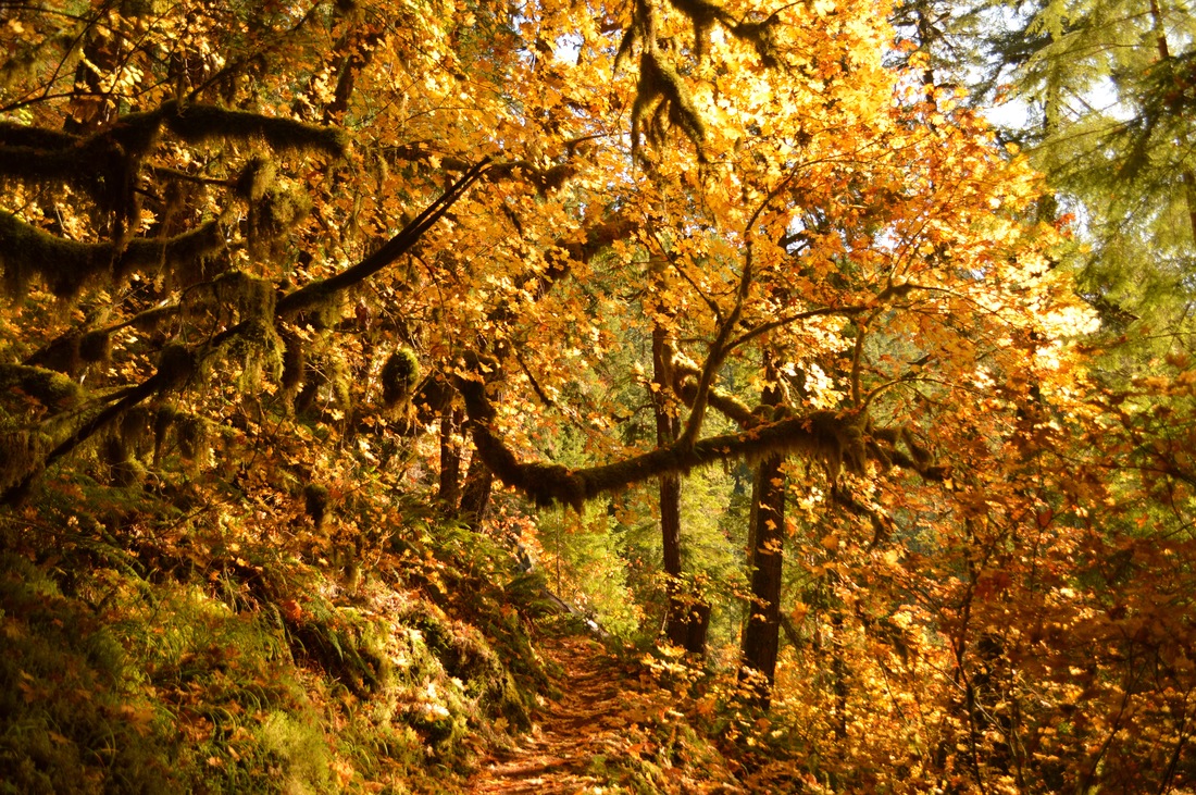
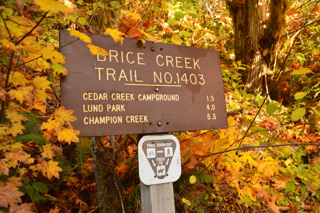
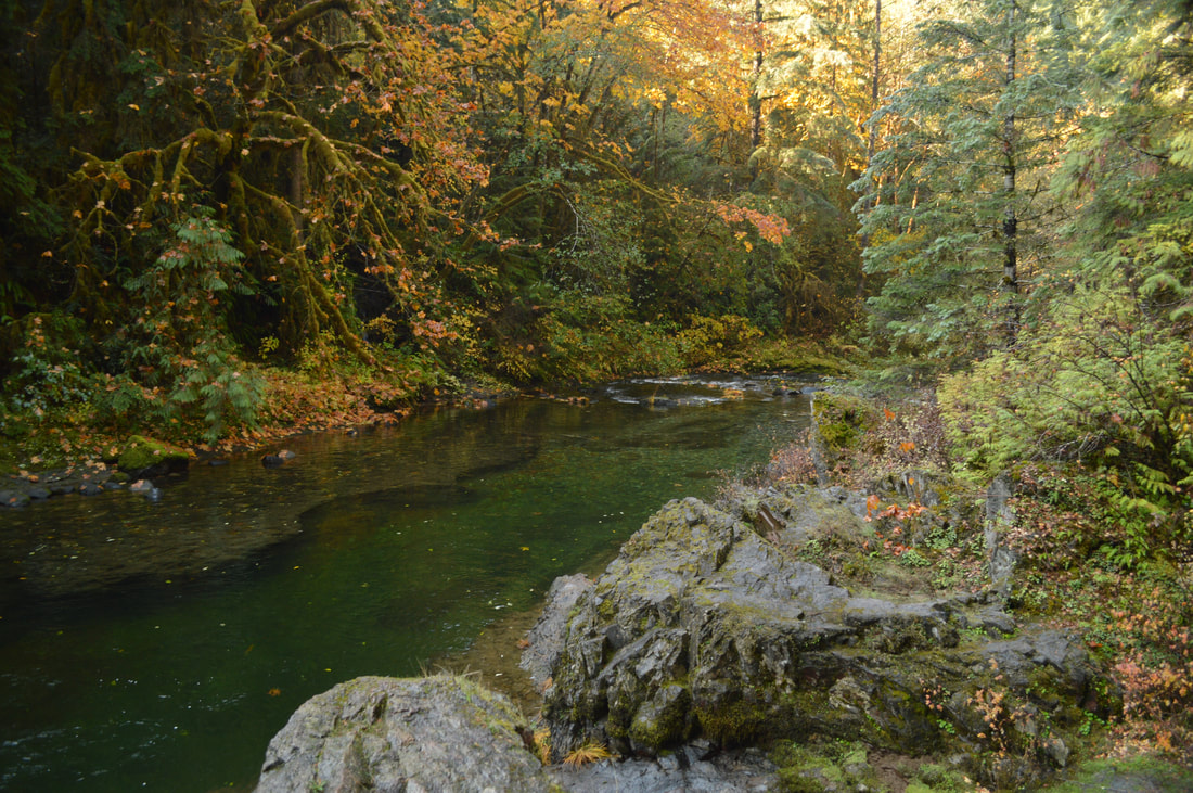
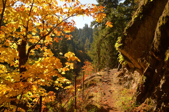
The parking area for the trail is on the right side of the road and the trail starts on the left. You will see a sign that has the mileages on it and at this point you can decide how far you want to go. The first part of the trail is fairly dry and in the fall the big leaf maples glow yellow and orange in the sunlight. The further you hike, the deeper you will get into the more typical Oregon woods that are green and lush with ferns, moss and oxalis. 
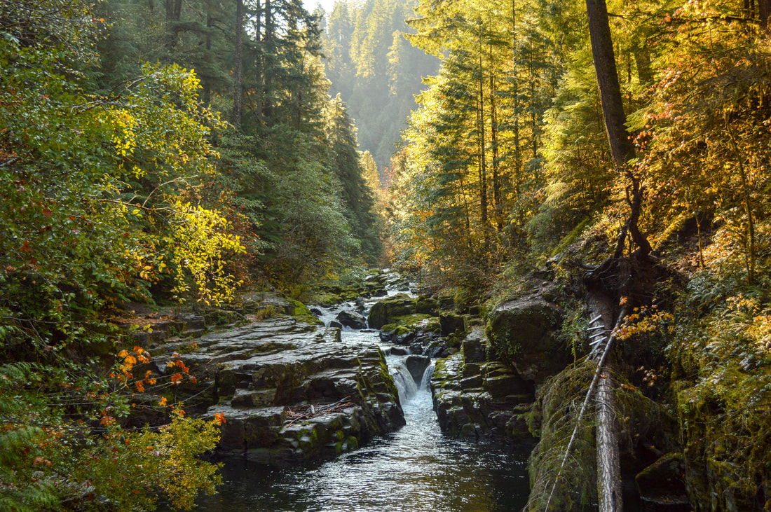
Brice Creek Brice Creek Trail
Waterfall at Brice Creek Brice Creek Trail
(Brice Creek Falls)
After 1.75 miles you will see flat rocks in the river that you can go out onto when the water is low enough. There is a lovely little 8 foot waterfall here which plunges into one of the best swimming holes along this creek. In the summer Brice Creek is extremely popular with campers who are enjoying the cool forest and people who come out for the day to swim in the creek. However, in the fall and winter Brice Creek Trail is visited much less, even on weekends, and becomes a haven for those seeking a beautiful hike not too far from Eugene. This trail is mountain bike friendly, so you might see some bikers riding past.
Brice Creek swimming hole
Bridge to Lund Park Campground
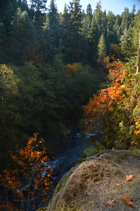
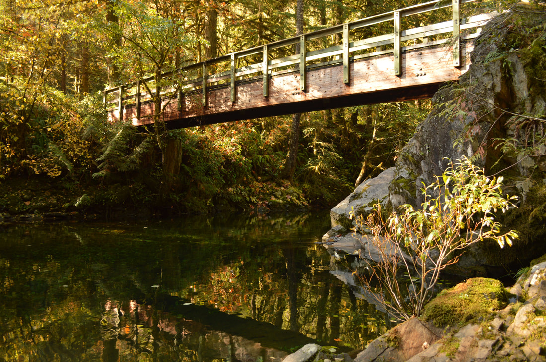
About 1.1 miles past the waterfall the trail climbs a bit and you get a great view of the trees and creek from the top. Then the trail traverses back down to a very beautiful wooden bridge that crosses the creek over to Lund Park Campground. Lund Park was named after Alex Lundgren and Tom Parker who owned an inn which stood at that spot back in the 19th century when the Bohemia Mines were operational nearby. This is a great campground with 10 spots, 2 vault toilets and garbage. Note, there is no potable water at the campground so you must bring a water filter or bring your own water when camping.
Brice Creek Trail terrain
Once you have checked out Lund Park Campground and used the restroom, you will cross the bridge again to get back to Brice Creek Trail. Here you can decide if you want to continue the 1.3 miles through the woods to the end of the trail and then turn around, or if you’re camping in the area you can break this up into two hikes and turn around here making it 7.8 miles round trip and you can do the rest of the Brice Creek Trail the next day when you hike the Trestle Creek Falls Loop, a lovely 3.75 mile loop featuring two amazing waterfalls.
The Brice Creek is a very beautiful and relatively easy hike. There is only one spot where there is some exposure on the trail, however it is very minimal and the terrain is not loose or rocky. Because there are three access points to the trail, you can break it up and make it the perfect length for the whole family. Whether you’re checking out Brice Creek in the spring, summer, fall or winter, you are sure to enjoy this trail!
Brice Creek Trail trail quality
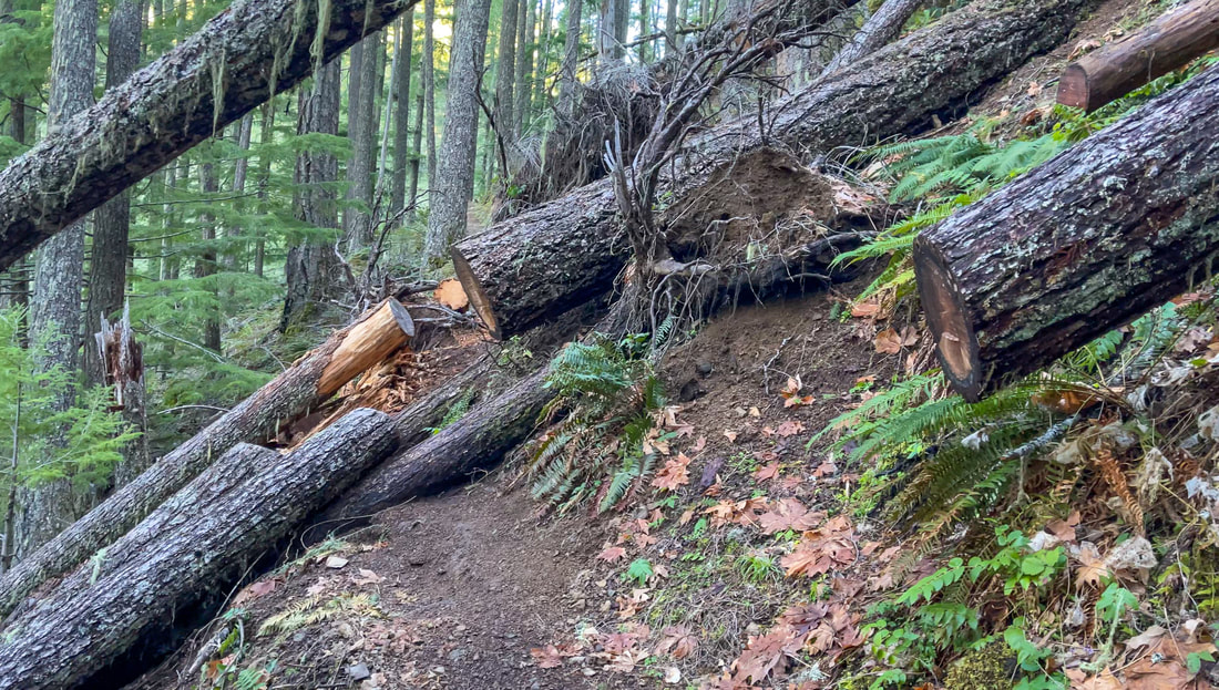
(in 2019 there was a really bad winter storm that really damaged this forest and trail. This trail has mostly been repaired since then but you can still see some damage).

Directions:

From Eugene 
  • Drive Interstate 5 south to Cottage Grove. Take exit 174 and follow signs to Dorena Lake. Continue on the main paved road NF-22 through the towns of Culp Creek and Disston (these communities are so tiny you don't even realize you are driving through a town) a total of 21.7 miles from the freeway. About a mile past the Umpqua National Forest entrance sign,  look for a trail sign on the left marking the lower Brice Creek trailhead and park in the parking lot on your right. (Total of 43.4 miles)
​From Salem
  • Drive Interstate 5 south 78.9 miles to Cottage Grove. Take exit 174 and follow signs to Dorena Lake. Continue on the main paved road NF-22 through the towns of Culp Creek and Disston (these communities are so tiny you don't even realize you are driving through a town) a total of 21.7 miles from the freeway. About a mile past the Umpqua National Forest entrance sign,  look for a trail sign on the left marking the lower Brice Creek trailhead and park in the parking lot on your right. (Total of 105 miles)
From Bend
  • Drive US-97 south 46.9 miles then turn right onto Crescent Road/Crescent Cutoff Road and continue for 12 miles until you T into OR-58. Take a right and drive OR-58 for 35.6 miles. At a sign for Hills Creek Reservoir turn left and then turn right onto Road 21 and almost right away turn left onto NF-21 for 5.7 miles. Turn right onto NF-2110 for 10.2 miles then continue straight on NF-22 for 0.6 miles then stay right on NF-22 for 3.4 miles. Turn right onto NF-22 and stay on this road for 8.1 miles until you see the parking for the Brice Creek trailhead on your left. (Total of 124 miles)
From Portland
  • Drive Interstate 5 south 125 miles to Cottage Grove. Take exit 174 and follow signs to Dorena Lake. Continue on the main paved road NF-22 through the towns of Culp Creek and Disston (these communities are so tiny you don't even realize you are driving through a town) a total of 21.7 miles from the freeway. About a mile past the Umpqua National Forest entrance sign,  look for a trail sign on the left marking the lower Brice Creek trailhead and park in the parking lot on your right. (Total of 148 miles)
From Medford
  • Drive Interstate 5 north 145 miles to Cottage Grove. Take exit 174 and follow signs to Dorena Lake. Continue on the main paved road NF-22 through the towns of Culp Creek and Disston (these communities are so tiny you don't even realize you are driving through a town) a total of 21.7 miles from the freeway. About a mile past the Umpqua National Forest entrance sign,  look for a trail sign on the left marking the lower Brice Creek trailhead and park in the parking lot on your right. (Total of 170 miles)
To get a more in-depth and personal view of this hike, watch the YouTube video.
*All pictures are taken by Franziska Weinheimer
*Disclaimer: The trail descriptions, mileage, GPS tracks and difficulty ratings depicted on this website are never 100% accurate. Always hike at your own risk, using your own knowledge, equipment and common sense. Franziska Weinheimer/Hike Oregon are not responsible if you or anyone in your party gets injured or lost while attempting one of these or any other hikes. ​

HIKED HERE RECENTLY? PLEASE LEAVE A TRIP REPORT BELOW:

© Hike Oregon 2023
P.O. Box 41911
​Eugene, OR 97404
Proudly powered by Weebly
  • Home
  • *Store*
  • About the author
  • How to use this site
  • Resources
    • Wildflowers
    • Videos
  • Best Oregon Hikes
    • Top 10 Oregon Spring Hikes
    • 20 Epic Oregon Wildflower Hikes
    • 20 Best Oregon Waterfall Hikes
    • Top 10 Swimming Spots In Oregon
    • Top 10 Oregon Summer Hikes
    • 20 Central Oregon Day Hikes
    • Top One Night Backpacking Trips in Oregon
    • 5 Weekend Backpacking Trips in Oregon
    • 9 Amazing Oregon Summit Hikes
    • Top Fall Foliage Hikes In Oregon
    • Top 10 Oregon Fall Hikes
    • Top 10 Oregon Hikes for Kids
    • Sno-Parks In Central Oregon
    • Top 10 Oregon Winter Hikes
    • Top Low Elevation Winter Hikes
  • Oregon Sno-Parks
    • Maxwell Sno-Park
    • Potato Hill Sno-Park
    • Ray Benson Sno-Park
      • Brandenburg Shelter
    • Santiam Sno-Park
    • Three Creek Sno-Park
    • Virginia Meissner Sno-Park
      • Meissner Shelter Loop
      • Nordeen Shelter
    • Gold Lake Sno-Park
      • Westview Shelter to Eagle Rock Overlook
      • Marilyn Lakes Loop
  • Southern Washington
    • Hamilton Mountain
    • Dog Mountain
    • Coyote Wall
    • Mount St. Helens
  • Portland
    • Powell Butte
    • Forest Park
    • Latourell Falls
    • Multnomah/Wahkeena Falls
    • Eagle Creek
    • Mitchell Point
    • Table Rock
    • Tamanawas Falls
    • Trillium Lake
    • East Zigzag Mountain (members only)
  • Salem
    • Abiqua Falls
    • Silver Falls State Park
    • Dome Rock
    • Marion Lake to Marion Mountain
    • Jefferson Park
  • Corvallis
    • William Finley Wildlife Refuge
      • Campbell Boardwalk
      • Woodpecker Loop
      • Mill Hill Loop
      • Beaver Pond Loop
    • Marys Peak East Ridge
    • Marys Peak North Ridge
    • Alsea Falls and Green Peak Falls
    • Corvallis to Sea Trail - Sugarbowl Creek segment (members only)
  • Sweet Home
    • Crescent Mountain
    • Iron Mountain
    • McDowell Creek Falls
    • Middle Santiam River (members only)
    • Lower Soda Creek Falls (members only)
    • Rooster Rock (members only)
  • McKenzie Bridge/Blue River
    • Macduff Mountain
    • Proxy Falls
    • Clear Lake
    • Sahalie/Koosah Falls
    • Blue Pool
    • Erma Bell Lakes
    • Olallie Mountain
    • Horsepasture Mountain
    • Tidbits Mountain
    • Castle Rock
    • Separation Lake (members only)
    • Lowder Mountain (members only)
    • East Fork Trail (members only)
    • Rainbow Falls Overlook (members only)
    • Frissell Point (members only)
    • Chucksney Mountain (members only)
    • Substitute Point (members only)
  • Sisters/Santiam Pass
    • Coffin Mountain
    • Trappers Butte and Scar Mountain
    • Maxwell Butte
    • Black Butte
    • Whychus Creek Trail
    • Tam McArthur Rim
    • Black Crater
    • Scott Mountain
    • Obsidian Trail
    • Metolius Preserve
    • Three Fingered Jack Loop
    • Square Lake
    • Canyon Creek Meadows
    • Patjens Lakes
    • Craig Lake (members only)
    • Chush Falls (members only)
    • Rockpile Lake (members only)
    • Santiam Lake (members only)
    • Camp Lake (members only)
    • Park Meadow to Golden Lake (members only)
  • Bend/Redmond/LaPine
    • Steins Pillar
    • Chimney Rock
    • Steelhead Falls
    • Tumalo State Park
    • Shevlin Park Loop
    • Tumalo Falls
    • Tumalo Mountain
    • No Name Lake
    • Green Lakes
    • Moraine Lake
    • South Sister Summit
    • Horse Lake
    • Muskrat Lake
    • Paulina Peak
    • The Badlands - Flatiron Rock Trail
    • Peter Skene Ogden Trail (members only)
  • Eugene
    • Ridgeline Trail
    • Mount Pisgah Summit
    • Mount Pisgah Arboretum
    • Shotgun Creek
    • Mount June
    • Lawler
    • Tire Mountain
    • Hardesty Mountain
    • Goodman Creek
    • Brice Creek
    • Trestle Creek Falls
    • Parker Falls
    • Moon Falls
    • Elijah Bristow State Park
    • South Willamette Trail (members only)
    • Eula Ridge (members only)
    • Eagle's Rest (members only)
  • Oakridge
    • Deception Creek
    • North Salmon Creek
    • Grasshopper Ridge
    • Larison Creek
    • Bunchgrass Ridge
    • Salt Creek Falls
    • Waldo Lake Loop
    • South Waldo Loop
    • The Twins
    • Rosary Lakes
    • Yoran Lake
    • Fawn Lake
    • Windy Lakes
    • Divide Lake
    • Diamond Peak Summit
    • Cowhorn Mountain
    • Wall Creek Warm Springs (members only)
    • Moon Point (members only)
    • Bobby Lake (members only)
    • Lillian Falls (members only)
    • Middle Fork Willamette Trail (members only)
    • Pool Creek Falls (members only)
    • Dead Mountain (members only)
    • Larison Rock (members only)
    • Quinn Lakes & Eddeeleo Lakes (members only)
    • Waldo Mountain Lookout (members only)
    • Blair Lake to Spring Prairie (members only)
    • Rigdon Lakes loop (members only)
  • Oregon Coast
    • Cascade Head
    • Drift Creek Falls
    • Sweet Creek Falls
    • Beaver Creek Falls
    • Kentucky Falls
    • Hobbit Trail to Heceta Head
    • Valley Trail to China Creek
    • Sutton Creek Trail (members only)
    • North Fork Smith River (members only)
    • Cummins Ridge (member's only)
    • Horse Creek (members only)
    • Siltcoos Lake (members only)
  • Southern Oregon
    • Fall Creek Falls
    • Watson Falls
    • Wild Rogue Loop
    • Mt. Thielsen
    • Crater Lake National Park
      • The Watchman
      • Mount Scott
      • The Pinnacles
    • Lower Table Rock
    • Pilot Rock
    • Wagner Butte
    • Mt. McLoughlin
    • Lemolo Falls (members only)
    • Fern Falls (members only)
  • Eastern Oregon
    • Painted Cove
    • Anthony Lake Loop
    • Mount Howard
    • Eagle Cap summit
    • Schneider Cabin (members only)
    • Strawberry Lake & Strawberry Falls (members only)
  • Oregon PCT sections
  • Tips & Tricks
    • Leave No Trace
    • How Much Water To Carry When Backpacking
    • Storing Your Bear Canister When Backpacking
    • How To Pick The Right Backpacking Tent
    • Top Tips For Hiking With Infants And Toddlers
    • Poison Oak, Ivy and Sumac
    • How to dress for cold weather hikes
  • Reviews and Gear
    • Hiking Pants and Leggings
    • Jackets for Hiking and Backpacking
    • Long Sleeved Shirts For Cold Weather Hiking
    • Stay Kühl This Summer
    • Outdoor Herbivore Backpacking Food Review
    • Osprey Aura AG 65 Backpack review
    • Big Agnes Fly Creek UL2 review
    • REI Quarter Dome 1 review
    • Outdoorsy Holiday Gift Guide 2022
    • Hiker Holiday Gift Guide 2019
    • Outdoor Holiday Gift Guide 2018
    • Hiking Holiday Gift Guide 2017
  • Adventure Stories
    • Hiking The Rae Lakes Loop
    • 110 Miles on the PCT
    • Three Fingered Jack Adventures
    • Jefferson Wilderness