Hike Oregon
  • Home
  • *Store*
  • About the author
  • How to use this site
  • Resources
    • Wildflowers
    • Videos
  • Best Oregon Hikes
    • 20 Epic Oregon Wildflower Hikes
    • 5 Weekend Backpacking Trips in Oregon
    • Top 10 Swimming Spots In Oregon
    • 9 Amazing Oregon Summit Hikes
    • Top 10 Oregon Summer Hikes
    • 20 Central Oregon Day Hikes
    • Top One Night Backpacking Trips in Central Oregon
    • Top 10 Oregon Hikes for Kids
    • 20 Best Oregon Waterfall Hikes
    • Underrated Fall Foliage Hikes In Oregon
    • Top 10 Oregon Fall Hikes
    • Best Rainy Day Hikes In Oregon
    • Sno-Parks In Central Oregon
    • Top 10 Oregon Winter Hikes
    • Top Low Elevation Winter Hikes
    • Easy Hikes in Oregon
    • Top 10 Oregon Spring Hikes
  • Oregon Sno-Parks
    • Maxwell Sno-Park
    • Potato Hill Sno-Park
    • Ray Benson Sno-Park
      • Brandenburg Shelter
    • Santiam Sno-Park
    • Three Creek Sno-Park
    • Virginia Meissner Sno-Park
      • Meissner Shelter Loop
      • Nordeen Shelter
    • Gold Lake Sno-Park
      • Westview Shelter to Eagle Rock Overlook
      • Marilyn Lakes Loop
    • Ikenick Sno-Park (members only)
  • Southern Washington
    • Hamilton Mountain
    • Dog Mountain
    • Coyote Wall
    • Mount St. Helens
  • Portland
    • Powell Butte
    • Forest Park
    • Latourell Falls
    • Multnomah/Wahkeena Falls
    • Eagle Creek
    • Mitchell Point
    • Table Rock
    • Tamanawas Falls
    • Trillium Lake
    • East Zigzag Mountain (members only)
  • Salem
    • Abiqua Falls
    • Silver Falls State Park
    • Dome Rock
    • Marion Lake to Marion Mountain
    • Jefferson Park via Whitewater Trail
  • Corvallis
    • William Finley Wildlife Refuge
      • Campbell Boardwalk
      • Woodpecker Loop
      • Mill Hill Loop
      • Beaver Pond Loop
    • Marys Peak East Ridge
    • Marys Peak North Ridge
    • Alsea Falls and Green Peak Falls
    • Corvallis to Sea Trail - Sugarbowl Creek segment (members only)
  • Sweet Home
    • Crescent Mountain
    • Iron Mountain
    • McDowell Creek Falls
    • Middle Santiam River (members only)
    • Lower Soda Creek Falls (members only)
    • Rooster Rock (members only)
  • McKenzie Bridge/Blue River
    • Macduff Mountain
    • Proxy Falls
    • Clear Lake
    • Sahalie/Koosah Falls
    • Blue Pool
    • Erma Bell Lakes
    • Olallie Mountain
    • Horsepasture Mountain
    • Tidbits Mountain
    • Castle Rock
    • Separation Lake (members only)
    • Lowder Mountain (members only)
    • East Fork Trail (members only)
    • Rainbow Falls Overlook (members only)
    • Frissell Point (members only)
    • Substitute Point (members only)
  • Sisters/Santiam Pass
    • Coffin Mountain
    • Trappers Butte and Scar Mountain
    • Maxwell Butte
    • Black Butte
    • Whychus Creek Trail
    • Tam McArthur Rim
    • Black Crater
    • Scott Mountain
    • Obsidian Trail
    • Metolius Preserve
    • Three Fingered Jack Loop
    • Square Lake
    • Canyon Creek Meadows
    • Patjens Lakes
    • Craig Lake (members only)
    • Chush Falls (members only)
    • Rockpile Lake (members only)
    • Santiam Lake (members only)
    • Camp Lake (members only)
    • Park Meadow to Golden Lake (members only)
  • Bend/Redmond/LaPine
    • Steins Pillar
    • Chimney Rock
    • Steelhead Falls
    • Tumalo State Park
    • Shevlin Park Loop
    • Tumalo Falls
    • Tumalo Mountain
    • No Name Lake
    • Green Lakes
    • Moraine Lake
    • South Sister Summit
    • Horse Lake
    • Muskrat Lake
    • Paulina Peak
    • The Badlands - Flatiron Rock Trail
    • Peter Skene Ogden Trail (members only)
  • Eugene
    • Ridgeline Trail
    • Mount Pisgah Summit
    • Mount Pisgah Arboretum
    • Shotgun Creek
    • Mount June
    • Lawler
    • Tire Mountain
    • Hardesty Mountain
    • Goodman Creek
    • Brice Creek
    • Trestle Creek Falls
    • Parker Falls
    • Moon Falls
    • Elijah Bristow State Park
    • South Willamette Trail (members only)
    • Eula Ridge (members only)
    • Eagle's Rest (members only)
  • Oakridge
    • Deception Butte
    • North Salmon Creek
    • Sourgrass Mountain
    • Grasshopper Ridge
    • Larison Creek
    • Bunchgrass Ridge
    • Salt Creek Falls
    • Waldo Lake Loop
    • South Waldo Loop
    • The Twins
    • Rosary Lakes
    • Yoran Lake
    • Fawn Lake
    • Windy Lakes
    • Divide Lake
    • Diamond Peak via Rockpile Lake Trailhead
    • Diamond Peak via Summit Lake
    • Cowhorn Mountain
    • Klovdahl Bay (members only)
    • Verdun Trail (members only)
    • Heckletooth Mountain (members only)
    • Wall Creek Warm Springs (members only)
    • Moon Point (members only)
    • Bobby Lake (members only)
    • Lillian Falls (members only)
    • Middle Fork Willamette Trail (members only)
    • Pool Creek Falls (members only)
    • Dead Mountain (members only)
    • Larison Rock (members only)
    • Quinn Lakes & Eddeeleo Lakes (members only)
    • Waldo Mountain Lookout (members only)
    • Blair Lake to Spring Prairie (members only)
    • Rigdon Lakes loop (members only)
  • Oregon Coast
    • Cascade Head
    • Drift Creek Falls
    • Sweet Creek Falls
    • Beaver Creek Falls
    • Kentucky Falls
    • Hobbit Trail to Heceta Head
    • Valley Trail to China Creek
    • Sutton Creek Trail (members only)
    • North Fork Smith River (members only)
    • Cummins Ridge (member's only)
    • Horse Creek (members only)
    • Siltcoos Lake (members only)
  • Southern Oregon
    • Fall Creek Falls
    • Watson Falls
    • Wild Rogue Loop
    • Mt. Thielsen
    • Crater Lake National Park
      • The Watchman
      • Mount Scott
      • The Pinnacles
    • Lower Table Rock
    • Pilot Rock
    • Wagner Butte
    • Mt. McLoughlin
    • Lemolo Falls (members only)
    • Fern Falls (members only)
  • Eastern Oregon
    • Painted Cove
    • Anthony Lake Loop
    • Mount Howard
    • Eagle Cap summit
    • Schneider Cabin (members only)
    • Strawberry Lake & Strawberry Falls (members only)
  • Northern California
    • Taylor & Hogan Lake (members only)
  • Oregon PCT sections
    • PCT: CA border to Callahan's
  • Tips & Tricks
    • Leave No Trace
    • Safety Tips for Solo Hiking & Backpacking
    • Nutrition On The Trail
    • How Much Water To Carry When Backpacking
    • Storing Your Bear Canister When Backpacking
    • How To Pick The Right Backpacking Tent
    • Top Tips For Hiking With Infants And Toddlers
    • Poison Oak, Ivy and Sumac
    • How to dress for cold weather hikes
  • Reviews and Gear
    • Choosing and Using Trekking Poles
    • A Guide to Choosing the Perfect Backpacking Pack
    • Hiking Pants and Leggings
    • Jackets for Hiking and Backpacking
    • Long Sleeved Shirts For Cold Weather Hiking
    • Stay Kühl This Summer
    • Outdoor Herbivore Backpacking Food Review
    • Osprey Aura AG 65 Backpack review
    • Big Agnes Fly Creek UL2 review
    • REI Quarter Dome 1 review
    • Hike Oregon's Gear Favorites
    • Outdoorsy Holiday Gift Guide 2022
    • Hiker Holiday Gift Guide 2019
    • Outdoor Holiday Gift Guide 2018
    • Hiking Holiday Gift Guide 2017
  • Adventure Stories
    • Hiking The Rae Lakes Loop
    • 110 Miles on the PCT
    • Three Fingered Jack Adventures
    • Jefferson Wilderness

Abiqua Falls

​
Get the printable version of this hike

Hike details​:

Mileage: 1.8 miles round trip w/ 570 ft. elevation gain
Approximate hike time: 46 minutes w/ an average pace of 2.3 mph
Difficulty: ​Moderate (only because of the trail footing and steepness)
Trail usage: Low to medium on weekdays, very high on weekends 
High point: 1,440 ft. Low point: 1,125 ft.

General location: ​33.7 miles east of Salem 
Accessible: Year-round
(Best time to go is winter because there are less people. Avoid early spring because the river will be very high and will flood the trail). 
Permits required​: N/A
Pit toilet at trailhead: No
Trail allows: 
​Dogs
Potential dangers: Extremely steep trail which is slippery when muddy/wet.
Abiqua Falls trailhead
(the beginning of the trail is not marked by a sign, but it looks like this)

Description:

Abiqua Falls is one of the most sought after waterfalls in Oregon, but many are deterred because of bad directions and/or hearsay that the road is almost impassible for most passenger cars, but this road is not even close to the roughest road in Oregon. The road IS rough though because there are some potholes, but mainly because of the sharp rocks that jut out from the ground.
​So you must have good tires on your car. A high clearance vehicle is preferred, but a regular passenger vehicle can make it to the trailhead if taken slowly. I have seen a Prius and other passenger cars down at the trailhead. If you are not comfortable with the rough road, you can park at one of the many turnouts along the road. Also keep in mind that the parking area is small and can only accommodate about 5-7 cars.
Ropes on the Abiqua Falls Trail
(ropes are provided for steep slippery sections of trail)
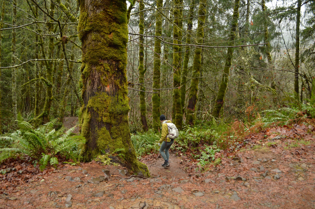
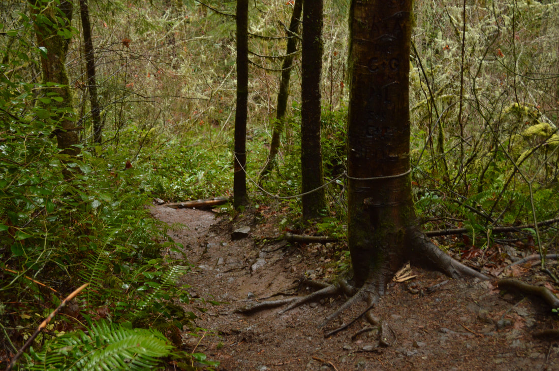
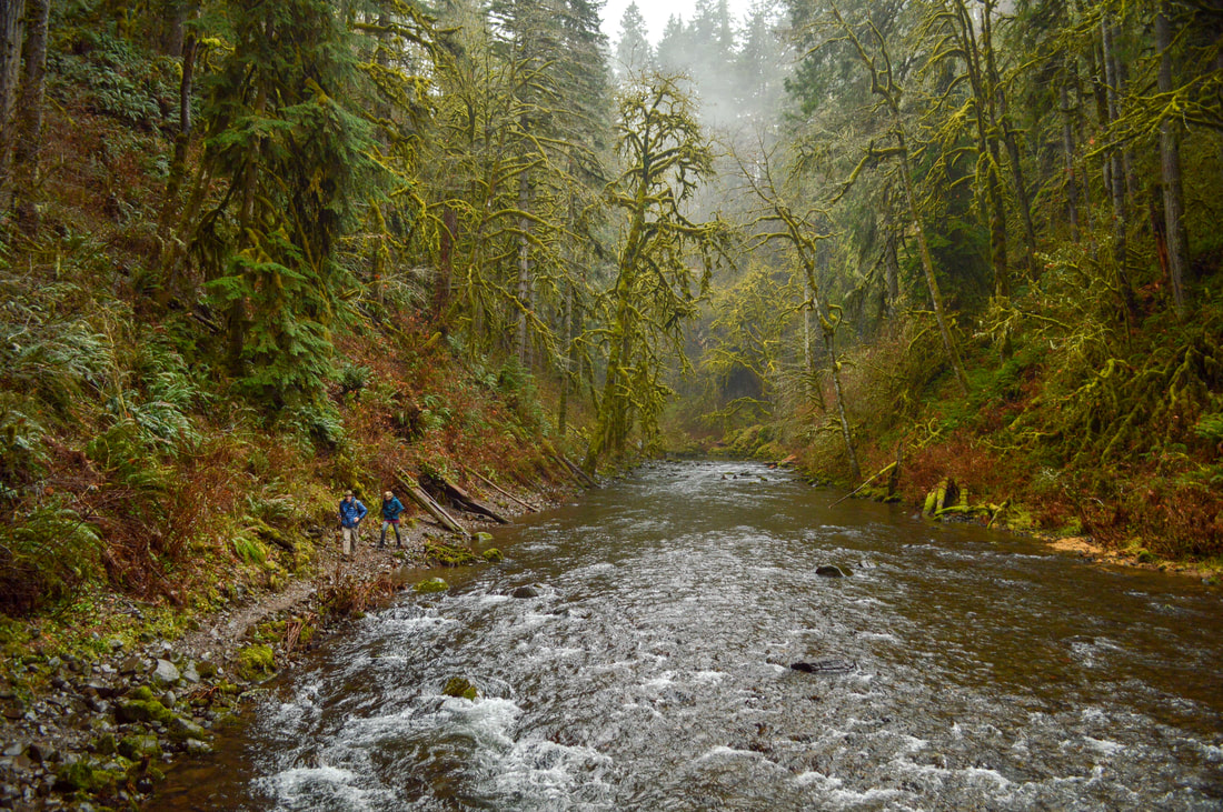
The trailhead is not marked, but you will see cars parked along the road and at the small parking area at the end of the road where a gate is. There are a few obvious trails, take the one to the left so that you don't end up going over a cliff. Once you hit the right trail it is very obvious as the dirt path meanders downhill. If it has rained recently the trail will be muddy and quite slippery. It is also very steep, so there have been ropes set up for assistance. Trekking poles help for going down quite a bit. From high up on the trail you will see Abiqua Creek a few hundred feet below. 
Abiqua Creek
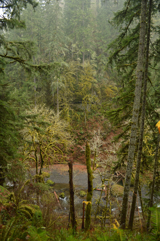
(Abiqua Creek below the trail)
Steep trail to Abiqua Falls
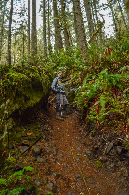
(using a rope on a 70% grade)
Trail along Abiqua Creek
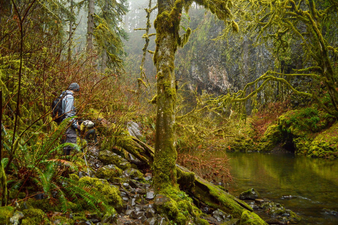
(the trail is right at the edge of Abiqua Creek)
After climbing down to the creek's edge, the trail continues right along the shore line. You will have to climb over some down logs and debris that gets washed up onto the shore during high waters early in the season. Once you round the corner you will be standing in the Abiqua Falls amphitheater. 
Abiqua Falls Trail
First glimpse of Abiqua Falls
Abiqua Creek originates near Lookout Mountain and flows 29 miles northwest to its confluence with Pudding Creek about 2 miles west of Silverton. Abiqua Creek is Silverton's main source of drinking water. It was along Abiqua Creek that a skirmish/battle was fought in March of 1848 where several native Americans were killed. The meaning of the word Abiqua is unknown, but thoughts are that it referred to a small tribe or a camping place along the creek.
Abiqua Falls amphitheater
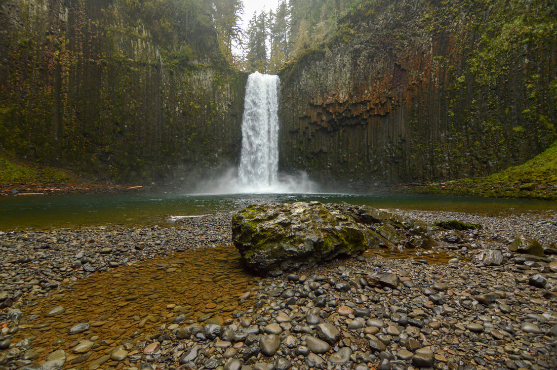
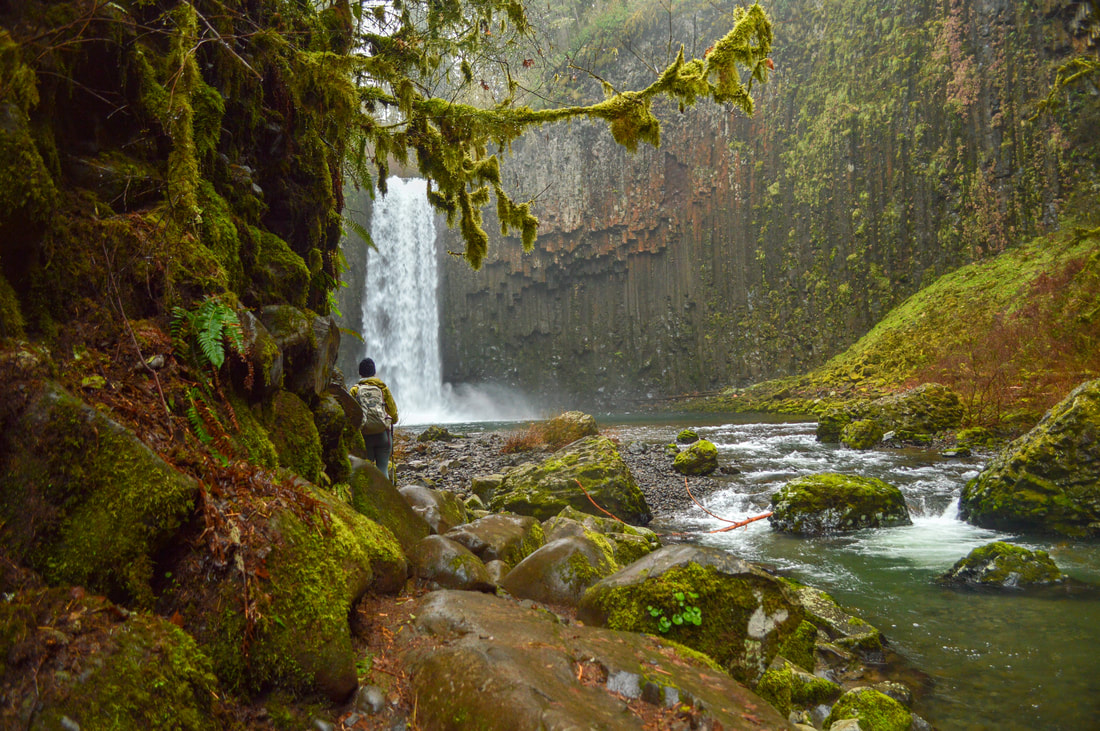
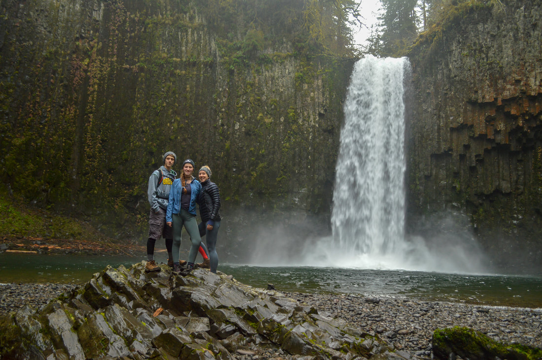
(Abiqua Falls 92 ft.)
It is really quite an amazing sight and the basalt columns have broken off in different lengths which creates texture on the amphitheater walls. Orange and green lichen grow on the rocks here, making the cliff walls look like a painting. Abiqua Falls is 92 feet tall and it plunges down with quite a force, especially in the springtime, into a emerald green pool or round river rocks. 
This hike is quite popular, so usually there are many people enjoying the falls with you. However, if you come early enough in the day, you might get lucky and get it all to yourself for a bit like we did one day in late December. 
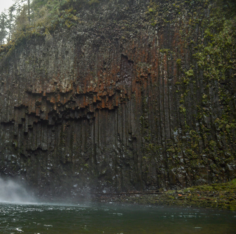
Basalt columns at Abiqua Falls
(basalt columns)
Abiqua Falls
Abiqua is one of Oregon's most popular waterfalls and for good reason. It is a bit difficult to get to both by car and on foot, and if you have knee problems, it is not recommended that you go down the incredibly steep path. This trail is also not recommended for very small children unless you are carrying them in a pack. Please be careful in this area and make sure to stay on the trail. Do not go near any of the cliffs, and if the river is too high to be able to see the trail below, please do not side-hill and bushwhack to the falls. Always remember to Leave No Trace! People have fallen here and had to get life flighted out (see article). 
Abiqua Creek valley forest

Directions:

From Salem
  • Drive on Silverton Rd. NE for 11.3 miles to the town of Silverton. Continue through town following signs for OR-213 N and then stay on this road for 4.8 miles then turn right onto Mount Angel Scotts Mills Rd. NE for 2.3 miles through the tiny town of Scotts Mills. Right before a bridge, turn right onto Crooked Finger Rd. NE for 10.8 miles, then turn right onto CF-300. Continue down this rough road slowly for 2.5 miles to a locked gate and a wide turnout on the left. You can park here but there is only enough room for about 5-7 cars so if there is no parking you can park at one of the many turnouts along the road. This road is rough and it has some large rough rocks sticking up from the ground. If you have a high clearance vehicle, it is preferred. Many people feel uncomfortable driving down this road in their passenger cars, although it can be done at very slow speeds.  (Total of  31.7 miles)
From Portland
  • Drive I-5 south for 16.9 miles then take exit 282A toward Canby/Hubbard and take the Portland-Hubbard Hwy. 1.1 miles and then turn left onto Arndt Rd. for 1.8 miles then stay right onto S Arndt Rd. for another half mile until you T into S Barlow Rd. Turn right and say on this road for 7 miles before turning left onto S Sconce Rd. for 2 miles. Turn right onto Canby-Marquam Hwy for 1.9 miles which then turns into S Kropf Rd. Stay on this road for 4.2 miles and then turn right onto OR-213 south and immediately turn left onto S Nowlens Bridge Rd. Turn left onto Cooked Finger Rd. NE for 10.8 miles and then turn right onto CF-300. Continue down this rough road slowly for 2.5 miles to a locked gate and a wide turnout on the left. You can park here but there is only enough room for about 5-7 cars so if there is no parking you can park at one of the many turnouts along the road. This road is rough and it has some large rough rocks sticking up from the ground. If you have a high clearance vehicle, it is preferred. Many people feel uncomfortable driving down this road in their passenger cars, although it can be done at very slow speeds.  (Total of 51 miles)
From Eugene
  • Drive I-5 north to Salem for 62.1 miles, then take exit 256 to merge onto OR-213 N/Market St. NE toward Silverton. After about 10 miles you will drive through the town of Silverton. Continue through town following signs for OR-213 N and then stay on this road for 4.8 miles then turn right onto Mount Angel Scotts Mills Rd. NE for 2.3 miles through the tiny town of Scotts Mills. Right before a bridge, turn right onto Crooked Finger Rd. NE for 10.8 miles, then turn right onto CF-300. Continue down this rough road slowly for 2.5 miles to a locked gate and a wide turnout on the left. You can park here but there is only enough room for about 5-7 cars so if there is no parking you can park at one of the many turnouts along the road. This road is rough and it has some large rough rocks sticking up from the ground. If you have a high clearance vehicle, it is preferred. Many people feel uncomfortable driving down this road in their passenger cars, although it can be done at very slow speeds.  (Total of 94.8 miles)
From Bend
  • Drive US-97 north and take exit 135A to merge onto US-120 west toward Sisters for 19.9 miles. At the roundabout in Sisters, take the 2nd exit and stay on US-20 west for another 25.1 miles. Then turn right onto OR-22 west/N Santiam Hwy E toward Salem for 68.1 miles. Take exit 13 toward Stayton/Sublimity. Turn right onto Cascade Hwy SE/S Center St. and stay on this road for 12.7 miles until you get to the town of Silverton. Continue through town following signs for OR-213 N and then stay on this road for 4.8 miles then turn right onto Mount Angel Scotts Mills Rd. NE for 2.3 miles through the tiny town of Scotts Mills. Right before a bridge, turn right onto Crooked Finger Rd. NE for 10.8 miles, then turn right onto CF-300. Continue down this rough road slowly for 2.5 miles to a locked gate and a wide turnout on the left. You can park here but there is only enough room for about 5-7 cars so if there is no parking you can park at one of the many turnouts along the road. This road is rough and it has some large rough rocks sticking up from the ground. If you have a high clearance vehicle, it is preferred. Many people feel uncomfortable driving down this road in their passenger cars, although it can be done at very slow speeds. (Total of 148 miles)
From Medford
  • Drive I-5 north  226 miles to Salem, then take exit 256 to merge onto OR-213 N/Market St. NE toward Silverton. After about 10 miles you will drive through the town of Silverton. Continue through town following signs for OR-213 N and then stay on this road for 4.8 miles then turn right onto Mount Angel Scotts Mills Rd. NE for 2.3 miles through the tiny town of Scotts Mills. Right before a bridge, turn right onto Crooked Finger Rd. NE for 10.8 miles, then turn right onto CF-300. Continue down this rough road slowly for 2.5 miles to a locked gate and a wide turnout on the left. You can park here but there is only enough room for about 5-7 cars so if there is no parking you can park at one of the many turnouts along the road. This road is rough and it has some large rough rocks sticking up from the ground. If you have a high clearance vehicle, it is preferred. Many people feel uncomfortable driving down this road in their passenger cars, although it can be done at very slow speeds. (Total of 258 miles)
To get a more in-depth and personal view of this hike, watch the YouTube video.
-This trail write-up was last updated January 2018-
*All pictures are taken by Franziska Weinheimer
*Disclaimer: The trail descriptions, mileage, GPS tracks and difficulty ratings depicted on this website are never 100% accurate. Always hike at your own risk, using your own knowledge, equipment and common sense. Franziska Weinheimer/Hike Oregon are not responsible if you or anyone in your party gets injured or lost while attempting one of these or any other hikes. ​

​HIKED HERE RECENTLY? PLEASE LEAVE A TRIP REPORT BELOW:

© Hike Oregon 2025
P.O. Box 41911
​Eugene, OR 97404
Proudly powered by Weebly
  • Home
  • *Store*
  • About the author
  • How to use this site
  • Resources
    • Wildflowers
    • Videos
  • Best Oregon Hikes
    • 20 Epic Oregon Wildflower Hikes
    • 5 Weekend Backpacking Trips in Oregon
    • Top 10 Swimming Spots In Oregon
    • 9 Amazing Oregon Summit Hikes
    • Top 10 Oregon Summer Hikes
    • 20 Central Oregon Day Hikes
    • Top One Night Backpacking Trips in Central Oregon
    • Top 10 Oregon Hikes for Kids
    • 20 Best Oregon Waterfall Hikes
    • Underrated Fall Foliage Hikes In Oregon
    • Top 10 Oregon Fall Hikes
    • Best Rainy Day Hikes In Oregon
    • Sno-Parks In Central Oregon
    • Top 10 Oregon Winter Hikes
    • Top Low Elevation Winter Hikes
    • Easy Hikes in Oregon
    • Top 10 Oregon Spring Hikes
  • Oregon Sno-Parks
    • Maxwell Sno-Park
    • Potato Hill Sno-Park
    • Ray Benson Sno-Park
      • Brandenburg Shelter
    • Santiam Sno-Park
    • Three Creek Sno-Park
    • Virginia Meissner Sno-Park
      • Meissner Shelter Loop
      • Nordeen Shelter
    • Gold Lake Sno-Park
      • Westview Shelter to Eagle Rock Overlook
      • Marilyn Lakes Loop
    • Ikenick Sno-Park (members only)
  • Southern Washington
    • Hamilton Mountain
    • Dog Mountain
    • Coyote Wall
    • Mount St. Helens
  • Portland
    • Powell Butte
    • Forest Park
    • Latourell Falls
    • Multnomah/Wahkeena Falls
    • Eagle Creek
    • Mitchell Point
    • Table Rock
    • Tamanawas Falls
    • Trillium Lake
    • East Zigzag Mountain (members only)
  • Salem
    • Abiqua Falls
    • Silver Falls State Park
    • Dome Rock
    • Marion Lake to Marion Mountain
    • Jefferson Park via Whitewater Trail
  • Corvallis
    • William Finley Wildlife Refuge
      • Campbell Boardwalk
      • Woodpecker Loop
      • Mill Hill Loop
      • Beaver Pond Loop
    • Marys Peak East Ridge
    • Marys Peak North Ridge
    • Alsea Falls and Green Peak Falls
    • Corvallis to Sea Trail - Sugarbowl Creek segment (members only)
  • Sweet Home
    • Crescent Mountain
    • Iron Mountain
    • McDowell Creek Falls
    • Middle Santiam River (members only)
    • Lower Soda Creek Falls (members only)
    • Rooster Rock (members only)
  • McKenzie Bridge/Blue River
    • Macduff Mountain
    • Proxy Falls
    • Clear Lake
    • Sahalie/Koosah Falls
    • Blue Pool
    • Erma Bell Lakes
    • Olallie Mountain
    • Horsepasture Mountain
    • Tidbits Mountain
    • Castle Rock
    • Separation Lake (members only)
    • Lowder Mountain (members only)
    • East Fork Trail (members only)
    • Rainbow Falls Overlook (members only)
    • Frissell Point (members only)
    • Substitute Point (members only)
  • Sisters/Santiam Pass
    • Coffin Mountain
    • Trappers Butte and Scar Mountain
    • Maxwell Butte
    • Black Butte
    • Whychus Creek Trail
    • Tam McArthur Rim
    • Black Crater
    • Scott Mountain
    • Obsidian Trail
    • Metolius Preserve
    • Three Fingered Jack Loop
    • Square Lake
    • Canyon Creek Meadows
    • Patjens Lakes
    • Craig Lake (members only)
    • Chush Falls (members only)
    • Rockpile Lake (members only)
    • Santiam Lake (members only)
    • Camp Lake (members only)
    • Park Meadow to Golden Lake (members only)
  • Bend/Redmond/LaPine
    • Steins Pillar
    • Chimney Rock
    • Steelhead Falls
    • Tumalo State Park
    • Shevlin Park Loop
    • Tumalo Falls
    • Tumalo Mountain
    • No Name Lake
    • Green Lakes
    • Moraine Lake
    • South Sister Summit
    • Horse Lake
    • Muskrat Lake
    • Paulina Peak
    • The Badlands - Flatiron Rock Trail
    • Peter Skene Ogden Trail (members only)
  • Eugene
    • Ridgeline Trail
    • Mount Pisgah Summit
    • Mount Pisgah Arboretum
    • Shotgun Creek
    • Mount June
    • Lawler
    • Tire Mountain
    • Hardesty Mountain
    • Goodman Creek
    • Brice Creek
    • Trestle Creek Falls
    • Parker Falls
    • Moon Falls
    • Elijah Bristow State Park
    • South Willamette Trail (members only)
    • Eula Ridge (members only)
    • Eagle's Rest (members only)
  • Oakridge
    • Deception Butte
    • North Salmon Creek
    • Sourgrass Mountain
    • Grasshopper Ridge
    • Larison Creek
    • Bunchgrass Ridge
    • Salt Creek Falls
    • Waldo Lake Loop
    • South Waldo Loop
    • The Twins
    • Rosary Lakes
    • Yoran Lake
    • Fawn Lake
    • Windy Lakes
    • Divide Lake
    • Diamond Peak via Rockpile Lake Trailhead
    • Diamond Peak via Summit Lake
    • Cowhorn Mountain
    • Klovdahl Bay (members only)
    • Verdun Trail (members only)
    • Heckletooth Mountain (members only)
    • Wall Creek Warm Springs (members only)
    • Moon Point (members only)
    • Bobby Lake (members only)
    • Lillian Falls (members only)
    • Middle Fork Willamette Trail (members only)
    • Pool Creek Falls (members only)
    • Dead Mountain (members only)
    • Larison Rock (members only)
    • Quinn Lakes & Eddeeleo Lakes (members only)
    • Waldo Mountain Lookout (members only)
    • Blair Lake to Spring Prairie (members only)
    • Rigdon Lakes loop (members only)
  • Oregon Coast
    • Cascade Head
    • Drift Creek Falls
    • Sweet Creek Falls
    • Beaver Creek Falls
    • Kentucky Falls
    • Hobbit Trail to Heceta Head
    • Valley Trail to China Creek
    • Sutton Creek Trail (members only)
    • North Fork Smith River (members only)
    • Cummins Ridge (member's only)
    • Horse Creek (members only)
    • Siltcoos Lake (members only)
  • Southern Oregon
    • Fall Creek Falls
    • Watson Falls
    • Wild Rogue Loop
    • Mt. Thielsen
    • Crater Lake National Park
      • The Watchman
      • Mount Scott
      • The Pinnacles
    • Lower Table Rock
    • Pilot Rock
    • Wagner Butte
    • Mt. McLoughlin
    • Lemolo Falls (members only)
    • Fern Falls (members only)
  • Eastern Oregon
    • Painted Cove
    • Anthony Lake Loop
    • Mount Howard
    • Eagle Cap summit
    • Schneider Cabin (members only)
    • Strawberry Lake & Strawberry Falls (members only)
  • Northern California
    • Taylor & Hogan Lake (members only)
  • Oregon PCT sections
    • PCT: CA border to Callahan's
  • Tips & Tricks
    • Leave No Trace
    • Safety Tips for Solo Hiking & Backpacking
    • Nutrition On The Trail
    • How Much Water To Carry When Backpacking
    • Storing Your Bear Canister When Backpacking
    • How To Pick The Right Backpacking Tent
    • Top Tips For Hiking With Infants And Toddlers
    • Poison Oak, Ivy and Sumac
    • How to dress for cold weather hikes
  • Reviews and Gear
    • Choosing and Using Trekking Poles
    • A Guide to Choosing the Perfect Backpacking Pack
    • Hiking Pants and Leggings
    • Jackets for Hiking and Backpacking
    • Long Sleeved Shirts For Cold Weather Hiking
    • Stay Kühl This Summer
    • Outdoor Herbivore Backpacking Food Review
    • Osprey Aura AG 65 Backpack review
    • Big Agnes Fly Creek UL2 review
    • REI Quarter Dome 1 review
    • Hike Oregon's Gear Favorites
    • Outdoorsy Holiday Gift Guide 2022
    • Hiker Holiday Gift Guide 2019
    • Outdoor Holiday Gift Guide 2018
    • Hiking Holiday Gift Guide 2017
  • Adventure Stories
    • Hiking The Rae Lakes Loop
    • 110 Miles on the PCT
    • Three Fingered Jack Adventures
    • Jefferson Wilderness