Hike Oregon
  • Home
  • *Store*
  • About the author
  • How to use this site
  • Resources
    • Wildflowers
    • Videos
  • Best Oregon Hikes
    • Best Rainy Day Hikes In Oregon
    • Top 10 Oregon Fall Hikes
    • Underrated Fall Foliage Hikes In Oregon
    • 20 Best Oregon Waterfall Hikes
    • Sno-Parks In Central Oregon
    • Top 10 Oregon Winter Hikes
    • Top Low Elevation Winter Hikes
    • Easy Hikes in Oregon
    • Top 10 Oregon Hikes for Kids
    • Top 10 Oregon Spring Hikes
    • Top One Night Backpacking Trips in Oregon
    • 5 Weekend Backpacking Trips in Oregon
    • 20 Epic Oregon Wildflower Hikes
    • 9 Amazing Oregon Summit Hikes
    • Top 10 Oregon Summer Hikes
    • Top 10 Swimming Spots In Oregon
    • 20 Central Oregon Day Hikes
  • Oregon Sno-Parks
    • Maxwell Sno-Park
    • Potato Hill Sno-Park
    • Ray Benson Sno-Park
      • Brandenburg Shelter
    • Santiam Sno-Park
    • Three Creek Sno-Park
    • Virginia Meissner Sno-Park
      • Meissner Shelter Loop
      • Nordeen Shelter
    • Gold Lake Sno-Park
      • Westview Shelter to Eagle Rock Overlook
      • Marilyn Lakes Loop
    • Ikenick Sno-Park (members only)
  • Southern Washington
    • Hamilton Mountain
    • Dog Mountain
    • Coyote Wall
    • Mount St. Helens
  • Portland
    • Powell Butte
    • Forest Park
    • Latourell Falls
    • Multnomah/Wahkeena Falls
    • Eagle Creek
    • Mitchell Point
    • Table Rock
    • Tamanawas Falls
    • Trillium Lake
    • East Zigzag Mountain (members only)
  • Salem
    • Abiqua Falls
    • Silver Falls State Park
    • Dome Rock
    • Marion Lake to Marion Mountain
    • Jefferson Park via Whitewater Trail
  • Corvallis
    • William Finley Wildlife Refuge
      • Campbell Boardwalk
      • Woodpecker Loop
      • Mill Hill Loop
      • Beaver Pond Loop
    • Marys Peak East Ridge
    • Marys Peak North Ridge
    • Alsea Falls and Green Peak Falls
    • Corvallis to Sea Trail - Sugarbowl Creek segment (members only)
  • Sweet Home
    • Crescent Mountain
    • Iron Mountain
    • McDowell Creek Falls
    • Middle Santiam River (members only)
    • Lower Soda Creek Falls (members only)
    • Rooster Rock (members only)
  • McKenzie Bridge/Blue River
    • Macduff Mountain
    • Proxy Falls
    • Clear Lake
    • Sahalie/Koosah Falls
    • Blue Pool
    • Erma Bell Lakes
    • Olallie Mountain
    • Horsepasture Mountain
    • Tidbits Mountain
    • Castle Rock
    • Separation Lake (members only)
    • Lowder Mountain (members only)
    • East Fork Trail (members only)
    • Rainbow Falls Overlook (members only)
    • Frissell Point (members only)
    • Substitute Point (members only)
  • Sisters/Santiam Pass
    • Coffin Mountain
    • Trappers Butte and Scar Mountain
    • Maxwell Butte
    • Black Butte
    • Whychus Creek Trail
    • Tam McArthur Rim
    • Black Crater
    • Scott Mountain
    • Obsidian Trail
    • Metolius Preserve
    • Three Fingered Jack Loop
    • Square Lake
    • Canyon Creek Meadows
    • Patjens Lakes
    • Craig Lake (members only)
    • Chush Falls (members only)
    • Rockpile Lake (members only)
    • Santiam Lake (members only)
    • Camp Lake (members only)
    • Park Meadow to Golden Lake (members only)
  • Bend/Redmond/LaPine
    • Steins Pillar
    • Chimney Rock
    • Steelhead Falls
    • Tumalo State Park
    • Shevlin Park Loop
    • Tumalo Falls
    • Tumalo Mountain
    • No Name Lake
    • Green Lakes
    • Moraine Lake
    • South Sister Summit
    • Horse Lake
    • Muskrat Lake
    • Paulina Peak
    • The Badlands - Flatiron Rock Trail
    • Peter Skene Ogden Trail (members only)
  • Eugene
    • Ridgeline Trail
    • Mount Pisgah Summit
    • Mount Pisgah Arboretum
    • Shotgun Creek
    • Mount June
    • Lawler
    • Tire Mountain
    • Hardesty Mountain
    • Goodman Creek
    • Brice Creek
    • Trestle Creek Falls
    • Parker Falls
    • Moon Falls
    • Elijah Bristow State Park
    • South Willamette Trail (members only)
    • Eula Ridge (members only)
    • Eagle's Rest (members only)
  • Oakridge
    • Deception Butte
    • North Salmon Creek
    • Sourgrass Mountain
    • Grasshopper Ridge
    • Larison Creek
    • Bunchgrass Ridge
    • Salt Creek Falls
    • Waldo Lake Loop
    • South Waldo Loop
    • The Twins
    • Rosary Lakes
    • Yoran Lake
    • Fawn Lake
    • Windy Lakes
    • Divide Lake
    • Diamond Peak via Rockpile Lake Trailhead
    • Diamond Peak via Summit Lake
    • Cowhorn Mountain
    • Klovdahl Bay (members only)
    • Verdun Trail (members only)
    • Heckletooth Mountain (members only)
    • Wall Creek Warm Springs (members only)
    • Moon Point (members only)
    • Bobby Lake (members only)
    • Lillian Falls (members only)
    • Middle Fork Willamette Trail (members only)
    • Pool Creek Falls (members only)
    • Dead Mountain (members only)
    • Larison Rock (members only)
    • Quinn Lakes & Eddeeleo Lakes (members only)
    • Waldo Mountain Lookout (members only)
    • Blair Lake to Spring Prairie (members only)
    • Rigdon Lakes loop (members only)
  • Oregon Coast
    • Cascade Head
    • Drift Creek Falls
    • Sweet Creek Falls
    • Beaver Creek Falls
    • Kentucky Falls
    • Hobbit Trail to Heceta Head
    • Valley Trail to China Creek
    • Sutton Creek Trail (members only)
    • North Fork Smith River (members only)
    • Cummins Ridge (member's only)
    • Horse Creek (members only)
    • Siltcoos Lake (members only)
  • Southern Oregon
    • Fall Creek Falls
    • Watson Falls
    • Wild Rogue Loop
    • Mt. Thielsen
    • Crater Lake National Park
      • The Watchman
      • Mount Scott
      • The Pinnacles
    • Lower Table Rock
    • Pilot Rock
    • Wagner Butte
    • Mt. McLoughlin
    • Lemolo Falls (members only)
    • Fern Falls (members only)
  • Eastern Oregon
    • Painted Cove
    • Anthony Lake Loop
    • Mount Howard
    • Eagle Cap summit
    • Schneider Cabin (members only)
    • Strawberry Lake & Strawberry Falls (members only)
  • Northern California
    • Taylor & Hogan Lake (members only)
  • Oregon PCT sections
    • PCT: CA border to Callahan's
  • Tips & Tricks
    • Leave No Trace
    • Safety Tips for Solo Hiking & Backpacking
    • Nutrition On The Trail
    • How Much Water To Carry When Backpacking
    • Storing Your Bear Canister When Backpacking
    • How To Pick The Right Backpacking Tent
    • Top Tips For Hiking With Infants And Toddlers
    • Poison Oak, Ivy and Sumac
    • How to dress for cold weather hikes
  • Reviews and Gear
    • Choosing and Using Trekking Poles
    • A Guide to Choosing the Perfect Backpacking Pack
    • Hiking Pants and Leggings
    • Jackets for Hiking and Backpacking
    • Long Sleeved Shirts For Cold Weather Hiking
    • Stay Kühl This Summer
    • Outdoor Herbivore Backpacking Food Review
    • Osprey Aura AG 65 Backpack review
    • Big Agnes Fly Creek UL2 review
    • REI Quarter Dome 1 review
    • Hike Oregon's Gear Favorites
    • Outdoorsy Holiday Gift Guide 2022
    • Hiker Holiday Gift Guide 2019
    • Outdoor Holiday Gift Guide 2018
    • Hiking Holiday Gift Guide 2017
  • Adventure Stories
    • Hiking The Rae Lakes Loop
    • 110 Miles on the PCT
    • Three Fingered Jack Adventures
    • Jefferson Wilderness

Square Lake, Round Lake & Booth Lake

​
Get the printable version of this hike

Hike details:

​Mileage: 4.8 miles round trip w/ 550 ft. elevation gain (to Square Lake and back)
9.4 miles round trip w/ 860 ft. elevation gain (to Square Lake & Round Lake and back)
8.3 miles round trip w/ 1,100 ft. elevation gain (to Square Lake & Booth Lake and back)
Approximate hike time: 2 hours 5 minutes w/ an average pace of 2.3 mph (to Square Lake and back)
4 hours 5 minutes w/ an average pace of 2.3 mph (to Square Lake & Round Lake and back)
3 hours 36 minutes w/ an average pace of 2.3 mph (to Square Lake & Booth Lake and back)
Difficulty: Easy to moderate
Trail usage: Medium on summer weekends, low on weekdays
Highest elevation: 5,269 ft. Lowest elevation: 4,330 ft.
General location: 20 miles west of Sisters - Willamette National Forest - Mount Jefferson Wilderness
Accessible: June through November
(Best time to go is June and then again towards the end of September through November when the weather is cooler).
Permits required: Day trips - Free self issue wilderness permit June 15 - October 15 and Northwest Forest Pass for parking. 
Overnight trips - Central Cascades Wilderness Permit June 15 - October 15 via recreation.gov and Northwest Forest Pass for parking. 
Pit toilet at trailhead: Yes
Trail allows: Dogs, horses, camping
Possible dangers: ​This trail is very exposed to the sun so it gets extremely hot in the summer.
Old Summit Trail
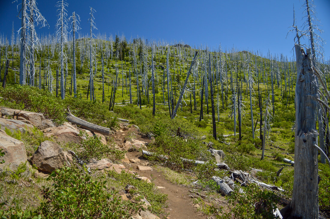
(an example of what the Old Summit Trail looks like)

Description:

Square Lake can be accessed via the Old Summit Trail #4014 and is a short and easy family friendly hike, perfect for early summer. From Square Lake you can choose to continue on to Booth Lake, a wonderful place to camp, or Round Lake, perfect for an afternoon swim. 
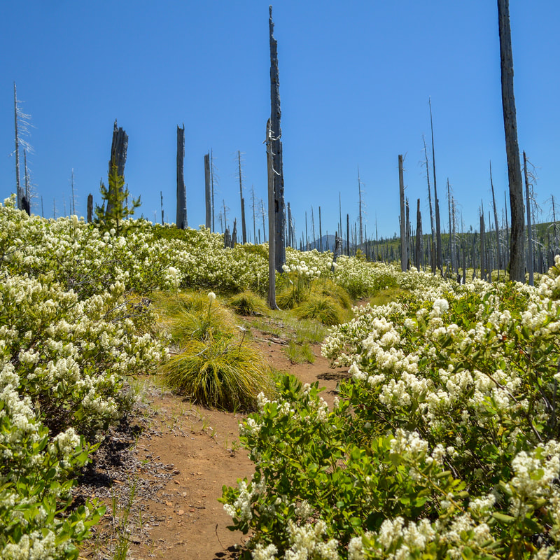
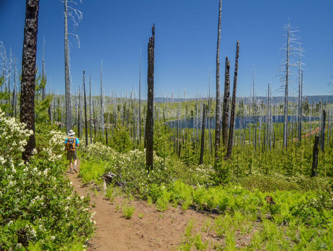
The hike starts out on the Pacific Crest Trail, heading northbound through bushels of bear grass and silvery tree snags that remain from the very large B&B Complex fire in 2003. After 0.2 miles you will come to a trail junction and you will take the Old Summit Trail #4014 to the right. 
view of Mount Washington from Old Summit Trail
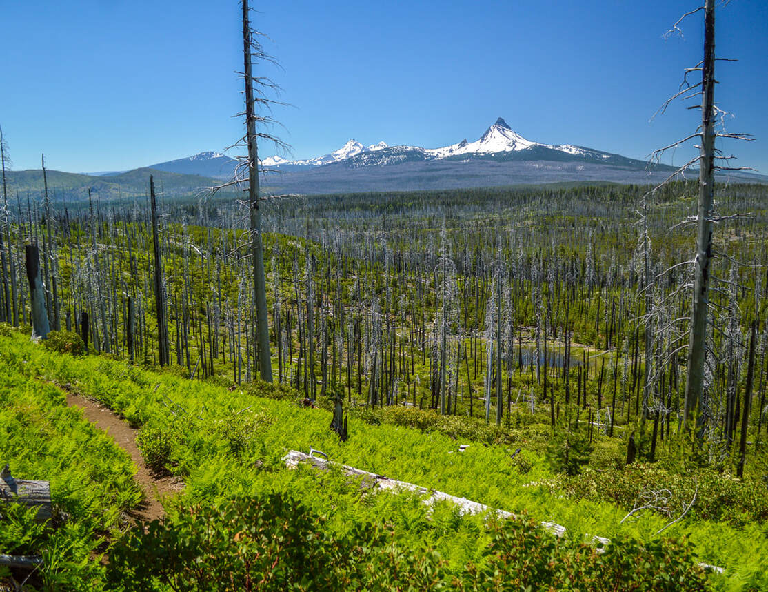
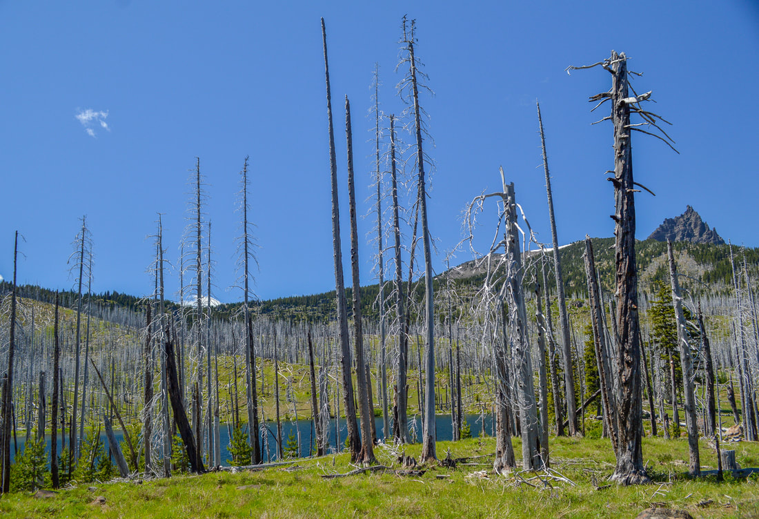
(view of Mount Washington and the Three Sisters from Old Summit Trail)
view of Three Fingered Jack from Old Summit Trail
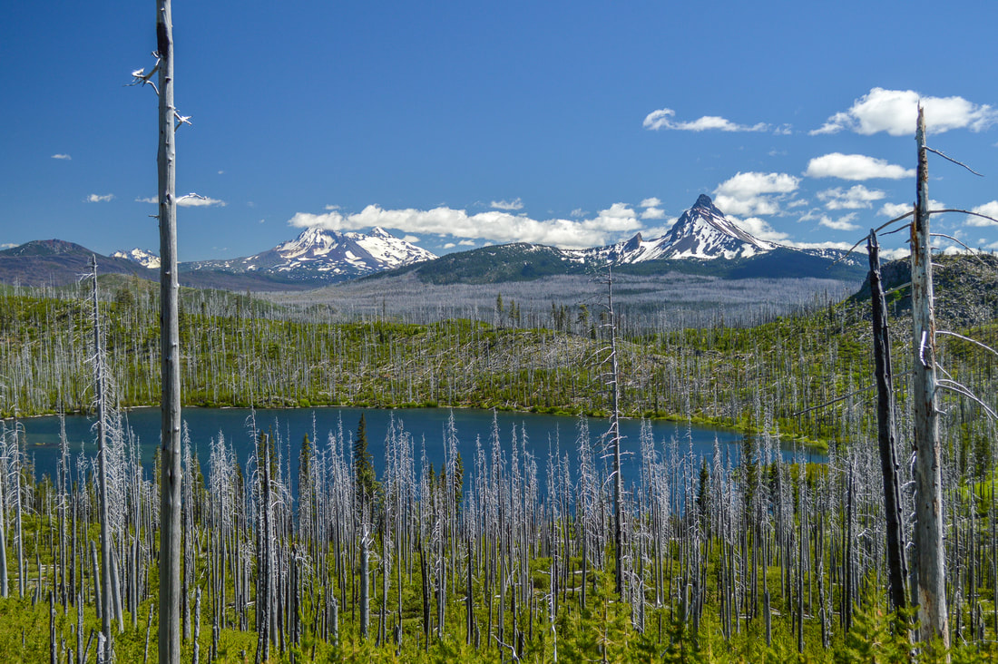
The Old Summit Trail takes you around a small hill, and the old burn exposes epic views to the north of Mount Washington and the Three Sisters. After 1.5 miles you will come to small saddle and from here you can see Square Lake below with Three Fingered Jack in the distance. From the saddle, the trail takes you downhill for 0.65 miles to the banks of Square Lake. You will see a few decent backcountry camp spots on the north and south shores and the deep blue color of the lake is very inviting, especially on a hot summer day. Square Lake also has trout, so bring the fishing pole, a hammock and a book and enjoy a relaxing afternoon.  
view of Square Lake and Three Fingered Jack
(view of Square Lake and Three Fingered Jack)
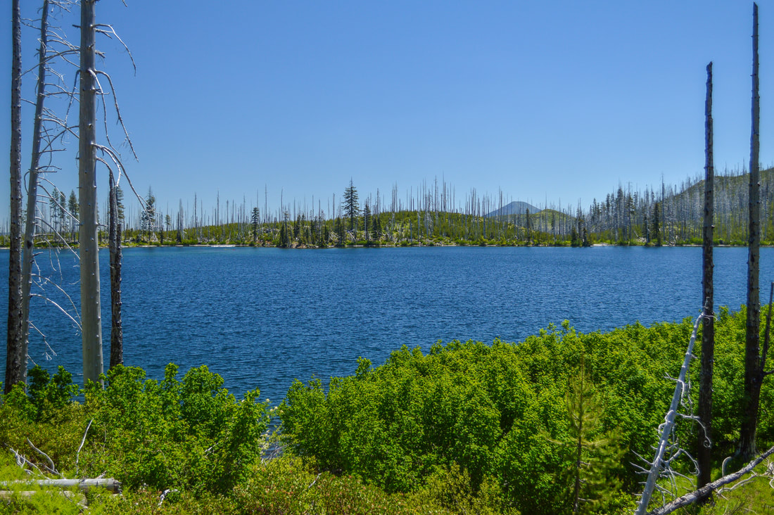
the edge of Square Lake
(Square Lake)
Snow bush blooming along the Round Lake Trail
If you want to continue your hike, at the north end of Square Lake you will find a trail junction. If you want to go to Round Lake, you will take the Round Lake Trail #4012 to the right. This dusty trail takes you through lots of snowbush, which blooms in June. These flowers have an incredibly potent smell! After 2 miles you will arrive at a gravel road that skirts around the edge of Round Lake. At the west side of the lake you will see Round Lake Christian Camp and at the east side of the lake there is primitive Round Lake Campground. This lake is smaller than Square Lake and you have to share it with the church camp and folks camping at the campground, so unless you are here in the early season or in the fall, this lake will not be secluded. 
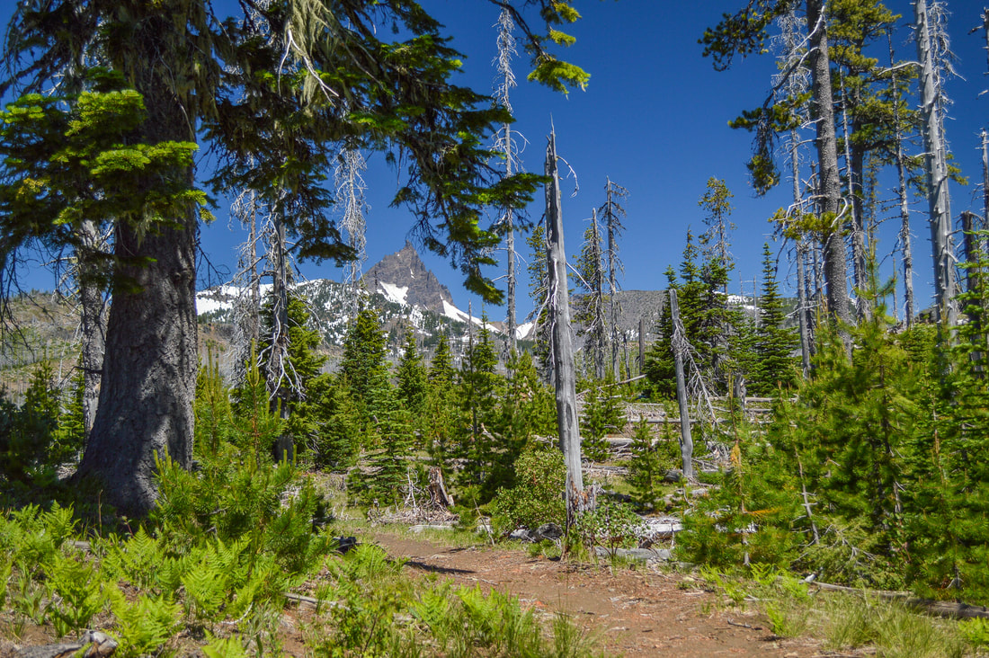
For a more private lake experience, head over to Booth Lake instead. From the Square Lake trail junction you will continue north on the Old Summit Trail for 1.75 uphill miles. Booth Lake is stunning and sits at the base of a ridge. You can see Three Fingered Jack looming above, and it is generally pretty quiet here. Keep in mind that there are no big trees here so you will be in the sun the entire day. Make sure to bring a sun hat when hiking in this area and apply that sunscreen! If you have an overnight permit and have backpacked in, there are places to set up camp at Booth Lake as well. 
Round Lake Trail
(approaching Round Lake)
Booth Lake and Three Fingered Jack
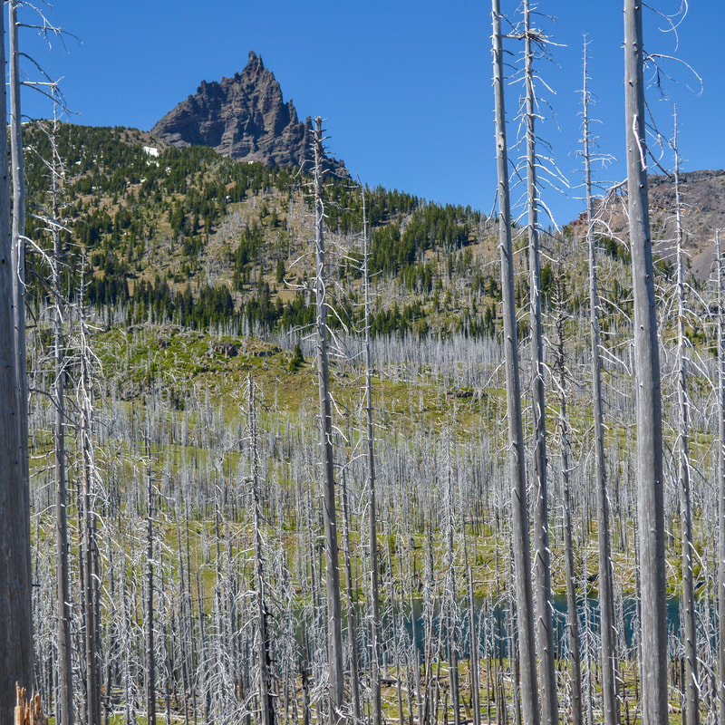
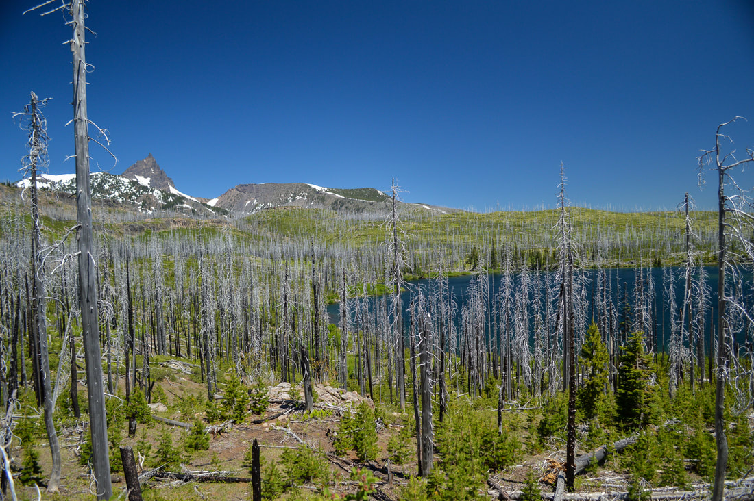
(Booth Lake and Three Fingered Jack)
Booth Lake
(Booth Lake)
Whether you are simply going to Square Lake, or also going to Round Lake or Booth Lake, you will head back the way you came on the Old Summit Trail. This southeast side of Three Fingered Jack is underrated and doesn't get visited as much as Minto Lake, Jack Lake, Canyon Creek Meadows or Santiam Lake. This is an easy hike and it is truly the perfect place to bring the whole family in the early summer season.
view of Square Lake and Mount Washington
(view of Square Lake, Mount Washington and the Three Sisters on your way back from Booth Lake)

Directions:

From Sisters
  • Drive on US-20 W for a total of  20.2 miles, then turn right at a sign for Pacific Crest Trail. Drive 0.5 miles up to the circular parking area. (Total of 20.7 miles)
From Salem
  • ​Drive on OR-22 E for a total of 80.2 miles, then make a slight left onto US-20 E for 5.4 miles. Turn left at a sign for Pacific Crest Trail. Drive 0.5 miles up to the circular parking area. (Total of 89.6 miles)
From Eugene
  • Drive on OR-126 E for a total of 68.2 miles, then merge right onto US-20 E for 8.8 miles. Turn left at a sign for Pacific Crest Trail. Drive 0.5 miles up to the circular parking area. (Total of 86.2 miles)
From Bend
  • Total of 43.2 miles via Sisters.
From Medford
  • ​Total of 215 miles via Bend and Sisters.
-This trail write-up was last updated in 2022-
​*All pictures are taken by Franziska Weinheimer
*Disclaimer: The trail descriptions, mileage, GPS tracks and difficulty ratings depicted on this website are never 100% accurate. Always hike at your own risk, using your own knowledge, equipment and common sense. Franziska Weinheimer/Hike Oregon are not responsible if you or anyone in your party gets injured or lost while attempting one of these or any other hikes. ​

HIKED HERE RECENTLY? PLEASE LEAVE A TRIP REPORT BELOW:

© Hike Oregon 2025
P.O. Box 41911
​Eugene, OR 97404
Proudly powered by Weebly
  • Home
  • *Store*
  • About the author
  • How to use this site
  • Resources
    • Wildflowers
    • Videos
  • Best Oregon Hikes
    • Best Rainy Day Hikes In Oregon
    • Top 10 Oregon Fall Hikes
    • Underrated Fall Foliage Hikes In Oregon
    • 20 Best Oregon Waterfall Hikes
    • Sno-Parks In Central Oregon
    • Top 10 Oregon Winter Hikes
    • Top Low Elevation Winter Hikes
    • Easy Hikes in Oregon
    • Top 10 Oregon Hikes for Kids
    • Top 10 Oregon Spring Hikes
    • Top One Night Backpacking Trips in Oregon
    • 5 Weekend Backpacking Trips in Oregon
    • 20 Epic Oregon Wildflower Hikes
    • 9 Amazing Oregon Summit Hikes
    • Top 10 Oregon Summer Hikes
    • Top 10 Swimming Spots In Oregon
    • 20 Central Oregon Day Hikes
  • Oregon Sno-Parks
    • Maxwell Sno-Park
    • Potato Hill Sno-Park
    • Ray Benson Sno-Park
      • Brandenburg Shelter
    • Santiam Sno-Park
    • Three Creek Sno-Park
    • Virginia Meissner Sno-Park
      • Meissner Shelter Loop
      • Nordeen Shelter
    • Gold Lake Sno-Park
      • Westview Shelter to Eagle Rock Overlook
      • Marilyn Lakes Loop
    • Ikenick Sno-Park (members only)
  • Southern Washington
    • Hamilton Mountain
    • Dog Mountain
    • Coyote Wall
    • Mount St. Helens
  • Portland
    • Powell Butte
    • Forest Park
    • Latourell Falls
    • Multnomah/Wahkeena Falls
    • Eagle Creek
    • Mitchell Point
    • Table Rock
    • Tamanawas Falls
    • Trillium Lake
    • East Zigzag Mountain (members only)
  • Salem
    • Abiqua Falls
    • Silver Falls State Park
    • Dome Rock
    • Marion Lake to Marion Mountain
    • Jefferson Park via Whitewater Trail
  • Corvallis
    • William Finley Wildlife Refuge
      • Campbell Boardwalk
      • Woodpecker Loop
      • Mill Hill Loop
      • Beaver Pond Loop
    • Marys Peak East Ridge
    • Marys Peak North Ridge
    • Alsea Falls and Green Peak Falls
    • Corvallis to Sea Trail - Sugarbowl Creek segment (members only)
  • Sweet Home
    • Crescent Mountain
    • Iron Mountain
    • McDowell Creek Falls
    • Middle Santiam River (members only)
    • Lower Soda Creek Falls (members only)
    • Rooster Rock (members only)
  • McKenzie Bridge/Blue River
    • Macduff Mountain
    • Proxy Falls
    • Clear Lake
    • Sahalie/Koosah Falls
    • Blue Pool
    • Erma Bell Lakes
    • Olallie Mountain
    • Horsepasture Mountain
    • Tidbits Mountain
    • Castle Rock
    • Separation Lake (members only)
    • Lowder Mountain (members only)
    • East Fork Trail (members only)
    • Rainbow Falls Overlook (members only)
    • Frissell Point (members only)
    • Substitute Point (members only)
  • Sisters/Santiam Pass
    • Coffin Mountain
    • Trappers Butte and Scar Mountain
    • Maxwell Butte
    • Black Butte
    • Whychus Creek Trail
    • Tam McArthur Rim
    • Black Crater
    • Scott Mountain
    • Obsidian Trail
    • Metolius Preserve
    • Three Fingered Jack Loop
    • Square Lake
    • Canyon Creek Meadows
    • Patjens Lakes
    • Craig Lake (members only)
    • Chush Falls (members only)
    • Rockpile Lake (members only)
    • Santiam Lake (members only)
    • Camp Lake (members only)
    • Park Meadow to Golden Lake (members only)
  • Bend/Redmond/LaPine
    • Steins Pillar
    • Chimney Rock
    • Steelhead Falls
    • Tumalo State Park
    • Shevlin Park Loop
    • Tumalo Falls
    • Tumalo Mountain
    • No Name Lake
    • Green Lakes
    • Moraine Lake
    • South Sister Summit
    • Horse Lake
    • Muskrat Lake
    • Paulina Peak
    • The Badlands - Flatiron Rock Trail
    • Peter Skene Ogden Trail (members only)
  • Eugene
    • Ridgeline Trail
    • Mount Pisgah Summit
    • Mount Pisgah Arboretum
    • Shotgun Creek
    • Mount June
    • Lawler
    • Tire Mountain
    • Hardesty Mountain
    • Goodman Creek
    • Brice Creek
    • Trestle Creek Falls
    • Parker Falls
    • Moon Falls
    • Elijah Bristow State Park
    • South Willamette Trail (members only)
    • Eula Ridge (members only)
    • Eagle's Rest (members only)
  • Oakridge
    • Deception Butte
    • North Salmon Creek
    • Sourgrass Mountain
    • Grasshopper Ridge
    • Larison Creek
    • Bunchgrass Ridge
    • Salt Creek Falls
    • Waldo Lake Loop
    • South Waldo Loop
    • The Twins
    • Rosary Lakes
    • Yoran Lake
    • Fawn Lake
    • Windy Lakes
    • Divide Lake
    • Diamond Peak via Rockpile Lake Trailhead
    • Diamond Peak via Summit Lake
    • Cowhorn Mountain
    • Klovdahl Bay (members only)
    • Verdun Trail (members only)
    • Heckletooth Mountain (members only)
    • Wall Creek Warm Springs (members only)
    • Moon Point (members only)
    • Bobby Lake (members only)
    • Lillian Falls (members only)
    • Middle Fork Willamette Trail (members only)
    • Pool Creek Falls (members only)
    • Dead Mountain (members only)
    • Larison Rock (members only)
    • Quinn Lakes & Eddeeleo Lakes (members only)
    • Waldo Mountain Lookout (members only)
    • Blair Lake to Spring Prairie (members only)
    • Rigdon Lakes loop (members only)
  • Oregon Coast
    • Cascade Head
    • Drift Creek Falls
    • Sweet Creek Falls
    • Beaver Creek Falls
    • Kentucky Falls
    • Hobbit Trail to Heceta Head
    • Valley Trail to China Creek
    • Sutton Creek Trail (members only)
    • North Fork Smith River (members only)
    • Cummins Ridge (member's only)
    • Horse Creek (members only)
    • Siltcoos Lake (members only)
  • Southern Oregon
    • Fall Creek Falls
    • Watson Falls
    • Wild Rogue Loop
    • Mt. Thielsen
    • Crater Lake National Park
      • The Watchman
      • Mount Scott
      • The Pinnacles
    • Lower Table Rock
    • Pilot Rock
    • Wagner Butte
    • Mt. McLoughlin
    • Lemolo Falls (members only)
    • Fern Falls (members only)
  • Eastern Oregon
    • Painted Cove
    • Anthony Lake Loop
    • Mount Howard
    • Eagle Cap summit
    • Schneider Cabin (members only)
    • Strawberry Lake & Strawberry Falls (members only)
  • Northern California
    • Taylor & Hogan Lake (members only)
  • Oregon PCT sections
    • PCT: CA border to Callahan's
  • Tips & Tricks
    • Leave No Trace
    • Safety Tips for Solo Hiking & Backpacking
    • Nutrition On The Trail
    • How Much Water To Carry When Backpacking
    • Storing Your Bear Canister When Backpacking
    • How To Pick The Right Backpacking Tent
    • Top Tips For Hiking With Infants And Toddlers
    • Poison Oak, Ivy and Sumac
    • How to dress for cold weather hikes
  • Reviews and Gear
    • Choosing and Using Trekking Poles
    • A Guide to Choosing the Perfect Backpacking Pack
    • Hiking Pants and Leggings
    • Jackets for Hiking and Backpacking
    • Long Sleeved Shirts For Cold Weather Hiking
    • Stay Kühl This Summer
    • Outdoor Herbivore Backpacking Food Review
    • Osprey Aura AG 65 Backpack review
    • Big Agnes Fly Creek UL2 review
    • REI Quarter Dome 1 review
    • Hike Oregon's Gear Favorites
    • Outdoorsy Holiday Gift Guide 2022
    • Hiker Holiday Gift Guide 2019
    • Outdoor Holiday Gift Guide 2018
    • Hiking Holiday Gift Guide 2017
  • Adventure Stories
    • Hiking The Rae Lakes Loop
    • 110 Miles on the PCT
    • Three Fingered Jack Adventures
    • Jefferson Wilderness