Hike Oregon
  • Home
  • *Store*
  • About the author
  • How to use this site
  • Resources
    • Wildflowers
    • Videos
  • Best Oregon Hikes
    • Top Fall Foliage Hikes In Oregon
    • Top 10 Oregon Fall Hikes
    • 20 Best Oregon Waterfall Hikes
    • Top 10 Oregon Hikes for Kids
    • Sno-Parks In Central Oregon
    • Top 10 Oregon Winter Hikes
    • Top Low Elevation Winter Hikes
    • 9 Amazing Oregon Summit Hikes
    • 20 Central Oregon Day Hikes
    • 20 Epic Oregon Wildflower Hikes
    • 5 Weekend Backpacking Trips in Oregon
    • Top One Night Backpacking Trips in Oregon
    • Top 10 Oregon Summer Hikes
    • Top 10 Swimming Spots In Oregon
    • Top 10 Oregon Spring Hikes
  • Oregon Sno-Parks
    • Maxwell Sno-Park
    • Potato Hill Sno-Park
    • Ray Benson Sno-Park
      • Brandenburg Shelter
    • Santiam Sno-Park
    • Three Creek Sno-Park
    • Virginia Meissner Sno-Park
      • Meissner Shelter Loop
      • Nordeen Shelter
    • Gold Lake Sno-Park
      • Westview Shelter to Eagle Rock Overlook
      • Marilyn Lakes Loop
  • Southern Washington
    • Hamilton Mountain
    • Dog Mountain
    • Coyote Wall
    • Mount St. Helens
  • Portland
    • Powell Butte
    • Forest Park
    • Latourell Falls
    • Multnomah/Wahkeena Falls
    • Eagle Creek
    • Mitchell Point
    • Table Rock
    • Tamanawas Falls
    • Trillium Lake
    • East Zigzag Mountain (members only)
  • Salem
    • Abiqua Falls
    • Silver Falls State Park
    • Dome Rock
    • Marion Lake to Marion Mountain
    • Jefferson Park
  • Corvallis
    • Marys Peak East Ridge
    • Marys Peak North Ridge
    • Alsea Falls and Green Peak Falls
    • Corvallis to Sea Trail - Sugarbowl Creek segment (members only)
  • Sweet Home
    • Crescent Mountain
    • Iron Mountain
    • McDowell Creek Falls
    • Middle Santiam River (members only)
    • Lower Soda Creek Falls (members only)
    • Rooster Rock (members only)
  • McKenzie Bridge/Blue River
    • Macduff Mountain
    • Proxy Falls
    • Clear Lake
    • Sahalie/Koosah Falls
    • Blue Pool
    • Erma Bell Lakes
    • Olallie Mountain
    • Horsepasture Mountain
    • Tidbits Mountain
    • Castle Rock
    • Lowder Mountain (members only)
    • East Fork Trail (members only)
    • Rainbow Falls Overlook (members only)
    • Frissell Point (members only)
    • Chucksney Mountain (members only)
    • Substitute Point (members only)
  • Sisters/Santiam Pass
    • Coffin Mountain
    • Trappers Butte and Scar Mountain
    • Maxwell Butte
    • Black Butte
    • Whychus Creek Trail
    • Tam McArthur Rim
    • Black Crater
    • Scott Mountain
    • Obsidian Trail
    • Metolius Preserve
    • Three Fingered Jack Loop
    • Square Lake
    • Canyon Creek Meadows
    • Patjens Lakes
    • Craig Lake (members only)
    • Chush Falls (members only)
    • Rockpile Lake (members only)
    • Santiam Lake (members only)
    • Camp Lake (members only)
    • Park Meadow to Golden Lake (members only)
  • Bend/Redmond/LaPine
    • Steins Pillar
    • Chimney Rock
    • Steelhead Falls
    • Tumalo State Park
    • Tumalo Falls
    • Tumalo Mountain
    • No Name Lake
    • Green Lakes
    • Moraine Lake
    • South Sister Summit
    • Horse Lake
    • Muskrat Lake
    • Paulina Peak
    • Peter Skene Ogden Trail (members only)
  • Eugene
    • Ridgeline Trail
    • Mount Pisgah Summit
    • Mount Pisgah Arboretum
    • Shotgun Creek
    • Mount June
    • Lawler
    • Tire Mountain
    • Goodman Creek
    • Brice Creek
    • Trestle Creek Falls
    • Moon Falls
    • Elijah Bristow State Park
    • South Willamette Trail (members only)
    • Eula Ridge (members only)
    • Eagle's Rest (members only)
  • Oakridge
    • Deception Creek
    • North Salmon Creek
    • Grasshopper Ridge
    • Larison Creek
    • Bunchgrass Ridge
    • Salt Creek Falls
    • Waldo Lake Loop
    • South Waldo Loop
    • The Twins
    • Rosary Lakes
    • Yoran Lake
    • Fawn Lake
    • Windy Lakes
    • Divide Lake
    • Diamond Peak Summit
    • Cowhorn Mountain
    • Wall Creek Warm Springs (members only)
    • Moon Point (members only)
    • Bobby Lake (members only)
    • Lillian Falls (members only)
    • Middle Fork Willamette Trail (members only)
    • Pool Creek Falls (members only)
    • Dead Mountain (members only)
    • Larison Rock (members only)
    • Quinn Lakes & Eddeeleo Lakes (members only)
    • Waldo Mountain Lookout (members only)
    • Blair Lake to Spring Prairie (members only)
    • Rigdon Lakes loop (members only)
  • Oregon Coast
    • Cascade Head
    • Drift Creek Falls
    • Sweet Creek Falls
    • Beaver Creek Falls
    • Kentucky Falls
    • Hobbit Trail to Heceta Head
    • Valley Trail to China Creek
    • North Fork Smith River (members only)
    • Cummins Ridge (member's only)
    • Horse Creek (members only)
    • Siltcoos Lake (members only)
  • Southern Oregon
    • Fall Creek Falls
    • Watson Falls
    • Wild Rogue Loop
    • Mt. Thielsen
    • Crater Lake National Park
      • The Watchman
      • Mount Scott
      • The Pinnacles
    • Lower Table Rock
    • Pilot Rock
    • Wagner Butte
    • Mt. McLoughlin
    • Lemolo Falls (members only)
    • Fern Falls (members only)
  • Eastern Oregon
    • Painted Cove
    • Anthony Lake Loop
    • Mount Howard
    • Eagle Cap summit
    • Schneider Cabin (members only)
    • Strawberry Lake & Strawberry Falls (members only)
  • Oregon PCT sections
  • Tips & Tricks
    • Leave No Trace
    • How To Pick The Right Backpacking Tent
    • Top Tips For Hiking With Infants And Toddlers
    • Poison Oak, Ivy and Sumac
    • How to dress for cold weather hikes
    • Outdoorsy Holiday Gift Guide 2022
    • Hiker Holiday Gift Guide 2019
    • Outdoor Holiday Gift Guide 2018
    • Hiking Holiday Gift Guide 2017
  • Reviews/Gear
    • Stay Kühl This Summer
    • Outdoor Herbivore Backpacking Food Review
    • Osprey Aura AG 65 Backpack review
    • Big Agnes Fly Creek UL2 review
    • REI Quarter Dome 1 review
  • Adventure Stories
    • Hiking The Rae Lakes Loop
    • 110 Miles on the PCT
    • Three Fingered Jack Adventures
    • Jefferson Wilderness

Muskrat Lake

​
Get the printable version of this hike

Hike details:

Mileage: 10.2 miles round trip w/ 885 ft. elevation gain
Approximate hike time: 4 hours 26 minutes w/ an average pace of 2.3 mph
Difficulty: Moderate
Trail usage: Low
General location: 40 miles southwest of Bend - Three Sisters Wilderness - Deschutes National Forest
Highest elevation: 4,945 ft. Lowest elevation: 4,675 ft.
Accessible: Mid-June to the end of November
(Best time to go is September, October and early November when the temperatures are a little bit cooler and in October the resort closes so there are no more loud boats on Cultus Lake).
Permits required: Central Cascades Wilderness Permit for overnight only (June 15 - October 15 via recreation.gov). For day use throughout the season you will need a free self issue wilderness permit & Northwest Forest Pass for parking.
Pit toilet at trailhead: No but there is one nearby at the resort or campground
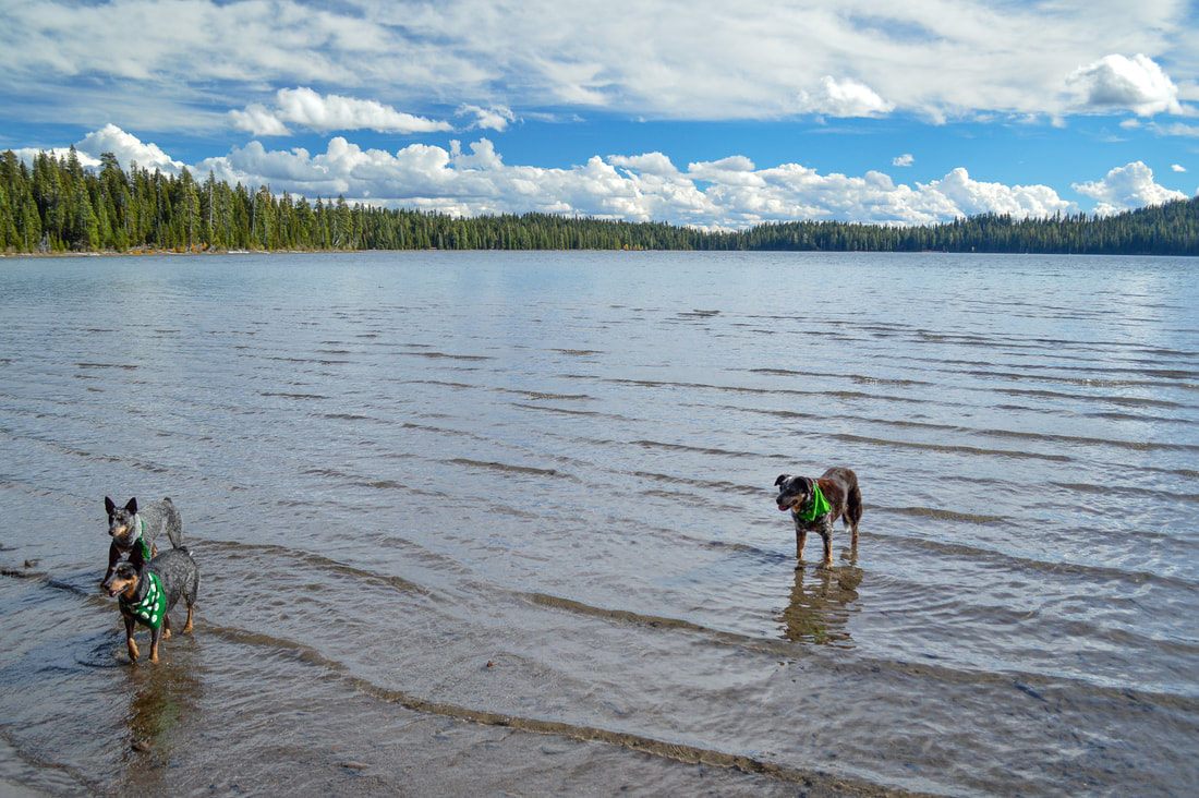
Trail allows: Dogs, horses, camping
Possible dangers: N/A
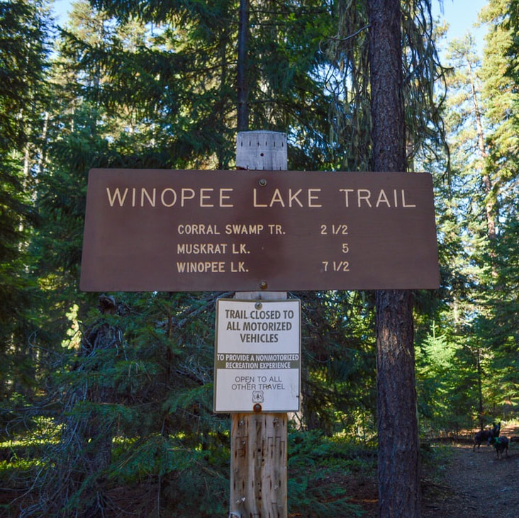
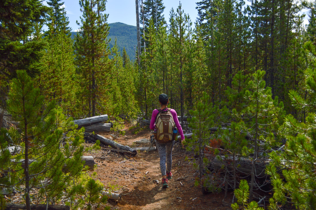
Winopee Lake Trail sign at trailhead

Description:

The Winopee Lake Trail #16 is one of those lesser known trails in Central Oregon that leads to many beautiful hidden lakes and is a frequently overlooked backpacking option into the Three Sisters Wilderness. To do a moderate day hike to Teddy Lakes and Muskrat Lake, start at the Winopee Lake trailhead. There is no pit toilet at the trailhead, but you can use the pit toilet at the campground on the way in. The first 0.8 miles take you along the edge of Cultus Lake. After the resort closes in September, it is very quiet on the lake. There are three boat-in primitive campgrounds along the lake and you can camp here as a hiker as well. The first beach and primitive campsite you will come to is Cultus Cove.
Cultus Lake
(Cultus Lake)
Cultus Lake Cove boat in camp
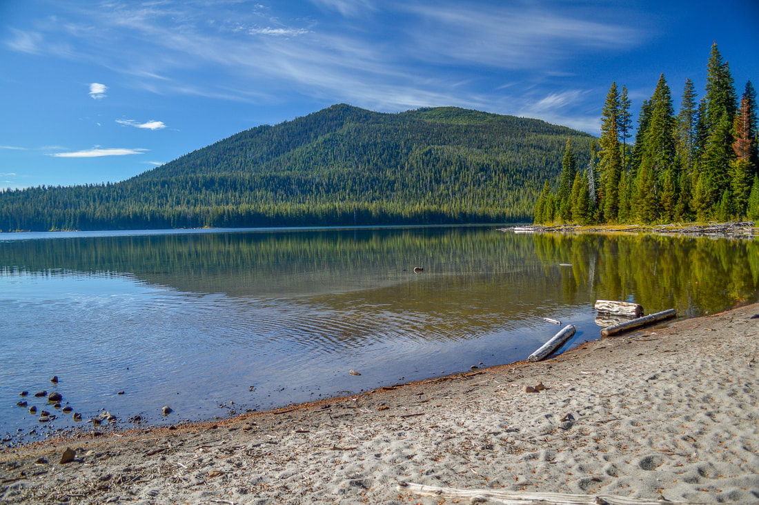
(Cultus Cove & Cultus Mountain)
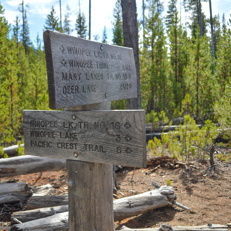
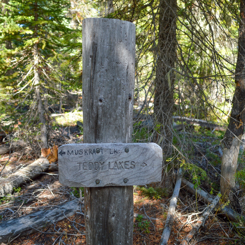
After checking out Cultus Cove with a view of Cultus Mountain across the lake, the trail takes you another 1.6 miles, partially along the lake and through the forest until you see a trail junction. The trail to the right is the Metolious-Windigo Trail #99. Continue straight and after 0.2 miles you will see another trail junction. The trail to the left is the Many Lakes Trail #13 and this trail takes you to Deer Lake and Little Cultus Lake. Continue straight on the Winopee Trail #16 through a forest of very small lodgepole pines, for another 0.7 miles until you see a sign for Teddy Lakes.
Many Lakes trail sign along the Winopee Lake Trail
Winopee Lake Trail
(an example of what the trail tread looks like)
Teddy Lakes trail sign
Teddy Lakes is a set of two small lakes along a short 1 mile out and back trail. These lakes are beautiful but due to the amount of down trees around the lakes they don't make for great camping or swimming destinations. You can fish here and you will find rainbow trout in both of the lakes. After doing the short 1 mile side trip to Teddy Lakes, continue on the Winopee Lake Trail for another 1.2 miles to Muskrat Lake. 
Teddy Lake
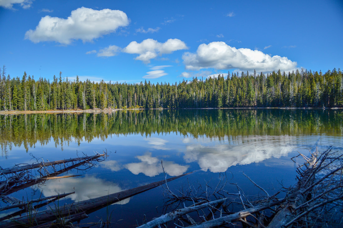
(the larger of the two Teddy Lakes)
Muskrat Lake Shelter
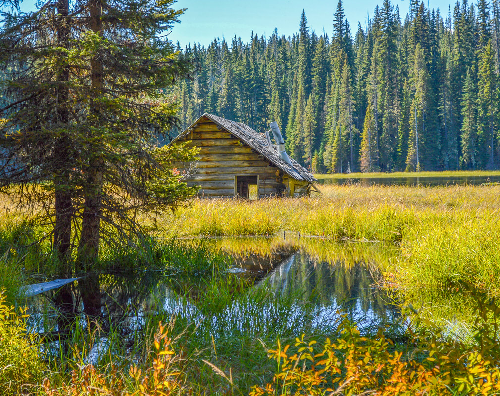
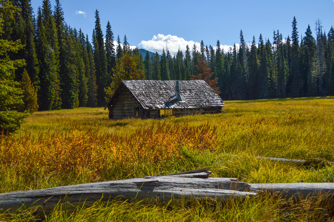
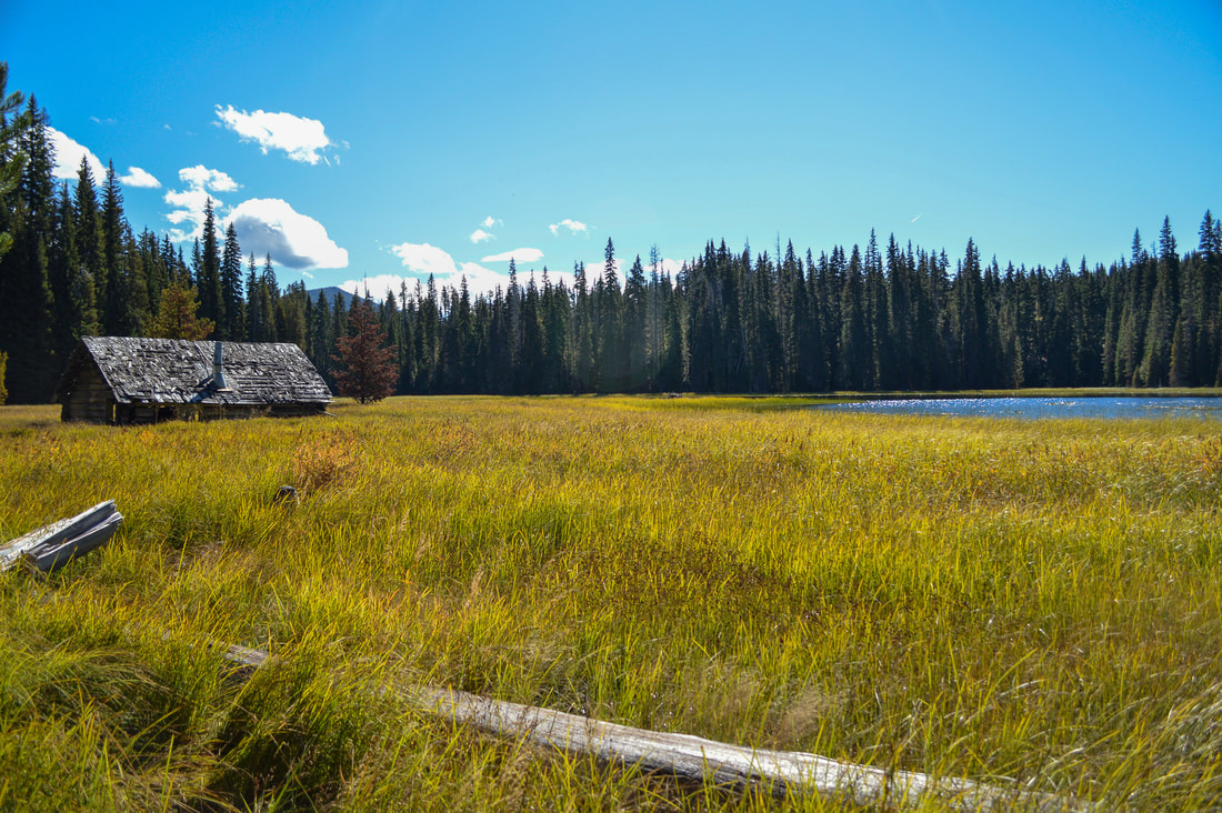
(Muskrat Lake cabin - this cabin has broken down a lot more since this picture in 2016)
Muskrat Lake shelter was built by a trapper who was likely hunting beaver here, not muskrat. You can see signs of active beaver all around this lake. They actually built a dam that raised the lake 4 feet, which ultimately flooded the cabin. It now sits a few feet under water and continues to collapse with every passing year of wind and snow. It is a beautiful sight of nature reclaiming this once inhabited place. There are plenty of flat and open places to set up tents by Muskrat Lake. Because of its marshy nature, the lake is really difficult to fish in unless you have gators with you and can stand in the vegetation of the lake, but the brook trout you will find here are usually between 8 - 15 inches. If you are backpacking and want to add some mileage to your hike, you can keep going on the Winopee Lake Trail for another 2.4 miles to beautiful large Winopee Lake. This lake also has a lot of plant life along its shores, but there are some gorgeous camp spots here.
Muskrat Lake shelter in swamp
The Winopee Lake Trail is relatively flat and is perfect for those looking for solitude in the southern end of the Three Sisters Wilderness. Because the trail is easy and beautiful it's also the perfect place to take kids on their first backpacking trip. There is no exposure or rocky areas along this trail, and the only things to watch out for are possible blowdowns to step over or small roots in the trail. The only reason this trail is rated 'moderate' is because of the mileage. Enjoy this hike in the early fall months when the mosquitoes are gone and Cultus Lake is quiet and calm without boats. You will not regret checking out this hidden Oregon gem.
Muskrat Lake

Directions:

From Bend
  • ​Drive on US-97 south for 14.3 miles, then take exit 153 for S Century Dr toward Sunriver. Turn right onto S Century Dr/Lava Cast Forest Rd/NF-9720 (signs for Sunriver/Mt Bachelor) for 1.5 miles, and at the traffic circle, take the 2nd exit and stay on S Century Dr. for 0.6 miles. Continue onto Spring River Rd. for 2.4 miles, then continue straight onto Conklin Rd/NF-40 for 1.7 miles. Turn left onto Upper Deschutes Rd. for 5 miles, then Upper Deschutes Rd. turns slightly right and becomes 3 Trapper Rd/NF-40, stay on this road for 10 miles. Turn left onto Cascade Lakes National Scenic Byway/Lava Lake Rd. for 1.2 miles, then turn right onto NF-4635 at a sign for Cultus Lake Campground & Resort. After 2 miles make a slight right onto Forest Service Rd. 4635 for half a mile and then right after the campground continue straight onto Forest Service Rd. 120 for 0.1 miles and find the trailhead on your left right before the end of the spur road. (Total of 40 miles)
From Eugene
  • Drive on OR-58 east for a total of 72.7 miles, then turn left onto turn left onto Cascade Lakes National Scenic Byway/Crescent Cutoff Rd/NF-61 for 3.2 miles. At a sign turn left onto Cascade Lakes National Scenic Byway/NF-46 and stay on this road for 24.5 miles. At a sign for Cultus Lake Campground & Resort turn left. After 2 miles make a slight right onto Forest Service Rd. 4635 for half a mile and then right after the campground continue straight onto Forest Service Rd. 120 for 0.1 miles and find the trailhead on your left right before the end of the spur road. (Total of 111 miles)
From Medford
  • ​Take OR-62 east towards Crater Lake for 49.5 miles then take a slight left onto OR-230 north for 23.8 miles. Near Diamond Lake turn right onto OR-138 east for 17.7 miles until it T’s into highway 97. Turn left onto US-97 north for 17.8 miles then use the left lane to take the OR-58 W exit toward Eugene. Continue on OR-58 for 13.1 miles and then turn right onto Cascade Lakes National Scenic Byway/Crescent Cutoff Rd/NF-61 for 3.2 miles. At a sign turn left onto Cascade Lakes National Scenic Byway/NF-46 and stay on this road for 24.5 miles. At a sign for Cultus Lake Campground & Resort turn left. After 2 miles make a slight right onto Forest Service Rd. 4635 for half a mile and then right after the campground continue straight onto Forest Service Rd. 120 for 0.1 miles and find the trailhead on your left right before the end of the spur road. (Total of 160 miles)
From Salem
  • Total of 172 miles via Eugene.
From Portland
  • ​Total of 215 miles via Eugene. 
To get a more in-depth and personal view of this hike, watch the YouTube video.
*All pictures are taken by Franziska Weinheimer
*Disclaimer: The trail descriptions, mileage, GPS tracks and difficulty ratings depicted on this website are never 100% accurate. Always hike at your own risk, using your own knowledge, equipment and common sense. Franziska Weinheimer/Hike Oregon are not responsible if you or anyone in your party gets injured or lost while attempting one of these or any other hikes.

HIKED HERE RECENTLY? PLEASE LEAVE A TRIP REPORT BELOW:

© Hike Oregon 2023
P.O. Box 41911
​Eugene, OR 97404
Proudly powered by Weebly
  • Home
  • *Store*
  • About the author
  • How to use this site
  • Resources
    • Wildflowers
    • Videos
  • Best Oregon Hikes
    • Top Fall Foliage Hikes In Oregon
    • Top 10 Oregon Fall Hikes
    • 20 Best Oregon Waterfall Hikes
    • Top 10 Oregon Hikes for Kids
    • Sno-Parks In Central Oregon
    • Top 10 Oregon Winter Hikes
    • Top Low Elevation Winter Hikes
    • 9 Amazing Oregon Summit Hikes
    • 20 Central Oregon Day Hikes
    • 20 Epic Oregon Wildflower Hikes
    • 5 Weekend Backpacking Trips in Oregon
    • Top One Night Backpacking Trips in Oregon
    • Top 10 Oregon Summer Hikes
    • Top 10 Swimming Spots In Oregon
    • Top 10 Oregon Spring Hikes
  • Oregon Sno-Parks
    • Maxwell Sno-Park
    • Potato Hill Sno-Park
    • Ray Benson Sno-Park
      • Brandenburg Shelter
    • Santiam Sno-Park
    • Three Creek Sno-Park
    • Virginia Meissner Sno-Park
      • Meissner Shelter Loop
      • Nordeen Shelter
    • Gold Lake Sno-Park
      • Westview Shelter to Eagle Rock Overlook
      • Marilyn Lakes Loop
  • Southern Washington
    • Hamilton Mountain
    • Dog Mountain
    • Coyote Wall
    • Mount St. Helens
  • Portland
    • Powell Butte
    • Forest Park
    • Latourell Falls
    • Multnomah/Wahkeena Falls
    • Eagle Creek
    • Mitchell Point
    • Table Rock
    • Tamanawas Falls
    • Trillium Lake
    • East Zigzag Mountain (members only)
  • Salem
    • Abiqua Falls
    • Silver Falls State Park
    • Dome Rock
    • Marion Lake to Marion Mountain
    • Jefferson Park
  • Corvallis
    • Marys Peak East Ridge
    • Marys Peak North Ridge
    • Alsea Falls and Green Peak Falls
    • Corvallis to Sea Trail - Sugarbowl Creek segment (members only)
  • Sweet Home
    • Crescent Mountain
    • Iron Mountain
    • McDowell Creek Falls
    • Middle Santiam River (members only)
    • Lower Soda Creek Falls (members only)
    • Rooster Rock (members only)
  • McKenzie Bridge/Blue River
    • Macduff Mountain
    • Proxy Falls
    • Clear Lake
    • Sahalie/Koosah Falls
    • Blue Pool
    • Erma Bell Lakes
    • Olallie Mountain
    • Horsepasture Mountain
    • Tidbits Mountain
    • Castle Rock
    • Lowder Mountain (members only)
    • East Fork Trail (members only)
    • Rainbow Falls Overlook (members only)
    • Frissell Point (members only)
    • Chucksney Mountain (members only)
    • Substitute Point (members only)
  • Sisters/Santiam Pass
    • Coffin Mountain
    • Trappers Butte and Scar Mountain
    • Maxwell Butte
    • Black Butte
    • Whychus Creek Trail
    • Tam McArthur Rim
    • Black Crater
    • Scott Mountain
    • Obsidian Trail
    • Metolius Preserve
    • Three Fingered Jack Loop
    • Square Lake
    • Canyon Creek Meadows
    • Patjens Lakes
    • Craig Lake (members only)
    • Chush Falls (members only)
    • Rockpile Lake (members only)
    • Santiam Lake (members only)
    • Camp Lake (members only)
    • Park Meadow to Golden Lake (members only)
  • Bend/Redmond/LaPine
    • Steins Pillar
    • Chimney Rock
    • Steelhead Falls
    • Tumalo State Park
    • Tumalo Falls
    • Tumalo Mountain
    • No Name Lake
    • Green Lakes
    • Moraine Lake
    • South Sister Summit
    • Horse Lake
    • Muskrat Lake
    • Paulina Peak
    • Peter Skene Ogden Trail (members only)
  • Eugene
    • Ridgeline Trail
    • Mount Pisgah Summit
    • Mount Pisgah Arboretum
    • Shotgun Creek
    • Mount June
    • Lawler
    • Tire Mountain
    • Goodman Creek
    • Brice Creek
    • Trestle Creek Falls
    • Moon Falls
    • Elijah Bristow State Park
    • South Willamette Trail (members only)
    • Eula Ridge (members only)
    • Eagle's Rest (members only)
  • Oakridge
    • Deception Creek
    • North Salmon Creek
    • Grasshopper Ridge
    • Larison Creek
    • Bunchgrass Ridge
    • Salt Creek Falls
    • Waldo Lake Loop
    • South Waldo Loop
    • The Twins
    • Rosary Lakes
    • Yoran Lake
    • Fawn Lake
    • Windy Lakes
    • Divide Lake
    • Diamond Peak Summit
    • Cowhorn Mountain
    • Wall Creek Warm Springs (members only)
    • Moon Point (members only)
    • Bobby Lake (members only)
    • Lillian Falls (members only)
    • Middle Fork Willamette Trail (members only)
    • Pool Creek Falls (members only)
    • Dead Mountain (members only)
    • Larison Rock (members only)
    • Quinn Lakes & Eddeeleo Lakes (members only)
    • Waldo Mountain Lookout (members only)
    • Blair Lake to Spring Prairie (members only)
    • Rigdon Lakes loop (members only)
  • Oregon Coast
    • Cascade Head
    • Drift Creek Falls
    • Sweet Creek Falls
    • Beaver Creek Falls
    • Kentucky Falls
    • Hobbit Trail to Heceta Head
    • Valley Trail to China Creek
    • North Fork Smith River (members only)
    • Cummins Ridge (member's only)
    • Horse Creek (members only)
    • Siltcoos Lake (members only)
  • Southern Oregon
    • Fall Creek Falls
    • Watson Falls
    • Wild Rogue Loop
    • Mt. Thielsen
    • Crater Lake National Park
      • The Watchman
      • Mount Scott
      • The Pinnacles
    • Lower Table Rock
    • Pilot Rock
    • Wagner Butte
    • Mt. McLoughlin
    • Lemolo Falls (members only)
    • Fern Falls (members only)
  • Eastern Oregon
    • Painted Cove
    • Anthony Lake Loop
    • Mount Howard
    • Eagle Cap summit
    • Schneider Cabin (members only)
    • Strawberry Lake & Strawberry Falls (members only)
  • Oregon PCT sections
  • Tips & Tricks
    • Leave No Trace
    • How To Pick The Right Backpacking Tent
    • Top Tips For Hiking With Infants And Toddlers
    • Poison Oak, Ivy and Sumac
    • How to dress for cold weather hikes
    • Outdoorsy Holiday Gift Guide 2022
    • Hiker Holiday Gift Guide 2019
    • Outdoor Holiday Gift Guide 2018
    • Hiking Holiday Gift Guide 2017
  • Reviews/Gear
    • Stay Kühl This Summer
    • Outdoor Herbivore Backpacking Food Review
    • Osprey Aura AG 65 Backpack review
    • Big Agnes Fly Creek UL2 review
    • REI Quarter Dome 1 review
  • Adventure Stories
    • Hiking The Rae Lakes Loop
    • 110 Miles on the PCT
    • Three Fingered Jack Adventures
    • Jefferson Wilderness