Hike Oregon
  • Home
  • *Store*
  • About the author
  • How to use this site
  • Resources
    • Wildflowers
    • Videos
  • Best Oregon Hikes
    • Top Fall Foliage Hikes In Oregon
    • Top 10 Oregon Fall Hikes
    • 20 Best Oregon Waterfall Hikes
    • Top 10 Oregon Hikes for Kids
    • Sno-Parks In Central Oregon
    • Top 10 Oregon Winter Hikes
    • Top Low Elevation Winter Hikes
    • 9 Amazing Oregon Summit Hikes
    • 20 Central Oregon Day Hikes
    • 20 Epic Oregon Wildflower Hikes
    • 5 Weekend Backpacking Trips in Oregon
    • Top One Night Backpacking Trips in Oregon
    • Top 10 Oregon Summer Hikes
    • Top 10 Swimming Spots In Oregon
    • Top 10 Oregon Spring Hikes
  • Oregon Sno-Parks
    • Maxwell Sno-Park
    • Potato Hill Sno-Park
    • Ray Benson Sno-Park
      • Brandenburg Shelter
    • Santiam Sno-Park
    • Three Creek Sno-Park
    • Virginia Meissner Sno-Park
      • Meissner Shelter Loop
      • Nordeen Shelter
    • Gold Lake Sno-Park
      • Westview Shelter to Eagle Rock Overlook
      • Marilyn Lakes Loop
  • Southern Washington
    • Hamilton Mountain
    • Dog Mountain
    • Coyote Wall
    • Mount St. Helens
  • Portland
    • Powell Butte
    • Forest Park
    • Latourell Falls
    • Multnomah/Wahkeena Falls
    • Eagle Creek
    • Mitchell Point
    • Table Rock
    • Tamanawas Falls
    • Trillium Lake
    • East Zigzag Mountain (members only)
  • Salem
    • Abiqua Falls
    • Silver Falls State Park
    • Dome Rock
    • Marion Lake to Marion Mountain
    • Jefferson Park
  • Corvallis
    • Marys Peak East Ridge
    • Marys Peak North Ridge
    • Alsea Falls and Green Peak Falls
    • Corvallis to Sea Trail - Sugarbowl Creek segment (members only)
  • Sweet Home
    • Crescent Mountain
    • Iron Mountain
    • McDowell Creek Falls
    • Middle Santiam River (members only)
    • Lower Soda Creek Falls (members only)
    • Rooster Rock (members only)
  • McKenzie Bridge/Blue River
    • Macduff Mountain
    • Proxy Falls
    • Clear Lake
    • Sahalie/Koosah Falls
    • Blue Pool
    • Erma Bell Lakes
    • Olallie Mountain
    • Horsepasture Mountain
    • Tidbits Mountain
    • Castle Rock
    • Lowder Mountain (members only)
    • East Fork Trail (members only)
    • Rainbow Falls Overlook (members only)
    • Frissell Point (members only)
    • Chucksney Mountain (members only)
    • Substitute Point (members only)
  • Sisters/Santiam Pass
    • Coffin Mountain
    • Trappers Butte and Scar Mountain
    • Maxwell Butte
    • Black Butte
    • Whychus Creek Trail
    • Tam McArthur Rim
    • Black Crater
    • Scott Mountain
    • Obsidian Trail
    • Metolius Preserve
    • Three Fingered Jack Loop
    • Square Lake
    • Canyon Creek Meadows
    • Patjens Lakes
    • Craig Lake (members only)
    • Chush Falls (members only)
    • Rockpile Lake (members only)
    • Santiam Lake (members only)
    • Camp Lake (members only)
    • Park Meadow to Golden Lake (members only)
  • Bend/Redmond/LaPine
    • Steins Pillar
    • Chimney Rock
    • Steelhead Falls
    • Tumalo State Park
    • Tumalo Falls
    • Tumalo Mountain
    • No Name Lake
    • Green Lakes
    • Moraine Lake
    • South Sister Summit
    • Horse Lake
    • Muskrat Lake
    • Paulina Peak
    • Peter Skene Ogden Trail (members only)
  • Eugene
    • Ridgeline Trail
    • Mount Pisgah Summit
    • Mount Pisgah Arboretum
    • Shotgun Creek
    • Mount June
    • Lawler
    • Tire Mountain
    • Goodman Creek
    • Brice Creek
    • Trestle Creek Falls
    • Moon Falls
    • Elijah Bristow State Park
    • South Willamette Trail (members only)
    • Eula Ridge (members only)
    • Eagle's Rest (members only)
  • Oakridge
    • Deception Creek
    • North Salmon Creek
    • Grasshopper Ridge
    • Larison Creek
    • Bunchgrass Ridge
    • Salt Creek Falls
    • Waldo Lake Loop
    • South Waldo Loop
    • The Twins
    • Rosary Lakes
    • Yoran Lake
    • Fawn Lake
    • Windy Lakes
    • Divide Lake
    • Diamond Peak Summit
    • Cowhorn Mountain
    • Wall Creek Warm Springs (members only)
    • Moon Point (members only)
    • Bobby Lake (members only)
    • Lillian Falls (members only)
    • Middle Fork Willamette Trail (members only)
    • Pool Creek Falls (members only)
    • Dead Mountain (members only)
    • Larison Rock (members only)
    • Quinn Lakes & Eddeeleo Lakes (members only)
    • Waldo Mountain Lookout (members only)
    • Blair Lake to Spring Prairie (members only)
    • Rigdon Lakes loop (members only)
  • Oregon Coast
    • Cascade Head
    • Drift Creek Falls
    • Sweet Creek Falls
    • Beaver Creek Falls
    • Kentucky Falls
    • Hobbit Trail to Heceta Head
    • Valley Trail to China Creek
    • North Fork Smith River (members only)
    • Cummins Ridge (member's only)
    • Horse Creek (members only)
    • Siltcoos Lake (members only)
  • Southern Oregon
    • Fall Creek Falls
    • Watson Falls
    • Wild Rogue Loop
    • Mt. Thielsen
    • Crater Lake National Park
      • The Watchman
      • Mount Scott
      • The Pinnacles
    • Lower Table Rock
    • Pilot Rock
    • Wagner Butte
    • Mt. McLoughlin
    • Lemolo Falls (members only)
    • Fern Falls (members only)
  • Eastern Oregon
    • Painted Cove
    • Anthony Lake Loop
    • Mount Howard
    • Eagle Cap summit
    • Schneider Cabin (members only)
    • Strawberry Lake & Strawberry Falls (members only)
  • Oregon PCT sections
  • Tips & Tricks
    • Leave No Trace
    • How To Pick The Right Backpacking Tent
    • Top Tips For Hiking With Infants And Toddlers
    • Poison Oak, Ivy and Sumac
    • How to dress for cold weather hikes
    • Outdoorsy Holiday Gift Guide 2022
    • Hiker Holiday Gift Guide 2019
    • Outdoor Holiday Gift Guide 2018
    • Hiking Holiday Gift Guide 2017
  • Reviews/Gear
    • Stay Kühl This Summer
    • Outdoor Herbivore Backpacking Food Review
    • Osprey Aura AG 65 Backpack review
    • Big Agnes Fly Creek UL2 review
    • REI Quarter Dome 1 review
  • Adventure Stories
    • Hiking The Rae Lakes Loop
    • 110 Miles on the PCT
    • Three Fingered Jack Adventures
    • Jefferson Wilderness

Painted Cove

​
Get the printable version of this hike

Hike details:

Mileage: 0.25 miles out and back w/ 50 ft. elevation gain
Approximate hike time: 25 - 30 minutes so that you can take the time to read all of the plaques and learn about the area.
Difficulty: Very easy
Trail usage: High on weekends in the summer, medium on weekends in the fall, winter and spring, medium on weekdays in the spring, low on weekdays in the fall, winter and spring.
Highest elevation: 1,925 ft. Lowest elevation: 1,875 ft.
General location: 70 miles northeast of Redmond - John Day Fossil Beds National Monument
Suggested seasons: Fall, winter, spring, summer (although summer is going to be hot)
(Best time to go during the spring is March, April and early May. Avoid summer months June, July August because it gets very hot and is not as enjoyable. Fall months are great as well September, October, November and early December. It can snow sometimes in late December, January and February and the roads can be icy).
Permits required: N/A
Pit toilet at trailhead: No (but there is one at the picnic area on the way in)
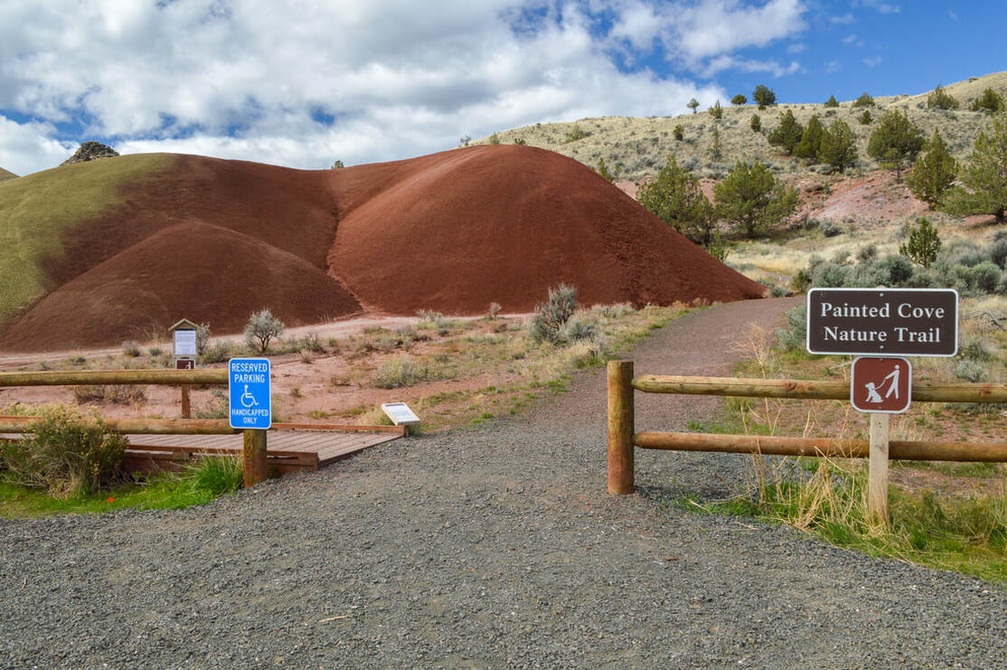
Trail allows: ​Dogs, wheelchairs 
Possible dangers: ​N/A
Painted Cove Nature Trail trailhead

Description:

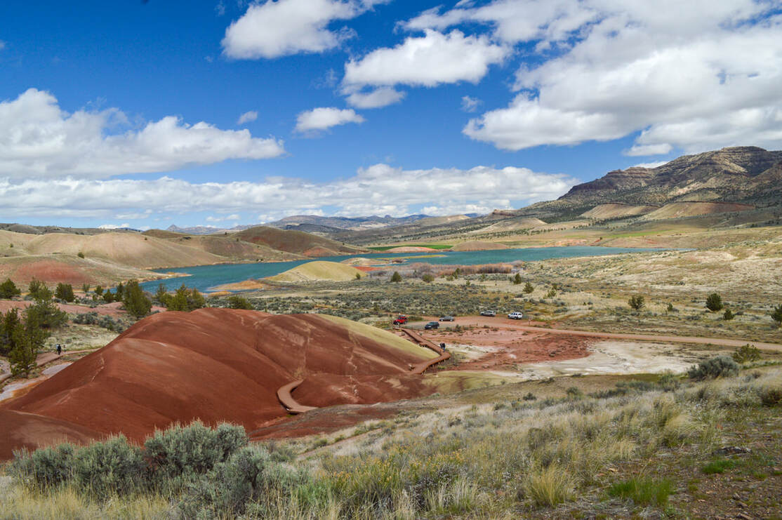
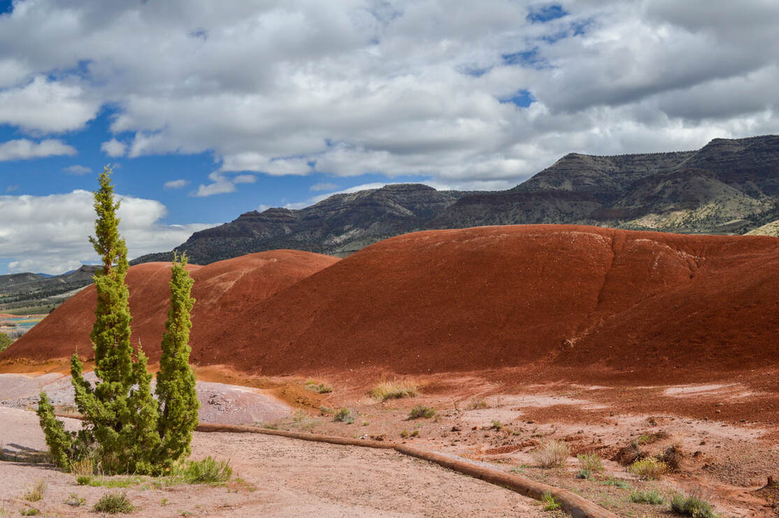
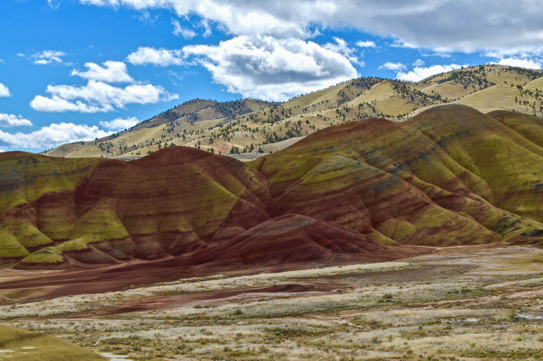
The John Day Fossil Beds National Monument has a lot to offer and because there are various units of the monument spread throughout the area, you could really spend a few days here discovering all of the trails and surrounding beauty and vast history of this incredibly unique place. The Painted Hills are one of the 7 Wonders of Oregon and the short loop trail through Painted Cove is definitely worth the stop. 
Painted Cove boardwalk
Most people do the loop clockwise, but you can go either way. There are a total of 10 plaques along the way that tell the story of how these painted hills were formed. A big reminder, DO NOT step off the trail/boardwalk and onto the hills. Footprints will scar them and quicken the erosion. Every year the painted hills erode away a little bit with the rain. 

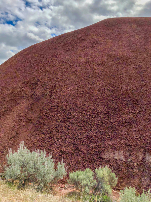
​Text from the plaque: Red and yellow clay layers mark different paleo environments. Red soils indicate a warm, wet period where swamps were common. Yellow clays point to a cooler, drier time dominated by hardwood forests. 
Entering Painted Cove red hills
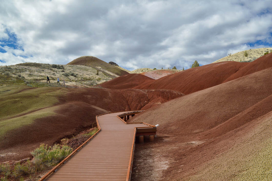
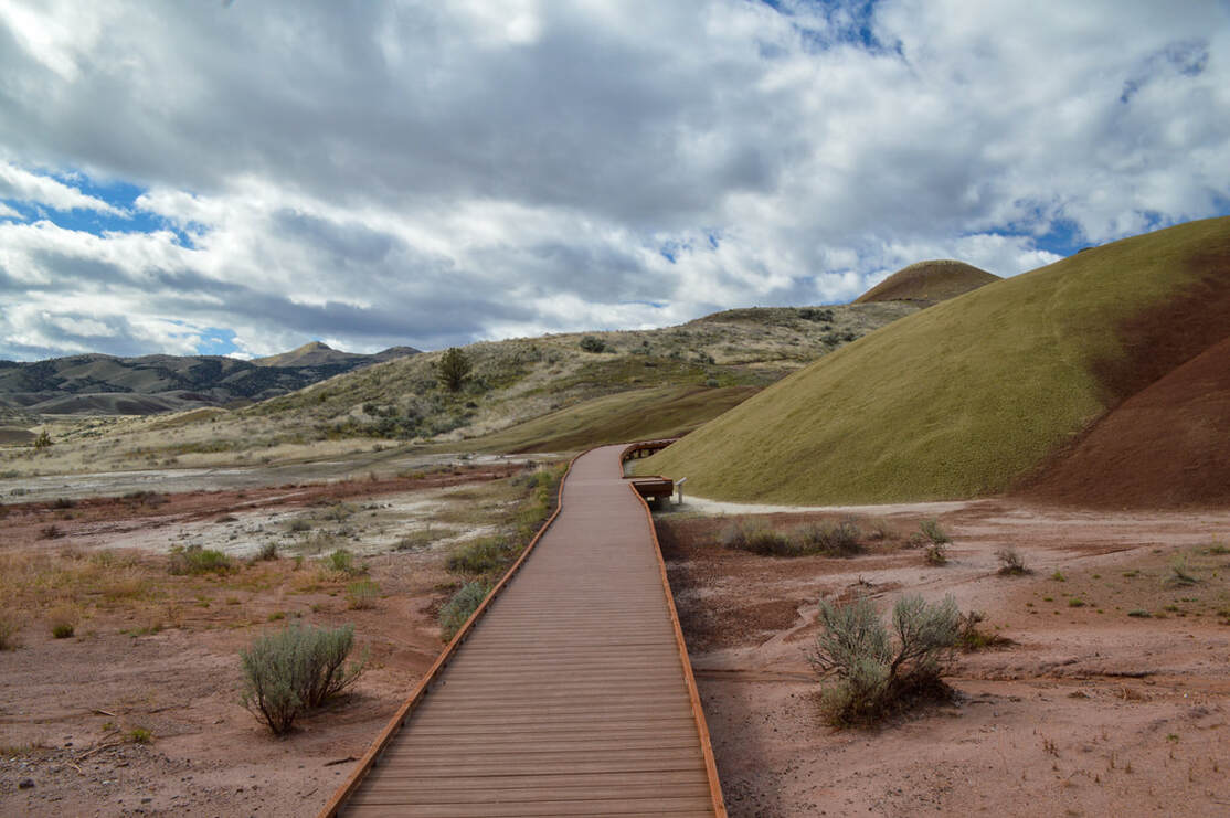
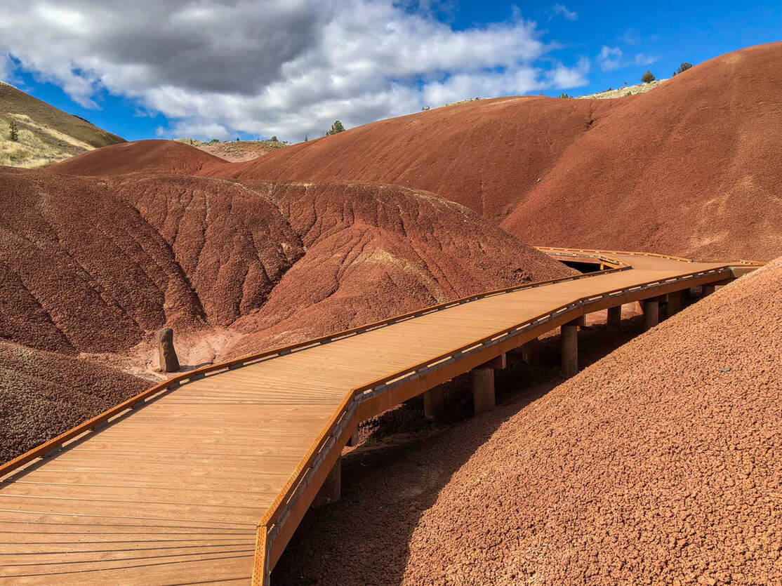
As you enter into the hills there is a boardwalk built for very easy walking and wheelchair accessibility. Walking along the boardwalk is absolutely amazing as you go deeper into the hills. In the spring, flowers bloom along the sides of the walkway and there are many places where you can admire the texture and colors of the hills close up.

​​Text from the plaque: Volcanic ash along with organic debris from nearby hardwood forests washed into swampy basins, eventually forming water-logged soils in ancient wetlands. How did these slimy black swamp soils turn red?  
Painted Hills trail with boardwalk
Text from the plaque: Like old metal, the hills are slowly oxidizing or rusting. About 33 million years ago, iron rich volcanic ash fell on this landscape. Weathering processes slowly changed new ash layers into fertile soils under forests and swamps. Over time, oxidizing irons stained the clay soils, forming the rusting red hills you see today.
Red Painted Hills Painted Cove Trail
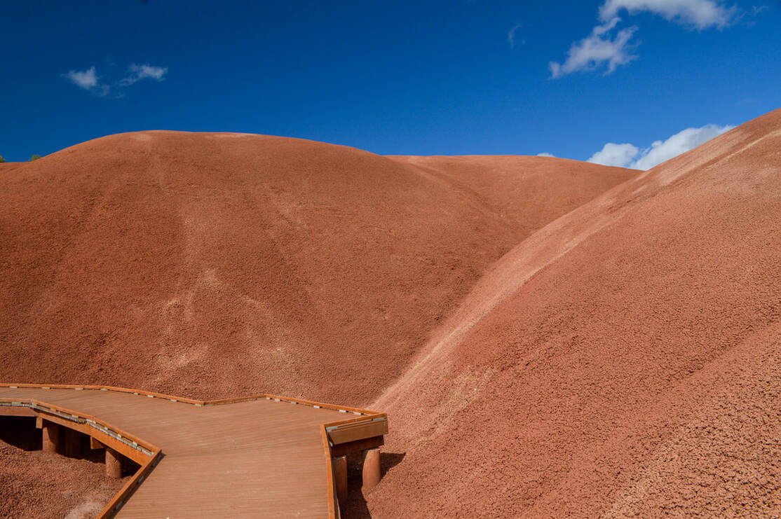
After walking through the hills, the boardwalk ends and there is a small gravel path that you can take that goes up a short hill to a viewpoint. From the viewpoint you can see above Painted Cove and you will also see the larger Painted Hills in the distance to the south. 

​Text from the plaque: The ultimate sculptor, water carves away soft sediments made of tiny clay particles in the dry desert landscape. Sinkholes can mark the start of underground tunnels and waterways cut by flowing water carrying away fine clay particles. 
Painted Cove Trail viewpoint to the north
Text from the plaque: Minerals in eroded clays yield warm reds, yellows, and oranges as the blend of iron and magnesium oxides break down or rust. Remnants of a rhyolitic lava flow glimmer with lavender colors. The Rhyolitic lava flow is part of the Clarno Formation - an older rock layer buried under the Painted Hills. Sticky and thick, rhyolitic lava travels slowly. The source of this flow was probably very close to here. 
Trees at the Painted Hills
After checking out the viewpoint, you will circle around to the left and walk along the path on the outside of the Painted Cove. The stark contrast of the green plants, the red hills and (on most days) the blue skies is absolutely striking! After circling around the outside, you will arrive back at the parking lot. 
Overall, this very short and easy loop through Painted Cove is a must-see stop on your way through the area. On your way out, make sure to stop in the cute town of Mitchell! Whether you're getting a burger and brew at Tiger Town Brewery, delicious baked goods, cakes and pies at Painted Hills Pastry, or buying a cold soda, a souvenir t-shirt or just a candy bar at the Wheeler County Trading Company, Mitchell has something for everything and it's a town that you don't want to miss!
Close up of the Painted Hills texture
Painted Cove Trail viewpoint to the south

Directions:

From Bend
  • ​Drive US-97 north toward Redmond for 15.2 miles, then turn right onto SW Veterans Way for 0.6 miles and then stay to the left onto SE Veterans Way for 0.8 miles. Turn right OR-126 E for 14.4 miles, then at the traffic circle, take the 2nd exit and stay on OR-126 E for another 2.3 miles. In the town of Prineville merge onto US-26 E/NW 3rd St. and stay on this road through town for a total of 44.3 miles. Turn left onto Bridge Creek Rd/Burnt Ranch Rd. for 5.6 miles, then turn left onto Bear Creek Rd. for 1.8 miles and finally turn right at a sign for Painted Cove and continue 0.4 miles to the trailhead. (Total of 86.5 miles)
From Portland
  • ​Drive US-26 east towards Madras for 103 miles. After driving through the town of Madras stay left to continue on US-26 east for another 25.8 miles. In Prineville turn left onto NW 9th St. for 0.8 miles, then turn right onto NE Main St. and after one block turn left onto NE 7th St. for 0.6 miles. Continue onto NE Laughlin Rd. for 1.3 miles, then turn left onto US-26 E/NE 3rd St. for 41.9 miles. Turn left onto Bridge Creek Rd/Burnt Ranch Rd. for 5.6 miles, then turn left onto Bear Creek Rd. for 1.8 miles and finally turn right at a sign for Painted Cove and continue 0.4 miles to the trailhead. (Total of 200 miles)
From Eugene
  • It is a total of 207 miles via Sisters & Redmond (via Sweet Home due to the OR-126 fire closure).
From Salem
  • It is a total of 214 miles via Bend (via Sweet Home due to the OR-22 fire closure).
From Medford
  • It is a total of 259 miles via Bend.
-This trail write-up was last updated June, 2022-
*All pictures are taken by Franziska Weinheimer
*Disclaimer: The trail descriptions, mileage, GPS tracks and difficulty ratings depicted on this website are never 100% accurate. Always hike at your own risk, using your own knowledge, equipment and common sense. Franziska Weinheimer/Hike Oregon are not responsible if you or anyone in your party gets injured or lost while attempting one of these or any other hikes.

HIKED HERE RECENTLY? PLEASE LEAVE A TRIP REPORT BELOW:

© Hike Oregon 2023
P.O. Box 41911
​Eugene, OR 97404
Proudly powered by Weebly
  • Home
  • *Store*
  • About the author
  • How to use this site
  • Resources
    • Wildflowers
    • Videos
  • Best Oregon Hikes
    • Top Fall Foliage Hikes In Oregon
    • Top 10 Oregon Fall Hikes
    • 20 Best Oregon Waterfall Hikes
    • Top 10 Oregon Hikes for Kids
    • Sno-Parks In Central Oregon
    • Top 10 Oregon Winter Hikes
    • Top Low Elevation Winter Hikes
    • 9 Amazing Oregon Summit Hikes
    • 20 Central Oregon Day Hikes
    • 20 Epic Oregon Wildflower Hikes
    • 5 Weekend Backpacking Trips in Oregon
    • Top One Night Backpacking Trips in Oregon
    • Top 10 Oregon Summer Hikes
    • Top 10 Swimming Spots In Oregon
    • Top 10 Oregon Spring Hikes
  • Oregon Sno-Parks
    • Maxwell Sno-Park
    • Potato Hill Sno-Park
    • Ray Benson Sno-Park
      • Brandenburg Shelter
    • Santiam Sno-Park
    • Three Creek Sno-Park
    • Virginia Meissner Sno-Park
      • Meissner Shelter Loop
      • Nordeen Shelter
    • Gold Lake Sno-Park
      • Westview Shelter to Eagle Rock Overlook
      • Marilyn Lakes Loop
  • Southern Washington
    • Hamilton Mountain
    • Dog Mountain
    • Coyote Wall
    • Mount St. Helens
  • Portland
    • Powell Butte
    • Forest Park
    • Latourell Falls
    • Multnomah/Wahkeena Falls
    • Eagle Creek
    • Mitchell Point
    • Table Rock
    • Tamanawas Falls
    • Trillium Lake
    • East Zigzag Mountain (members only)
  • Salem
    • Abiqua Falls
    • Silver Falls State Park
    • Dome Rock
    • Marion Lake to Marion Mountain
    • Jefferson Park
  • Corvallis
    • Marys Peak East Ridge
    • Marys Peak North Ridge
    • Alsea Falls and Green Peak Falls
    • Corvallis to Sea Trail - Sugarbowl Creek segment (members only)
  • Sweet Home
    • Crescent Mountain
    • Iron Mountain
    • McDowell Creek Falls
    • Middle Santiam River (members only)
    • Lower Soda Creek Falls (members only)
    • Rooster Rock (members only)
  • McKenzie Bridge/Blue River
    • Macduff Mountain
    • Proxy Falls
    • Clear Lake
    • Sahalie/Koosah Falls
    • Blue Pool
    • Erma Bell Lakes
    • Olallie Mountain
    • Horsepasture Mountain
    • Tidbits Mountain
    • Castle Rock
    • Lowder Mountain (members only)
    • East Fork Trail (members only)
    • Rainbow Falls Overlook (members only)
    • Frissell Point (members only)
    • Chucksney Mountain (members only)
    • Substitute Point (members only)
  • Sisters/Santiam Pass
    • Coffin Mountain
    • Trappers Butte and Scar Mountain
    • Maxwell Butte
    • Black Butte
    • Whychus Creek Trail
    • Tam McArthur Rim
    • Black Crater
    • Scott Mountain
    • Obsidian Trail
    • Metolius Preserve
    • Three Fingered Jack Loop
    • Square Lake
    • Canyon Creek Meadows
    • Patjens Lakes
    • Craig Lake (members only)
    • Chush Falls (members only)
    • Rockpile Lake (members only)
    • Santiam Lake (members only)
    • Camp Lake (members only)
    • Park Meadow to Golden Lake (members only)
  • Bend/Redmond/LaPine
    • Steins Pillar
    • Chimney Rock
    • Steelhead Falls
    • Tumalo State Park
    • Tumalo Falls
    • Tumalo Mountain
    • No Name Lake
    • Green Lakes
    • Moraine Lake
    • South Sister Summit
    • Horse Lake
    • Muskrat Lake
    • Paulina Peak
    • Peter Skene Ogden Trail (members only)
  • Eugene
    • Ridgeline Trail
    • Mount Pisgah Summit
    • Mount Pisgah Arboretum
    • Shotgun Creek
    • Mount June
    • Lawler
    • Tire Mountain
    • Goodman Creek
    • Brice Creek
    • Trestle Creek Falls
    • Moon Falls
    • Elijah Bristow State Park
    • South Willamette Trail (members only)
    • Eula Ridge (members only)
    • Eagle's Rest (members only)
  • Oakridge
    • Deception Creek
    • North Salmon Creek
    • Grasshopper Ridge
    • Larison Creek
    • Bunchgrass Ridge
    • Salt Creek Falls
    • Waldo Lake Loop
    • South Waldo Loop
    • The Twins
    • Rosary Lakes
    • Yoran Lake
    • Fawn Lake
    • Windy Lakes
    • Divide Lake
    • Diamond Peak Summit
    • Cowhorn Mountain
    • Wall Creek Warm Springs (members only)
    • Moon Point (members only)
    • Bobby Lake (members only)
    • Lillian Falls (members only)
    • Middle Fork Willamette Trail (members only)
    • Pool Creek Falls (members only)
    • Dead Mountain (members only)
    • Larison Rock (members only)
    • Quinn Lakes & Eddeeleo Lakes (members only)
    • Waldo Mountain Lookout (members only)
    • Blair Lake to Spring Prairie (members only)
    • Rigdon Lakes loop (members only)
  • Oregon Coast
    • Cascade Head
    • Drift Creek Falls
    • Sweet Creek Falls
    • Beaver Creek Falls
    • Kentucky Falls
    • Hobbit Trail to Heceta Head
    • Valley Trail to China Creek
    • North Fork Smith River (members only)
    • Cummins Ridge (member's only)
    • Horse Creek (members only)
    • Siltcoos Lake (members only)
  • Southern Oregon
    • Fall Creek Falls
    • Watson Falls
    • Wild Rogue Loop
    • Mt. Thielsen
    • Crater Lake National Park
      • The Watchman
      • Mount Scott
      • The Pinnacles
    • Lower Table Rock
    • Pilot Rock
    • Wagner Butte
    • Mt. McLoughlin
    • Lemolo Falls (members only)
    • Fern Falls (members only)
  • Eastern Oregon
    • Painted Cove
    • Anthony Lake Loop
    • Mount Howard
    • Eagle Cap summit
    • Schneider Cabin (members only)
    • Strawberry Lake & Strawberry Falls (members only)
  • Oregon PCT sections
  • Tips & Tricks
    • Leave No Trace
    • How To Pick The Right Backpacking Tent
    • Top Tips For Hiking With Infants And Toddlers
    • Poison Oak, Ivy and Sumac
    • How to dress for cold weather hikes
    • Outdoorsy Holiday Gift Guide 2022
    • Hiker Holiday Gift Guide 2019
    • Outdoor Holiday Gift Guide 2018
    • Hiking Holiday Gift Guide 2017
  • Reviews/Gear
    • Stay Kühl This Summer
    • Outdoor Herbivore Backpacking Food Review
    • Osprey Aura AG 65 Backpack review
    • Big Agnes Fly Creek UL2 review
    • REI Quarter Dome 1 review
  • Adventure Stories
    • Hiking The Rae Lakes Loop
    • 110 Miles on the PCT
    • Three Fingered Jack Adventures
    • Jefferson Wilderness