Hike Oregon
  • Home
  • *Store*
  • About the author
  • How to use this site
  • Resources
    • Wildflowers
    • Videos
  • Best Oregon Hikes
    • 20 Epic Oregon Wildflower Hikes
    • Top 10 Oregon Spring Hikes
    • 20 Best Oregon Waterfall Hikes
    • Top 10 Oregon Hikes for Kids
    • 5 Weekend Backpacking Trips in Oregon
    • Top One Night Backpacking Trips in Oregon
    • Top Fall Foliage Hikes In Oregon
    • Top 10 Oregon Summer Hikes
    • Top 10 Swimming Spots In Oregon
    • Top 10 Oregon Fall Hikes
    • Sno-Parks In Central Oregon
    • Top 10 Oregon Winter Hikes
    • Top Low Elevation Winter Hikes
  • Oregon Sno-Parks
    • Maxwell Sno-Park
    • Potato Hill Sno-Park
    • Ray Benson Sno-Park
      • Brandenburg Shelter
    • Santiam Sno-Park
    • Three Creek Sno-Park
    • Virginia Meissner Sno-Park
      • Meissner Shelter Loop
      • Nordeen Shelter
    • Gold Lake Sno-Park
      • Westview Shelter to Eagle Rock Overlook
      • Marilyn Lakes Loop
  • Portland
    • Powell Butte
    • Forest Park
    • Hamilton Mountain
    • Latourell Falls
    • Multnomah/Wahkeena Falls
    • Dog Mountain
    • Coyote Wall
    • Mitchell Point
    • Table Rock
    • Tamanawas Falls
    • Trillium Lake
    • East Zigzag Mountain (members only)
  • Salem
    • Abiqua Falls
    • Silver Falls State Park
    • Marion Lake to Marion Mountain
    • Jefferson Park
  • Sweet Home
    • Crescent Mountain
    • Iron Mountain
    • McDowell Creek Falls
    • Middle Santiam River (members only)
    • Lower Soda Creek Falls (members only)
    • Rooster Rock (members only)
  • McKenzie Bridge/Blue River
    • Macduff Mountain
    • Proxy Falls
    • Clear Lake
    • Sahalie/Koosah Falls
    • Blue Pool
    • Erma Bell Lakes
    • Olallie Mountain
    • Horsepasture Mountain
    • Tidbits Mountain
    • Castle Rock
    • East Fork Trail (members only)
    • Rainbow Falls Overlook (members only)
    • Frissell Point (members only)
    • Chucksney Mountain (members only)
    • Substitute Point (members only)
  • Sisters/Santiam Pass
    • Coffin Mountain
    • Trappers Butte and Scar Mountain
    • Black Butte
    • Tam McArthur Rim
    • Black Crater
    • Scott Mountain
    • Obsidian Trail
    • Three Fingered Jack Loop
    • Square Lake
    • Canyon Creek Meadows
    • Patjens Lakes
    • Craig Lake (members only)
    • Chush Falls (members only)
    • Rockpile Lake (members only)
    • Santiam Lake (members only)
    • Camp Lake (members only)
    • Park Meadow to Golden Lake (members only)
  • Bend/Redmond/LaPine
    • Steins Pillar
    • Chimney Rock
    • Steelhead Falls
    • Tumalo State Park
    • Tumalo Falls
    • Tumalo Mountain
    • No Name Lake
    • Green Lakes
    • Moraine Lake
    • South Sister Summit
    • Muskrat Lake
    • Paulina Peak
    • Peter Skene Ogden Trail (members only)
  • Eugene
    • Ridgeline Trail
    • Mount Pisgah Summit
    • Mount Pisgah Arboretum
    • Shotgun Creek
    • Mount June
    • Lawler
    • Tire Mountain
    • Goodman Creek
    • Brice Creek
    • Trestle Creek Falls
    • Moon Falls
    • Elijah Bristow State Park
    • South Willamette Trail (members only)
    • Eula Ridge (members only)
    • Eagle's Rest (members only)
  • Oakridge
    • Deception Creek
    • North Salmon Creek
    • Grasshopper Ridge
    • Larison Creek
    • Bunchgrass Ridge
    • Salt Creek Falls
    • Waldo Lake Loop
    • South Waldo Loop
    • The Twins
    • Rosary Lakes
    • Fawn Lake
    • Windy Lakes
    • Divide Lake
    • Diamond Peak Summit
    • Cowhorn Mountain
    • Wall Creek Warm Springs (members only)
    • Moon Point (members only)
    • Bobby Lake (members only)
    • Lillian Falls (members only)
    • Middle Fork Willamette Trail (members only)
    • Pool Creek Falls (members only)
    • Dead Mountain (members only)
    • Larison Rock (members only)
    • Eddeeleo Lakes (members only)
    • Waldo Mountain Lookout (members only)
    • Blair Lake to Mule Mountain (members only)
    • Rigdon Lakes loop (members only)
  • Oregon Coast
    • Cascade Head
    • Drift Creek Falls
    • Sweet Creek Falls
    • Alsea Falls
    • Kentucky Falls
    • Marys Peak North Ridge
    • Marys Peak East Ridge
    • Cape Perpetua Loops
    • Hobbit Trail to Heceta Head
    • North Fork Smith River (members only)
    • Cummins Ridge (member's only)
    • Horse Creek (members only)
    • Siltcoos Lake (members only)
    • William Finley Wildlife Refuge (members only)
  • Southern Oregon
    • Fall Creek Falls
    • Watson Falls
    • Wild Rogue Loop
    • Mt. Thielsen
    • The Watchman
    • Mount Scott
    • The Pinnacles
    • Lower Table Rock
    • Pilot Rock
    • Wagner Butte
    • Mt. McLoughlin
    • Lemolo Falls (members only)
    • Fern Falls (members only)
  • Eastern Oregon
    • Painted Cove
    • Mount Howard
    • Anthony Lake Loop
    • Schneider Cabin (members only)
    • Strawberry Lake & Falls (members only)
  • Oregon PCT sections
    • PCT: OR-58 to Charlton Lake
    • PCT: Santiam Pass to Rockpile Lake
  • Tips & Tricks
    • Leave No Trace
    • Top Tips For Hiking With Infants And Toddlers
    • Poison Oak, Ivy and Sumac
    • How to dress for cold weather hikes
    • Hiker Holiday Gift Guide 2019
    • Outdoor Holiday Gift Guide 2018
    • Hiking Holiday Gift Guide 2017
  • Reviews
    • Outdoor Herbivore Backpacking Food Review
    • Osprey Aura AG 65 Backpack review
    • Big Agnes Fly Creek UL2 review
    • REI Quarter Dome 1 review
  • Adventure Stories
    • Hiking The Rae Lakes Loop
    • 110 Miles on the PCT
    • The Loop Around Three Fingered Jack
    • Jefferson Wilderness

The Pinnacles

​
The Pinnacles trail map
Get the printable version of this hike

Hike Details:

Mileage: 1.4 miles out and back w/ 70 ft. elevation gain
Approximate hike time: 36 minutes w/ an average pace of 2.3 mph
Difficulty: Easy
Trail usage: Medium to high on summer weekends, low on weekdays and low during the fall
General location: 90 miles northeast of Medford - Crater Lake National Park
Suggested seasons: Summer, fall
(Best time to go is September and October when there are less people in the National Park and the weather is cooler and less smokey).
Permits required:
  • America The Beautiful Pass or Annual Crater Lake Pass
  • Day pass: cars - $30 in the summer (May 22-October 31), $20 in the winter (November 1-May 21). Admits one private, non-commercial vehicle (15-passenger capacity or less) and all occupants. Good for 7 days.
  • Motorcycles - $25 in the summer (May 22-October 31), $15 in the winter (November 1-May 21). Admits one or two passengers on a private, non-commercial motorcycle. Good for 7 days.
  • Bicycles & Pedestrians - $15 per individual. Admits one individual with no car (bicyclist, hiker, pedestrian). Youth 15 and under are admitted free of charge. Good for 7 days.
Pit toilet at trailhead: No
Trail allows: ​Wheelchair accessible, bikes
Possible dangers: Drop offs at some of the viewpoints. 
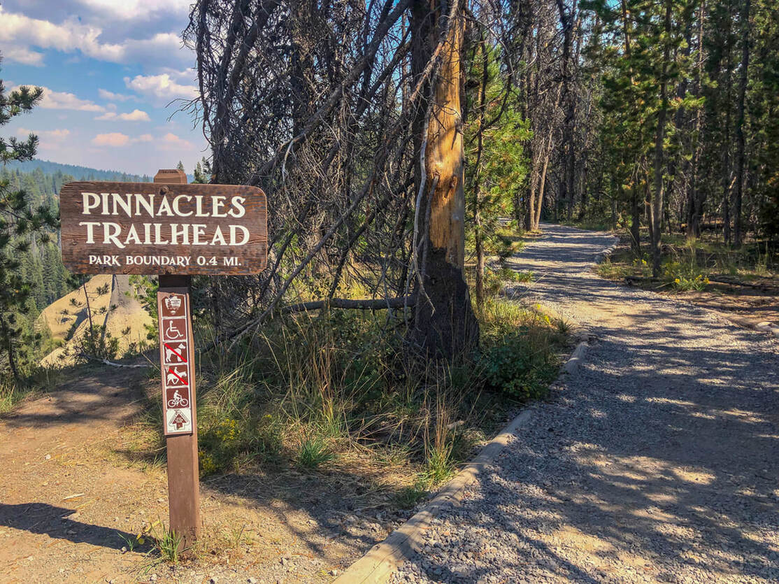
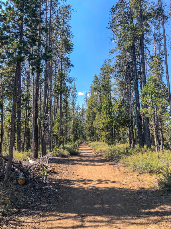
The Pinnacles Trailhead Crater Lake National Park

​Description:

The Pinnacles Trail is a very unique and frequently overlooked, family friendly trail in the heart of Crater Lake National Park. This trail is perfect for those looking for less crowded options inside of the park, with awesome views of very unique rock formations, and lots of history. 
The trailhead is a loop drive with not a lot of parking. This is usually not a problem though because this trail is not one of the incredibly popular sites in the park that people tend to flock to, and this trail is sadly often overlooked. 
The Pinnacles Crater Lake National Park
The Pinnacles Trail Crater Lake National Park
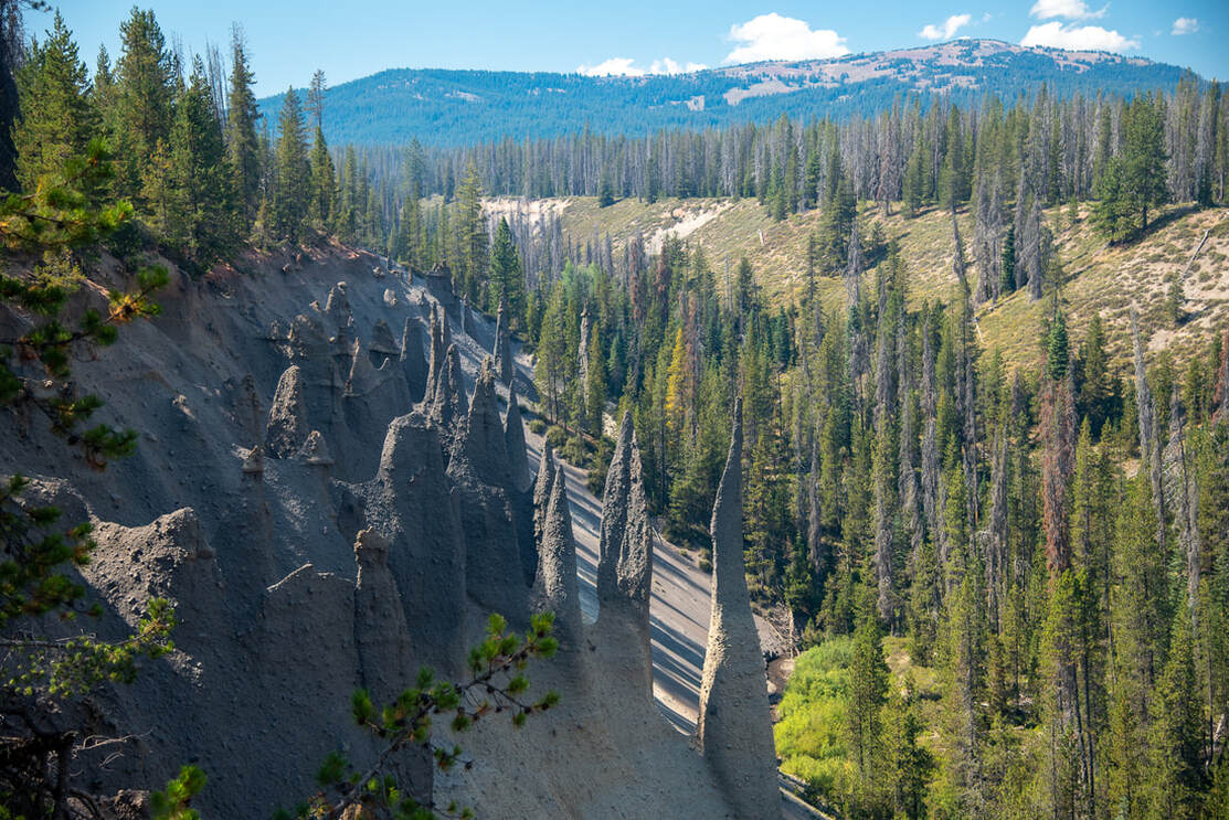
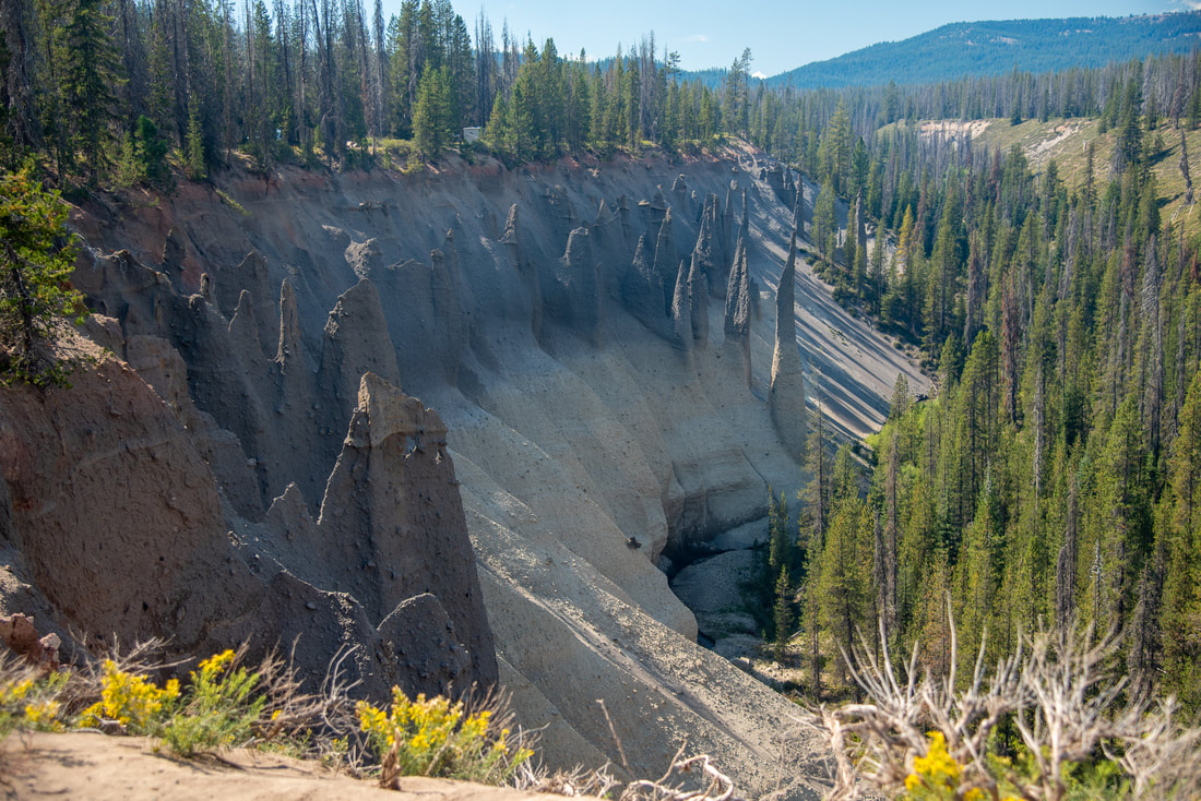
As you walk down the well graded, wide gravel pathway, you will come to many spots where there are viewpoints right off the trail. Most of the viewpoints do not have guard rails of any kind, so if you are with small children, make sure they do not go near the edge. 
At one of the viewpoints you can see down to Wheeler Creek, and later on along the trail you will see the confluence of Wheeler and Sand Creek. 
The Pinnacles viewpoint Crater Lake National Park
(Wheeler Creek)
close up view of the Pinnacles Crater Lake National Park
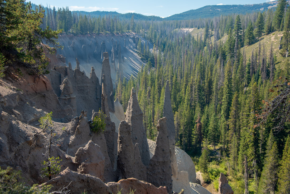
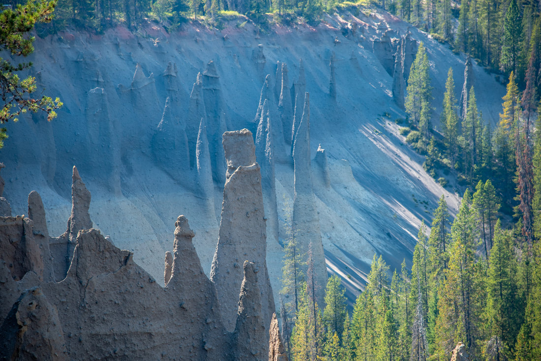
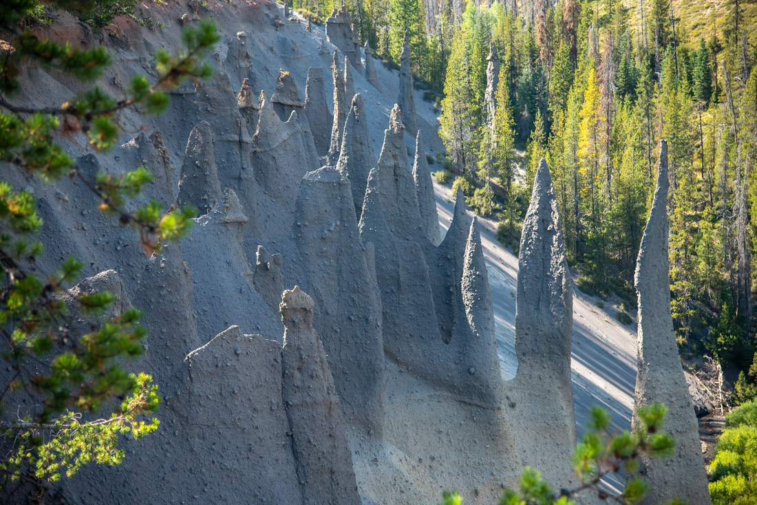
How were the pinnacles formed? During the Ice Age, glaciers made valleys through Godfrey Glen and Annie Creek canyons. When Mount Mazama erupted, the valleys were filled with hot pumice and ash. When the lava stopped moving, gas rose upwards through it, making ash into solid  rock. Over the years, streams have carved narrow canyons into the soft ashen landscape, exposing the old gas vents into spires. 
the sand Pinnacles Crater Lake National Park
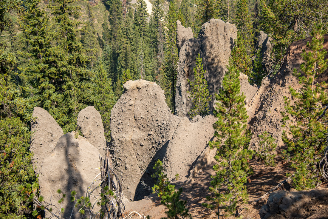
(some of the pinnacles up close)
view of Mount Scott from the Pinnacles Trail Crater Lake National Park
(pinnacles across the creek and Mount Scott in the distance)
Pinnacles Crater Lake National Park
trail to the old east entrance Crater Lake National Park
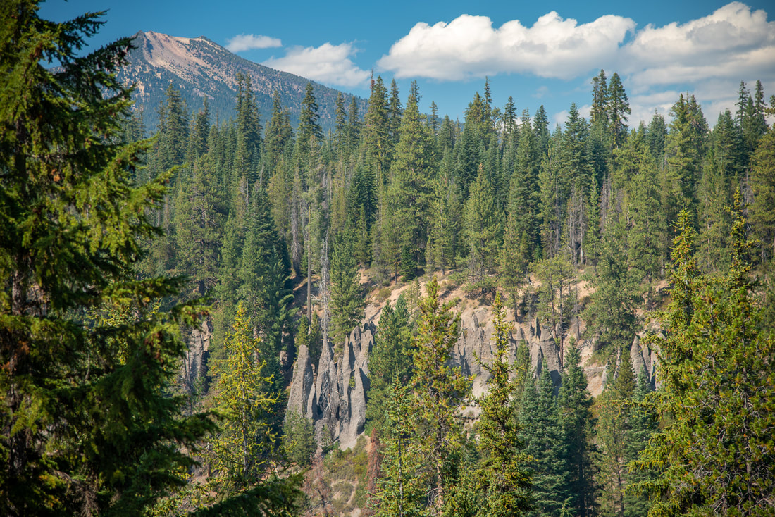
This entire trail is amazing to walk along and you get many different vantage points of the Pinnacles on both sides of the creek. You will also see Mount Scott looming to the northeast. (This is another hike that should not be missed when you're at Crater Lake National Park).
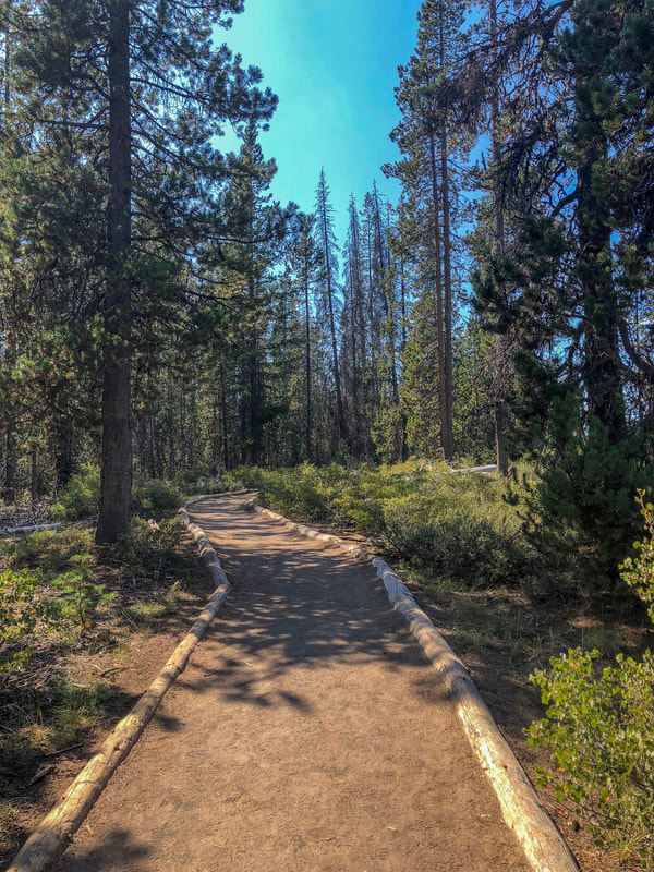
The last little bit of the trail is not gravel, but the path continues to stay very wide as you hike the last few hundred yards through the forest. This section doesn't have any Pinnacle views, however it is very interesting to go to the end of the trail because this is where the old east entrance of the National Park used to be. From 1927 to 1956 this was the east entrance, with the realignment of Highway 97, it closed in 1956. 
informational sign at the old east entrance Crater Lake National Park
Crater Lake old east entrance boundary marker
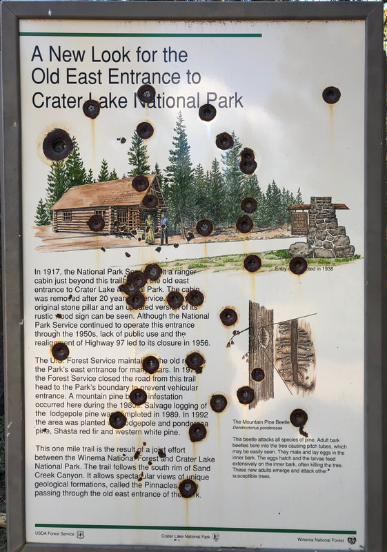
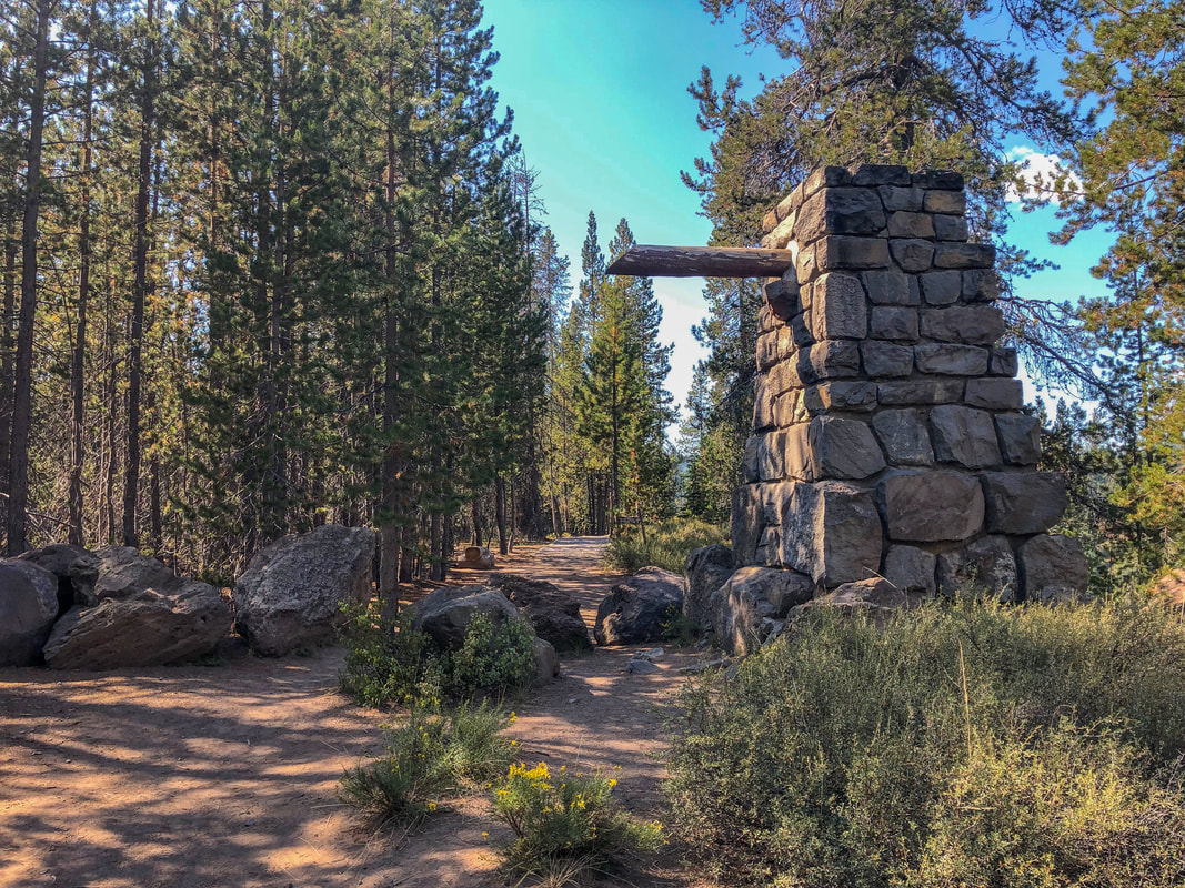
(old east entry sign post)
Overall, the Pinnacles trail should not be missed when visiting Crater Lake National Park. It holds an incredible amount of history of the landscape that one can through these unique rock formations, and also the history of the national park that you can see by walking to the old east entrance and what is now the park boundary. This trail is great for all ages and ability levels and it is even wheelchair and bike friendly. 
Pinnacle rock formations Crater Lake National Park

Directions:

From Medford
  • Drive on OR-62 E for a total of 50 miles, then at a Y junction stay right on OR-62 E for another 15.8 miles. Turn left onto Munson Valley Rd/Volcanic Legacy Scenic Byway and stay on this road for 3.9 miles, then turn right onto Rim Dr/Volcanic Legacy Scenic Byway​ for 8.2 miles. Turn right onto Pinnacles Rd. and drive 6 miles to the trailhead at the road's end. (Total of 90.5 miles)
From Bend
  • ​Drive on US-97 S for 74.5 miles then turn right onto OR-138 W for 14.7 miles. At a sign for Crater Lake National Park turn left onto State Hwy 209/Crater Lake Hwy N/Volcanic Legacy Scenic Byway for 9.2 miles. Turn left onto Rim Dr/Volcanic Legacy Scenic Byway for 14.8 very windy miles, then turn left onto Pinnacles Rd. and drive 6 miles to the trailhead at the road's end. (Total of 120 miles)
From Eugene
  • Drive I-5 S toward Roseburg for 5.3 miles then take exit 188 for OR-58 toward Oakridge/Klamath Falls and stay on this road for 86.6 miles until you merge onto US-97 S. Stay on US-97 S for a total of 17.9 miles, then turn right onto OR-138 W for 14.7 miles. At a sign for Crater Lake National Park turn left onto State Hwy 209/Crater Lake Hwy N/Volcanic Legacy Scenic Byway for 9.2 miles. Turn left onto Rim Dr/Volcanic Legacy Scenic Byway for ​14.8 very windy miles, then turn left onto Pinnacles Rd. and drive 6 miles to the trailhead at the road's end. (Total of 156 miles)
From Salem
  • Total of 218 miles via Eugene.
From Portland
  • Total of 262 miles via Eugene.
*All pictures are taken by Franziska Weinheimer
*Disclaimer: The trail descriptions, mileage, GPS tracks and difficulty ratings depicted on this website are never 100% accurate. Always hike at your own risk, using your own knowledge, equipment and common sense. 
Franziska Weinheimer/Hike Oregon are not responsible if you or anyone in your party gets injured or lost while attempting one of these or any other hikes.

HIKED HERE RECENTLY?! PLEASE LEAVE A TRIP REPORT BELOW:

© Hike Oregon 2022
P.O. Box 41911
​Eugene, OR 97404
Proudly powered by Weebly
  • Home
  • *Store*
  • About the author
  • How to use this site
  • Resources
    • Wildflowers
    • Videos
  • Best Oregon Hikes
    • 20 Epic Oregon Wildflower Hikes
    • Top 10 Oregon Spring Hikes
    • 20 Best Oregon Waterfall Hikes
    • Top 10 Oregon Hikes for Kids
    • 5 Weekend Backpacking Trips in Oregon
    • Top One Night Backpacking Trips in Oregon
    • Top Fall Foliage Hikes In Oregon
    • Top 10 Oregon Summer Hikes
    • Top 10 Swimming Spots In Oregon
    • Top 10 Oregon Fall Hikes
    • Sno-Parks In Central Oregon
    • Top 10 Oregon Winter Hikes
    • Top Low Elevation Winter Hikes
  • Oregon Sno-Parks
    • Maxwell Sno-Park
    • Potato Hill Sno-Park
    • Ray Benson Sno-Park
      • Brandenburg Shelter
    • Santiam Sno-Park
    • Three Creek Sno-Park
    • Virginia Meissner Sno-Park
      • Meissner Shelter Loop
      • Nordeen Shelter
    • Gold Lake Sno-Park
      • Westview Shelter to Eagle Rock Overlook
      • Marilyn Lakes Loop
  • Portland
    • Powell Butte
    • Forest Park
    • Hamilton Mountain
    • Latourell Falls
    • Multnomah/Wahkeena Falls
    • Dog Mountain
    • Coyote Wall
    • Mitchell Point
    • Table Rock
    • Tamanawas Falls
    • Trillium Lake
    • East Zigzag Mountain (members only)
  • Salem
    • Abiqua Falls
    • Silver Falls State Park
    • Marion Lake to Marion Mountain
    • Jefferson Park
  • Sweet Home
    • Crescent Mountain
    • Iron Mountain
    • McDowell Creek Falls
    • Middle Santiam River (members only)
    • Lower Soda Creek Falls (members only)
    • Rooster Rock (members only)
  • McKenzie Bridge/Blue River
    • Macduff Mountain
    • Proxy Falls
    • Clear Lake
    • Sahalie/Koosah Falls
    • Blue Pool
    • Erma Bell Lakes
    • Olallie Mountain
    • Horsepasture Mountain
    • Tidbits Mountain
    • Castle Rock
    • East Fork Trail (members only)
    • Rainbow Falls Overlook (members only)
    • Frissell Point (members only)
    • Chucksney Mountain (members only)
    • Substitute Point (members only)
  • Sisters/Santiam Pass
    • Coffin Mountain
    • Trappers Butte and Scar Mountain
    • Black Butte
    • Tam McArthur Rim
    • Black Crater
    • Scott Mountain
    • Obsidian Trail
    • Three Fingered Jack Loop
    • Square Lake
    • Canyon Creek Meadows
    • Patjens Lakes
    • Craig Lake (members only)
    • Chush Falls (members only)
    • Rockpile Lake (members only)
    • Santiam Lake (members only)
    • Camp Lake (members only)
    • Park Meadow to Golden Lake (members only)
  • Bend/Redmond/LaPine
    • Steins Pillar
    • Chimney Rock
    • Steelhead Falls
    • Tumalo State Park
    • Tumalo Falls
    • Tumalo Mountain
    • No Name Lake
    • Green Lakes
    • Moraine Lake
    • South Sister Summit
    • Muskrat Lake
    • Paulina Peak
    • Peter Skene Ogden Trail (members only)
  • Eugene
    • Ridgeline Trail
    • Mount Pisgah Summit
    • Mount Pisgah Arboretum
    • Shotgun Creek
    • Mount June
    • Lawler
    • Tire Mountain
    • Goodman Creek
    • Brice Creek
    • Trestle Creek Falls
    • Moon Falls
    • Elijah Bristow State Park
    • South Willamette Trail (members only)
    • Eula Ridge (members only)
    • Eagle's Rest (members only)
  • Oakridge
    • Deception Creek
    • North Salmon Creek
    • Grasshopper Ridge
    • Larison Creek
    • Bunchgrass Ridge
    • Salt Creek Falls
    • Waldo Lake Loop
    • South Waldo Loop
    • The Twins
    • Rosary Lakes
    • Fawn Lake
    • Windy Lakes
    • Divide Lake
    • Diamond Peak Summit
    • Cowhorn Mountain
    • Wall Creek Warm Springs (members only)
    • Moon Point (members only)
    • Bobby Lake (members only)
    • Lillian Falls (members only)
    • Middle Fork Willamette Trail (members only)
    • Pool Creek Falls (members only)
    • Dead Mountain (members only)
    • Larison Rock (members only)
    • Eddeeleo Lakes (members only)
    • Waldo Mountain Lookout (members only)
    • Blair Lake to Mule Mountain (members only)
    • Rigdon Lakes loop (members only)
  • Oregon Coast
    • Cascade Head
    • Drift Creek Falls
    • Sweet Creek Falls
    • Alsea Falls
    • Kentucky Falls
    • Marys Peak North Ridge
    • Marys Peak East Ridge
    • Cape Perpetua Loops
    • Hobbit Trail to Heceta Head
    • North Fork Smith River (members only)
    • Cummins Ridge (member's only)
    • Horse Creek (members only)
    • Siltcoos Lake (members only)
    • William Finley Wildlife Refuge (members only)
  • Southern Oregon
    • Fall Creek Falls
    • Watson Falls
    • Wild Rogue Loop
    • Mt. Thielsen
    • The Watchman
    • Mount Scott
    • The Pinnacles
    • Lower Table Rock
    • Pilot Rock
    • Wagner Butte
    • Mt. McLoughlin
    • Lemolo Falls (members only)
    • Fern Falls (members only)
  • Eastern Oregon
    • Painted Cove
    • Mount Howard
    • Anthony Lake Loop
    • Schneider Cabin (members only)
    • Strawberry Lake & Falls (members only)
  • Oregon PCT sections
    • PCT: OR-58 to Charlton Lake
    • PCT: Santiam Pass to Rockpile Lake
  • Tips & Tricks
    • Leave No Trace
    • Top Tips For Hiking With Infants And Toddlers
    • Poison Oak, Ivy and Sumac
    • How to dress for cold weather hikes
    • Hiker Holiday Gift Guide 2019
    • Outdoor Holiday Gift Guide 2018
    • Hiking Holiday Gift Guide 2017
  • Reviews
    • Outdoor Herbivore Backpacking Food Review
    • Osprey Aura AG 65 Backpack review
    • Big Agnes Fly Creek UL2 review
    • REI Quarter Dome 1 review
  • Adventure Stories
    • Hiking The Rae Lakes Loop
    • 110 Miles on the PCT
    • The Loop Around Three Fingered Jack
    • Jefferson Wilderness