Hike Oregon
  • Home
  • *Store*
  • About the author
  • How to use this site
  • Resources
    • Wildflowers
    • Videos
  • Best Oregon Hikes
    • 20 Epic Oregon Wildflower Hikes
    • 5 Weekend Backpacking Trips in Oregon
    • Top 10 Swimming Spots In Oregon
    • 9 Amazing Oregon Summit Hikes
    • Top 10 Oregon Summer Hikes
    • 20 Central Oregon Day Hikes
    • Top One Night Backpacking Trips in Central Oregon
    • Top 10 Oregon Hikes for Kids
    • 20 Best Oregon Waterfall Hikes
    • Underrated Fall Foliage Hikes In Oregon
    • Top 10 Oregon Fall Hikes
    • Best Rainy Day Hikes In Oregon
    • Sno-Parks In Central Oregon
    • Top 10 Oregon Winter Hikes
    • Top Low Elevation Winter Hikes
    • Easy Hikes in Oregon
    • Top 10 Oregon Spring Hikes
  • Oregon Sno-Parks
    • Maxwell Sno-Park
    • Potato Hill Sno-Park
    • Ray Benson Sno-Park
      • Brandenburg Shelter
    • Santiam Sno-Park
    • Three Creek Sno-Park
    • Virginia Meissner Sno-Park
      • Meissner Shelter Loop
      • Nordeen Shelter
    • Gold Lake Sno-Park
      • Westview Shelter to Eagle Rock Overlook
      • Marilyn Lakes Loop
    • Ikenick Sno-Park (members only)
  • Southern Washington
    • Hamilton Mountain
    • Dog Mountain
    • Coyote Wall
    • Mount St. Helens
  • Portland
    • Powell Butte
    • Forest Park
    • Latourell Falls
    • Multnomah/Wahkeena Falls
    • Eagle Creek
    • Mitchell Point
    • Table Rock
    • Tamanawas Falls
    • Trillium Lake
    • East Zigzag Mountain (members only)
  • Salem
    • Abiqua Falls
    • Silver Falls State Park
    • Dome Rock
    • Marion Lake to Marion Mountain
    • Jefferson Park via Whitewater Trail
  • Corvallis
    • William Finley Wildlife Refuge
      • Campbell Boardwalk
      • Woodpecker Loop
      • Mill Hill Loop
      • Beaver Pond Loop
    • Marys Peak East Ridge
    • Marys Peak North Ridge
    • Alsea Falls and Green Peak Falls
    • Corvallis to Sea Trail - Sugarbowl Creek segment (members only)
  • Sweet Home
    • Crescent Mountain
    • Iron Mountain
    • McDowell Creek Falls
    • Middle Santiam River (members only)
    • Lower Soda Creek Falls (members only)
    • Rooster Rock (members only)
  • McKenzie Bridge/Blue River
    • Macduff Mountain
    • Proxy Falls
    • Clear Lake
    • Sahalie/Koosah Falls
    • Blue Pool
    • Erma Bell Lakes
    • Olallie Mountain
    • Horsepasture Mountain
    • Tidbits Mountain
    • Castle Rock
    • Separation Lake (members only)
    • Lowder Mountain (members only)
    • East Fork Trail (members only)
    • Rainbow Falls Overlook (members only)
    • Frissell Point (members only)
    • Substitute Point (members only)
  • Sisters/Santiam Pass
    • Coffin Mountain
    • Trappers Butte and Scar Mountain
    • Maxwell Butte
    • Black Butte
    • Whychus Creek Trail
    • Tam McArthur Rim
    • Black Crater
    • Scott Mountain
    • Obsidian Trail
    • Metolius Preserve
    • Three Fingered Jack Loop
    • Square Lake
    • Canyon Creek Meadows
    • Patjens Lakes
    • Craig Lake (members only)
    • Chush Falls (members only)
    • Rockpile Lake (members only)
    • Santiam Lake (members only)
    • Camp Lake (members only)
    • Park Meadow to Golden Lake (members only)
  • Bend/Redmond/LaPine
    • Steins Pillar
    • Chimney Rock
    • Steelhead Falls
    • Tumalo State Park
    • Shevlin Park Loop
    • Tumalo Falls
    • Tumalo Mountain
    • No Name Lake
    • Green Lakes
    • Moraine Lake
    • South Sister Summit
    • Horse Lake
    • Muskrat Lake
    • Paulina Peak
    • The Badlands - Flatiron Rock Trail
    • Peter Skene Ogden Trail (members only)
  • Eugene
    • Ridgeline Trail
    • Mount Pisgah Summit
    • Mount Pisgah Arboretum
    • Shotgun Creek
    • Mount June
    • Lawler
    • Tire Mountain
    • Hardesty Mountain
    • Goodman Creek
    • Brice Creek
    • Trestle Creek Falls
    • Parker Falls
    • Moon Falls
    • Elijah Bristow State Park
    • South Willamette Trail (members only)
    • Eula Ridge (members only)
    • Eagle's Rest (members only)
  • Oakridge
    • Deception Butte
    • North Salmon Creek
    • Sourgrass Mountain
    • Grasshopper Ridge
    • Larison Creek
    • Bunchgrass Ridge
    • Salt Creek Falls
    • Waldo Lake Loop
    • South Waldo Loop
    • The Twins
    • Rosary Lakes
    • Yoran Lake
    • Fawn Lake
    • Windy Lakes
    • Divide Lake
    • Diamond Peak via Rockpile Lake Trailhead
    • Diamond Peak via Summit Lake
    • Cowhorn Mountain
    • Klovdahl Bay (members only)
    • Verdun Trail (members only)
    • Heckletooth Mountain (members only)
    • Wall Creek Warm Springs (members only)
    • Moon Point (members only)
    • Bobby Lake (members only)
    • Lillian Falls (members only)
    • Middle Fork Willamette Trail (members only)
    • Pool Creek Falls (members only)
    • Dead Mountain (members only)
    • Larison Rock (members only)
    • Quinn Lakes & Eddeeleo Lakes (members only)
    • Waldo Mountain Lookout (members only)
    • Blair Lake to Spring Prairie (members only)
    • Rigdon Lakes loop (members only)
  • Oregon Coast
    • Cascade Head
    • Drift Creek Falls
    • Sweet Creek Falls
    • Beaver Creek Falls
    • Kentucky Falls
    • Hobbit Trail to Heceta Head
    • Valley Trail to China Creek
    • Sutton Creek Trail (members only)
    • North Fork Smith River (members only)
    • Cummins Ridge (member's only)
    • Horse Creek (members only)
    • Siltcoos Lake (members only)
  • Southern Oregon
    • Fall Creek Falls
    • Watson Falls
    • Wild Rogue Loop
    • Mt. Thielsen
    • Crater Lake National Park
      • The Watchman
      • Mount Scott
      • The Pinnacles
    • Lower Table Rock
    • Pilot Rock
    • Wagner Butte
    • Mt. McLoughlin
    • Lemolo Falls (members only)
    • Fern Falls (members only)
  • Eastern Oregon
    • Painted Cove
    • Anthony Lake Loop
    • Mount Howard
    • Eagle Cap summit
    • Schneider Cabin (members only)
    • Strawberry Lake & Strawberry Falls (members only)
  • Northern California
    • Taylor & Hogan Lake (members only)
  • Oregon PCT sections
    • PCT: CA border to Callahan's
  • Tips & Tricks
    • Leave No Trace
    • Safety Tips for Solo Hiking & Backpacking
    • Nutrition On The Trail
    • How Much Water To Carry When Backpacking
    • Storing Your Bear Canister When Backpacking
    • How To Pick The Right Backpacking Tent
    • Top Tips For Hiking With Infants And Toddlers
    • Poison Oak, Ivy and Sumac
    • How to dress for cold weather hikes
  • Reviews and Gear
    • Choosing and Using Trekking Poles
    • A Guide to Choosing the Perfect Backpacking Pack
    • Hiking Pants and Leggings
    • Jackets for Hiking and Backpacking
    • Long Sleeved Shirts For Cold Weather Hiking
    • Stay Kühl This Summer
    • Outdoor Herbivore Backpacking Food Review
    • Osprey Aura AG 65 Backpack review
    • Big Agnes Fly Creek UL2 review
    • REI Quarter Dome 1 review
    • Hike Oregon's Gear Favorites
    • Outdoorsy Holiday Gift Guide 2022
    • Hiker Holiday Gift Guide 2019
    • Outdoor Holiday Gift Guide 2018
    • Hiking Holiday Gift Guide 2017
  • Adventure Stories
    • Hiking The Rae Lakes Loop
    • 110 Miles on the PCT
    • Three Fingered Jack Adventures
    • Jefferson Wilderness

Tam McArthur Rim

​

Broken Hand & No Name Lake

​
Get the printable version of this hike

Hike details:

Mileage: 5.6 miles round trip w/ 1,250 ft. elevation gain (to the end of Tam McArthur Rim Trail)
11.5 miles round trip w/ 2,195 ft. elevation gain (to No Name Lake)

Approximate hike time: 2 hours 26 minutes w/ an average pace of 2.5 mph (to the end of Tam McArthur Rim Trail)
5 hours w/ an average pace of 2.3 mph 
(to No Name Lake)
Difficulty: Moderate to difficult
Trail usage: High during the summer, low on fall weekdays, medium on fall weekends
Highest elevation: 8,353 ft. Lowest elevation: 6,510 ft.
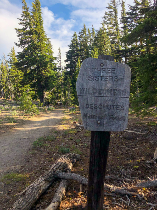
General location: 16 miles south of Sisters - Three Sisters Wilderness - Deschutes National Forest
Accessible: End of June to early November (for just Tam McArthur Rim Trail, it can be dangerous to access No Name Lake until mid to late July due to snow at Broken Hand)
(Best time to go is early August to see some wildflowers. If you want to hike when there are less people, go here in mid to late September or early October).
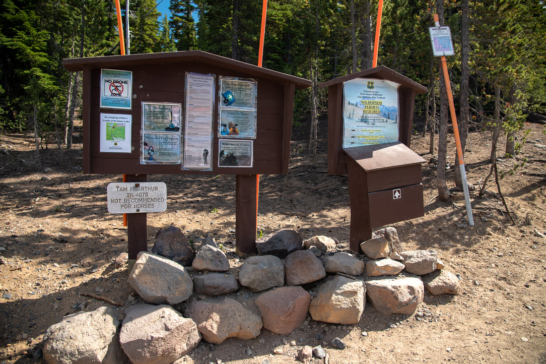
Permits required: Day trips & overnight - Central Cascades Wilderness Permit June 15 - October 15 available via recreation.gov
Pit toilet at trailhead: No
Trail allows: Dogs on leash, camping
Possible dangers: ​Steep drop offs along the rim
Tam McArthur Rim trailhead

Description:

Tam McArthur Rim is one of the most popular hikes in Central Oregon and for good reason. It is moderate in difficulty and offers absolutely spectacular views of the Cascade mountains as well as some of the amazing blue-green alpine lakes nearby. You can choose to keep this hike short and family friendly at 5.6 miles round trip, or you can continue on the trail around Broken Hand and go all the way to Broken Top and No Name Lake, making it a much more difficult hike at 11.5 miles roundtrip and 2,195 feet elevation gain. 
The parking area is large but even so, the trailhead fills up and cars spill out onto the main gravel road during summer weekends even with the limited entry permit system that was put in place in 2020. It is recommended to do this hike on a week day and/or very early in the morning!
Three Sisters Wilderness Tam McArthur Rim Trail
Beginning of Tam McArthur Rim Trail
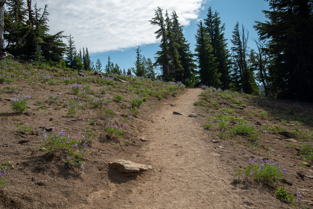
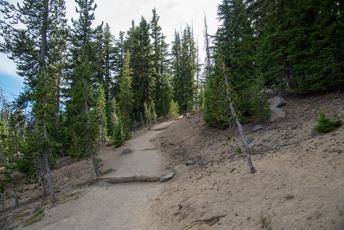
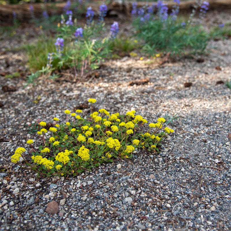
(example of some of the dusty trail tread and wildflowers)
The wide smooth trail starts out steadily climbing uphill the first half mile. In late July and early August the trail is lined with beautiful purple lupine flowers. After 0.5 miles you will start going up some short switchbacks which last for the next 0.3 miles. From here you can enjoy some of your first views of Three Creek Lake below and Mount Washington, Three Fingered Jack and Mount Jefferson to the north. 
Three Creek Lake
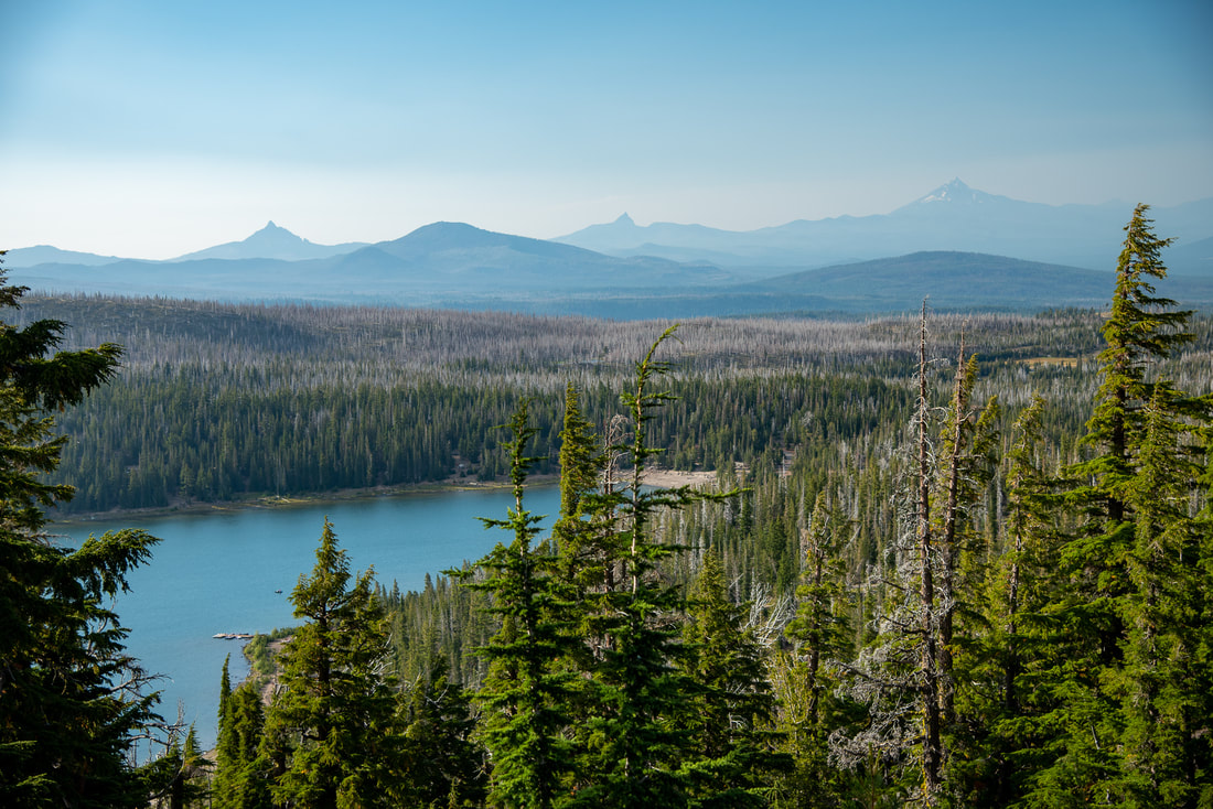
(Three Creek Lake, Mount Washington, Three Fingered Jack & Mount Jefferson)
Tam McArthur Rim Trail
Trail to Tam McArthur Rim
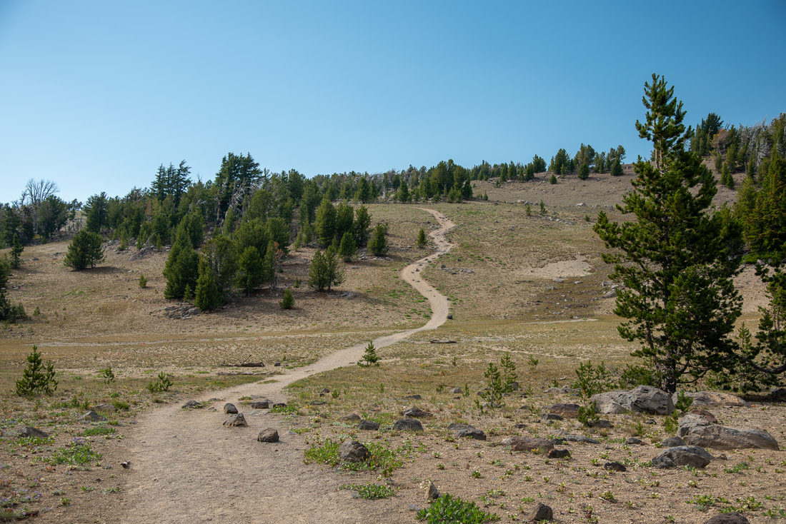
After the switchbacks, the trail wraps around the side of a small hill and then it takes you across a very open meadow area. As you continue going uphill, you will start to see views of Mount Bachelor to the south as well as better views of Three Creek Lake (which is heart shaped if you see it from a certain angle). Once you are on Tam McArthur Rim, you will notice that the trail starts to get a little bit rockier, but the rocks are generally pretty large and they aren't very loose. 
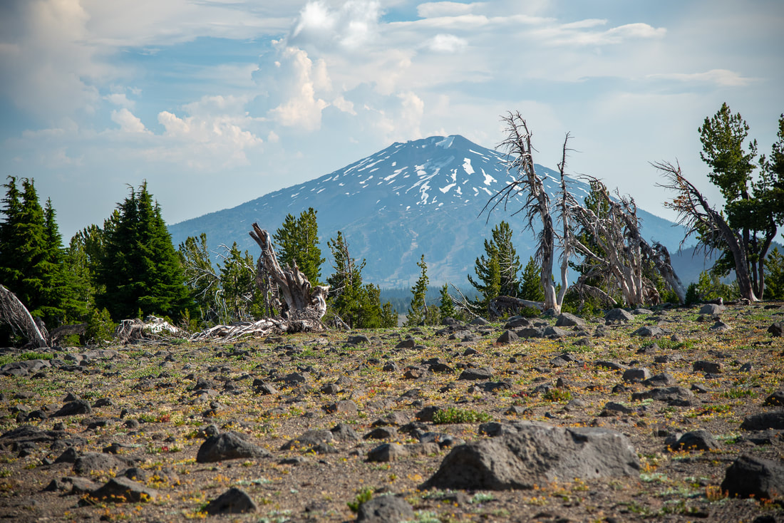
Mt. Bachelor from Tam McArthur Rim Trail
(Mount Bachelor)
Continuation of Tam McArthur Rim Trail
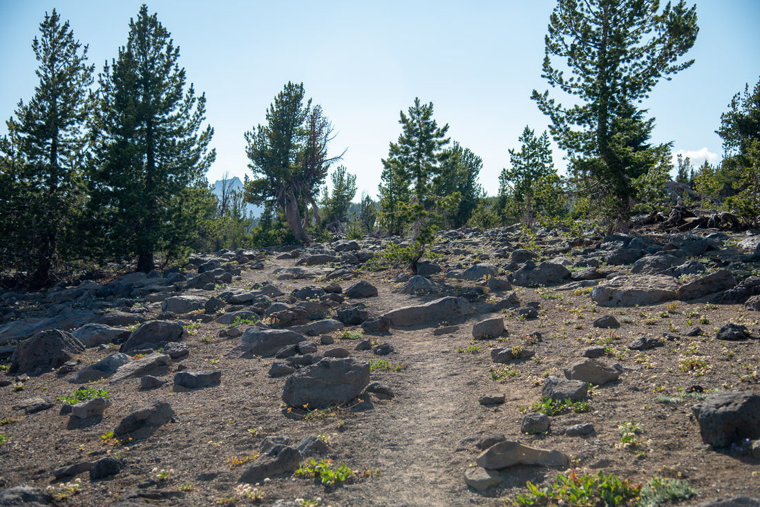
(example of the trail getting rockier)
Little Three Creek Lake
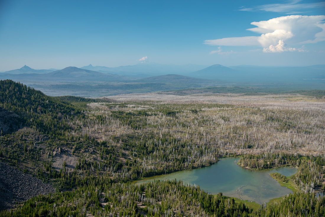
(Upper Three Creek Lake)
End of Tam McArthurn Rim Trail
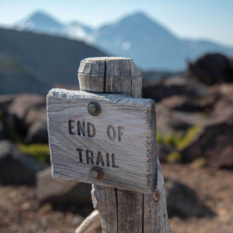
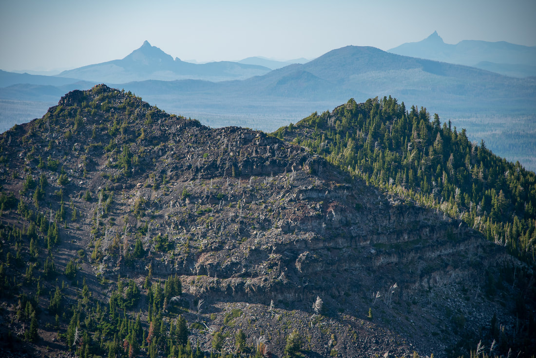
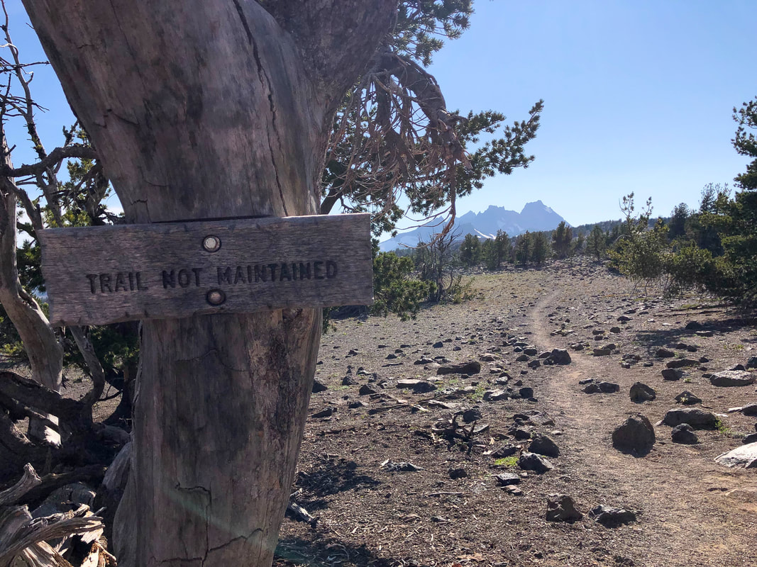
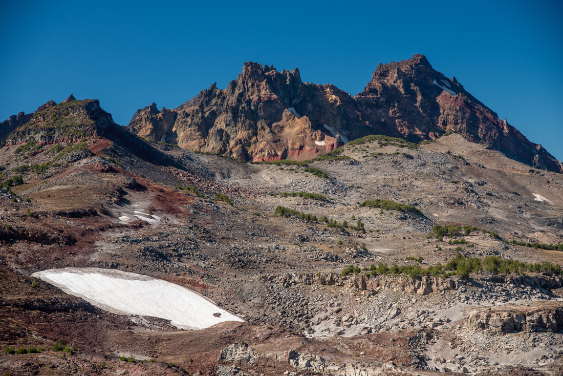
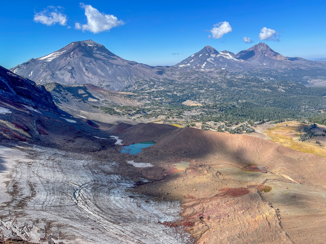
After hiking 0.7 miles along the rim, you will come to an excellent viewpoint where you can see Broken Top and Middle and North Sister up close, as well as the other Cascade mountains to the north. There will be a sign saying End Of Trail and another trail sign nearby that reads Trail Not Maintained. If you can hike long distances and trust your navigation skills through late season snowfields, you can continue heading around Broken Hand and make your way all the way to Broken Top No Name Lake, but that makes this hike a lot longer and because there is no trail maintenance beyond that point, it can be a lot more difficult too. ​Because Tam McArthur Rim is at 7,700 feet elevation, there can be lingering snowdrifts along this trail until mid-July sometimes so if you are not comfortable hiking over some snow, wait until a bit later in the season to do this hike. 
If you have gotten an overnight permit, you can camp on a durable surface away from the trail. Keep in mind, there are no water sources up here, so you will have to carry up all the water you will need for your overnight trip. 
If you are not continuing on to No Name Lake and ending at this viewpoint, you will hike back down the way you came. 
Broken Top from Tam McArthur Rim
(Broken Top)
Middle and North Sister from Tam McArthur Rim
(Middle Sister & North Sister)
Mt. Washington and Three Fingered Jack from Tam McArthur Rim
(Mount Washington and Three Fingered Jack)
Three Creek Lake heart shape lake from Tam McArthur Rim
(Three Creek Lake)
This hike to Tam McArthur Rim is fairly family friendly and is appropriate for most levels of hikers. The only reason it is rated as 'moderate' is because of the elevation gain throughout the hike and there is a very small section of trail is loose and rocky. If you would like to make this hike more difficult, you can continue on over Broken Hand to Broken Top and No Name Lake, otherwise, you can enjoy the scenery at the Tam McArthur Rim viewpoint and then turn back.
Some things to note about this hike:
-The trail is pretty exposed to sun and wind, so remember to pack lots of water, sunscreen as well as a sun hat and an extra layer to throw on. 
-Snow can linger until early July.
​-The trailhead gets crowded, so go early!
-There are steep drop offs along the rim, so be careful if hiking with dogs and kids.
Tam McArthur Rim Trail not maintained
Wildflowers along Tam McArthur Rim trail
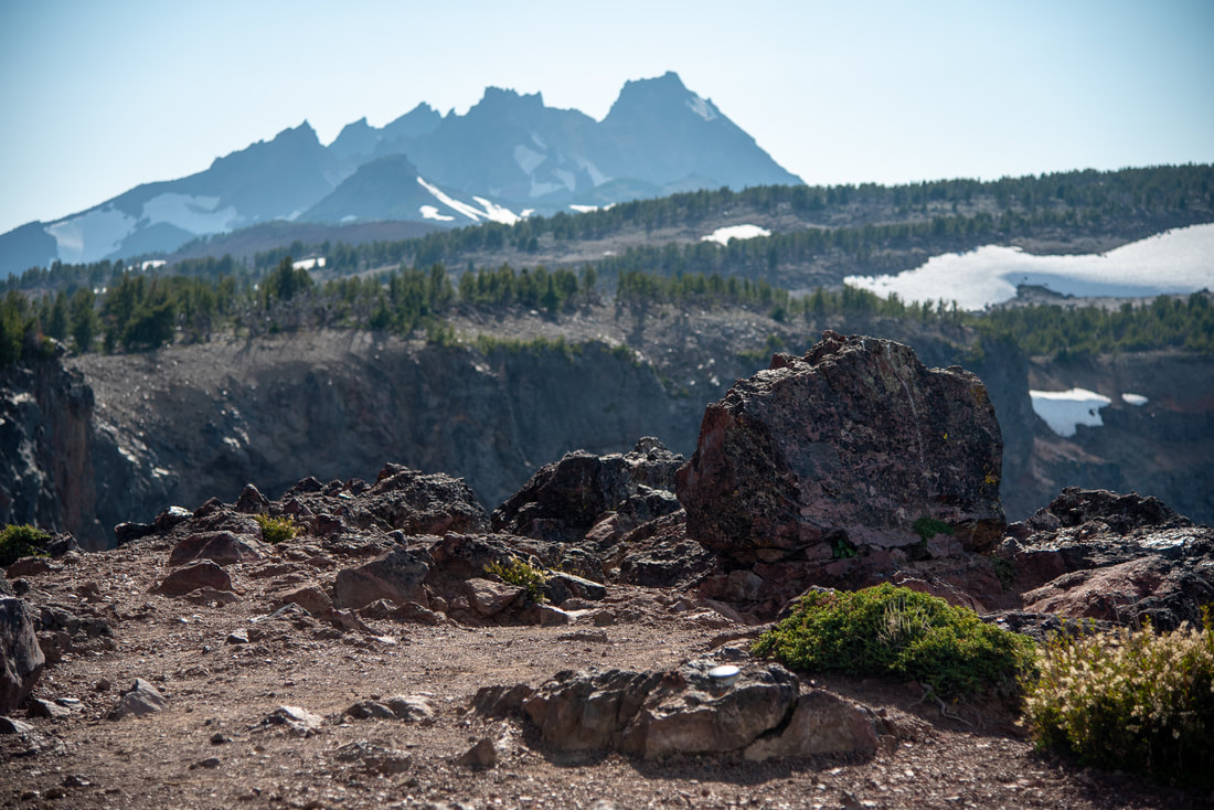
If you are wanting to go to Broken Top/No Name Lake, you will continue on the user trail past this Trail Not Maintained sign. You will hike for about a mile on a fairly easy straight forward trail on a plateau. Even in the fall you will see some snow fields that linger here (see pictures). You will come to an awesome viewpoint and from there the trail starts to gain a little bit more elevation as you approach Broken Hand. 
Tam McArthur Trail to No Name Lake
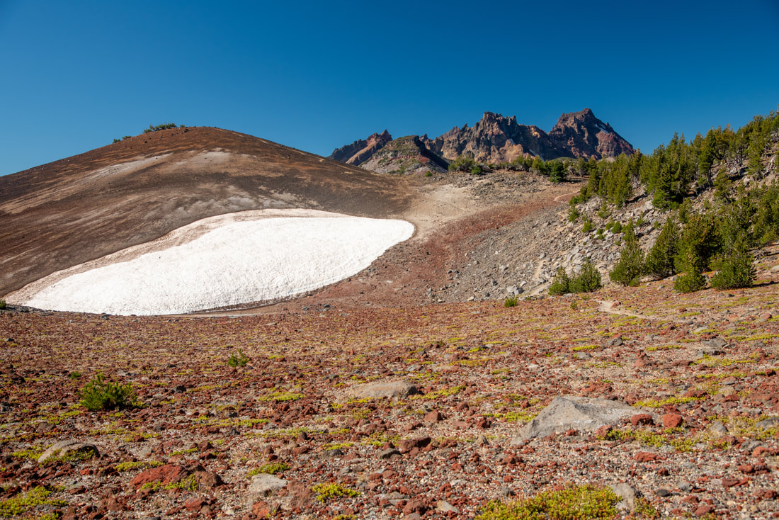
(snow lingering in October)
Broken Top from Tam McArthur Rim Trail
After 0.75 from the viewpoint hiking along a ridgeline, you will see Broken Hand and the trail deviates here a bit. There is a lower trail that people take when snow lingers on the north/shady side of Broken Hand. The trail by Broken Hand has extremely steep drop offs, so if any snow is lingering it can be pretty dangerous, so keep this in mind. You will see if there is snow from a distance away, that way you can make the decision on which route to take early on. The lower trail can be somewhat difficult to follow since it goes through a large boulder field, so if you are going this way, take your time to pick the best route through the rocks. 
Broken Hand
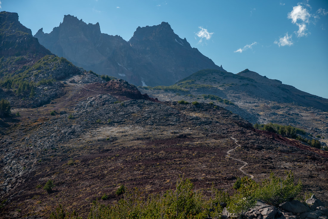
(the trail up to Broken Hand)
Broken Top and No Name Lake from Broken Hand
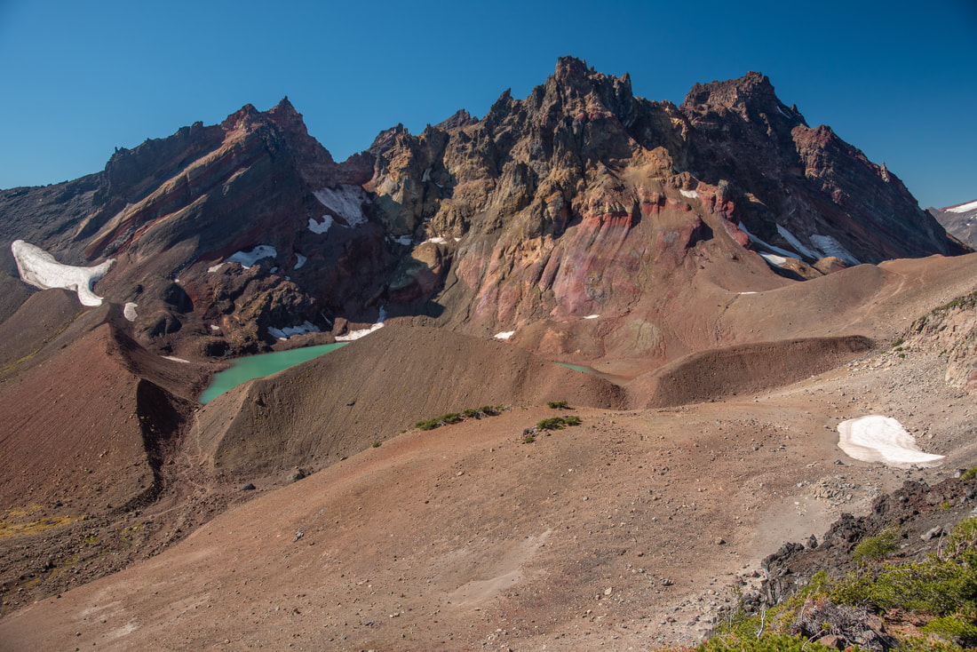
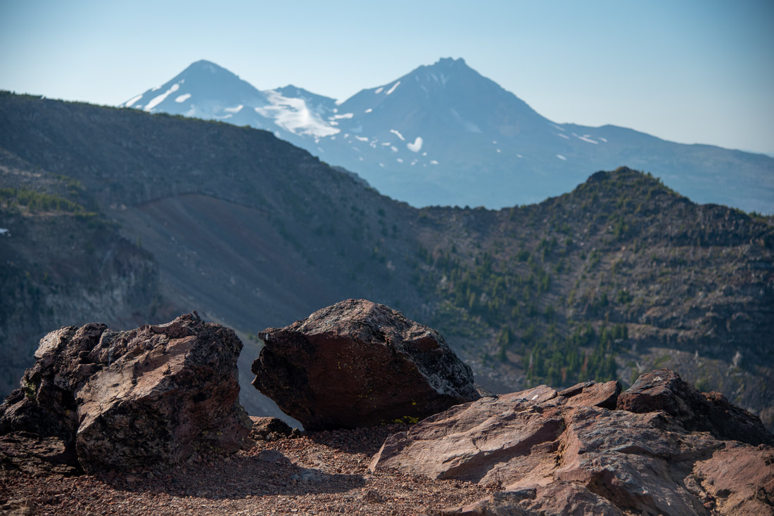
After navigating your way past Broken Hand, you will start seeing views of turquoise colored No Name Lake and Broken Top. It's about half a mile from here to the rim/ridge of Broken Top and No Name Lake. Before making your way down to the lake, make sure to enjoy the view. This is by far one of the best views in Oregon where you can see the Three Sisters, Mount Washington, Three Fingered Jack, Mount Jefferson and Mount Hood. Below you will see Park Meadow and the various tarns above the meadow. 
Three Sisters from Broken Top
(the Three Sisters from the ridgeline viewpoint in October)
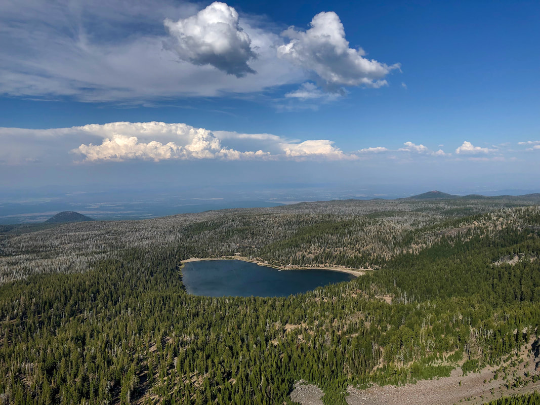
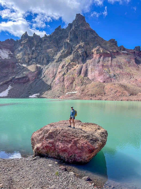
There is a steep 0.3 mile trail from the ridgeline viewpoint down to turquoise colored No Name Lake. A large rock at the edge of the lake is a really great place to get pictures, and if you're brave you can even go for a summer swim in this glacial alpine lake. No Name Lake lies at 8,015 feet and it is definitely one of the most popular hiking destinations in the Oregon Cascades!
No Name Lake from rim
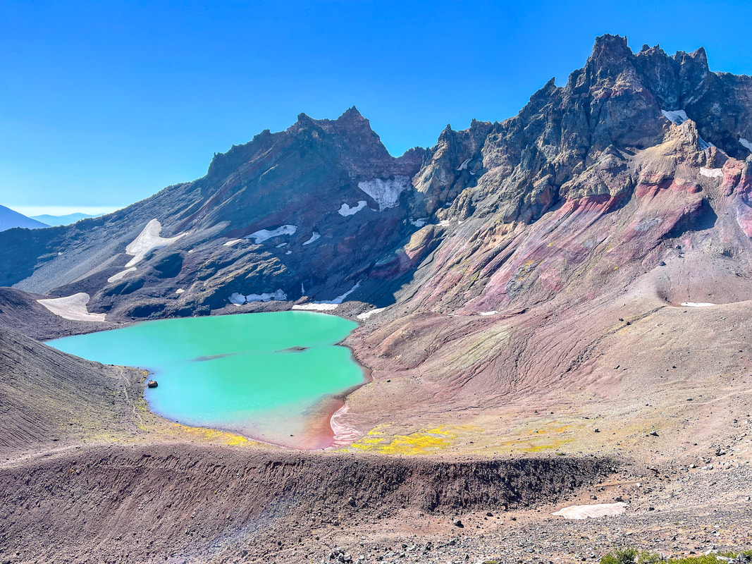
(No Name Lake from the ridgeline viewpoint in October)
Tam McArthur Rim is one of the most scenic hikes in Oregon. Whether you do the short hike up to the first viewpoint and the end of Tam McArthur Rim Trail, or you go up around Broken Hand to No Name Lake, you will enjoy epic views. Because of the elevation of this trail, it is best to do it in late August through September when most of the snow has melted and the route across Broken Hand is less dangerous. If you want to see No Name Lake but this route is too long or sketchy, you can always opt to get a permit starting from the No Name Lake or Crater Ditch trailheads. Keep in mind that this trail is very rocky, so wear good shoes and trekking poles really help with the ascent and descent as well. 
picture rock at No Name Lake

Directions:

From Bend
  • Drive on US-97 north for 2.1 miles then take exit 135A to merge onto US-20 W toward Sisters. Stay on US-20 W for 18.9 miles then turn left onto S Locust St. for 0.2 miles, then turn right onto E Tyee Dr. for 0.4 miles. Turn left onto Three Creek Rd. for 0.9 miles, then turn left onto Three Creek Rd. and stay on this road for about 15 miles and find the trailhead parking on your right. (Total of 38.2 miles)
From Eugene
  • Drive OR-126 east toward Springfield. At a traffic light use the two left lanes to turn left, following signs to continue on OR-126 for another 72.6 miles. Shortly after Clear Lake Resort, take a slight right onto US-20 east for 29 miles to the town of Sisters. In Sisters turn right onto S Elm St. This will become Three Creek Rd/NF-16 after about a mile. Then continue down this road for about 14.5 miles and find the trailhead parking on your right. (Total of  122 miles)
From Salem
  • Drive OR-22 east toward Detroit Lake/Bend for 80.3 miles then take a slight left onto US-20 east to the town of Sisters for 25.5 miles. In Sisters turn right on S Elm St. This will become Three Creek Rd/NF-16 after about a mile. Then continue down this road for about 14.5 miles and find the trailhead parking on your right. (Total of 125 miles)
From Portland
  • Total of 168 miles via Salem.
From Medford
  • Total of 210 miles via Bend.
-This trail write-up was last updated October 2023-
*All pictures are taken by Franziska Weinheimer
*Disclaimer: The trail descriptions, mileage, GPS tracks and difficulty ratings depicted on this website are never 100% accurate. Always hike at your own risk, using your own knowledge, equipment and common sense. Franziska Weinheimer/Hike Oregon are not responsible if you or anyone in your party gets injured or lost while attempting one of these or any other hikes.

HIKED HERE RECENTLY? PLEASE LEAVE A TRIP REPORT BELOW:

© Hike Oregon 2025
P.O. Box 41911
​Eugene, OR 97404
Proudly powered by Weebly
  • Home
  • *Store*
  • About the author
  • How to use this site
  • Resources
    • Wildflowers
    • Videos
  • Best Oregon Hikes
    • 20 Epic Oregon Wildflower Hikes
    • 5 Weekend Backpacking Trips in Oregon
    • Top 10 Swimming Spots In Oregon
    • 9 Amazing Oregon Summit Hikes
    • Top 10 Oregon Summer Hikes
    • 20 Central Oregon Day Hikes
    • Top One Night Backpacking Trips in Central Oregon
    • Top 10 Oregon Hikes for Kids
    • 20 Best Oregon Waterfall Hikes
    • Underrated Fall Foliage Hikes In Oregon
    • Top 10 Oregon Fall Hikes
    • Best Rainy Day Hikes In Oregon
    • Sno-Parks In Central Oregon
    • Top 10 Oregon Winter Hikes
    • Top Low Elevation Winter Hikes
    • Easy Hikes in Oregon
    • Top 10 Oregon Spring Hikes
  • Oregon Sno-Parks
    • Maxwell Sno-Park
    • Potato Hill Sno-Park
    • Ray Benson Sno-Park
      • Brandenburg Shelter
    • Santiam Sno-Park
    • Three Creek Sno-Park
    • Virginia Meissner Sno-Park
      • Meissner Shelter Loop
      • Nordeen Shelter
    • Gold Lake Sno-Park
      • Westview Shelter to Eagle Rock Overlook
      • Marilyn Lakes Loop
    • Ikenick Sno-Park (members only)
  • Southern Washington
    • Hamilton Mountain
    • Dog Mountain
    • Coyote Wall
    • Mount St. Helens
  • Portland
    • Powell Butte
    • Forest Park
    • Latourell Falls
    • Multnomah/Wahkeena Falls
    • Eagle Creek
    • Mitchell Point
    • Table Rock
    • Tamanawas Falls
    • Trillium Lake
    • East Zigzag Mountain (members only)
  • Salem
    • Abiqua Falls
    • Silver Falls State Park
    • Dome Rock
    • Marion Lake to Marion Mountain
    • Jefferson Park via Whitewater Trail
  • Corvallis
    • William Finley Wildlife Refuge
      • Campbell Boardwalk
      • Woodpecker Loop
      • Mill Hill Loop
      • Beaver Pond Loop
    • Marys Peak East Ridge
    • Marys Peak North Ridge
    • Alsea Falls and Green Peak Falls
    • Corvallis to Sea Trail - Sugarbowl Creek segment (members only)
  • Sweet Home
    • Crescent Mountain
    • Iron Mountain
    • McDowell Creek Falls
    • Middle Santiam River (members only)
    • Lower Soda Creek Falls (members only)
    • Rooster Rock (members only)
  • McKenzie Bridge/Blue River
    • Macduff Mountain
    • Proxy Falls
    • Clear Lake
    • Sahalie/Koosah Falls
    • Blue Pool
    • Erma Bell Lakes
    • Olallie Mountain
    • Horsepasture Mountain
    • Tidbits Mountain
    • Castle Rock
    • Separation Lake (members only)
    • Lowder Mountain (members only)
    • East Fork Trail (members only)
    • Rainbow Falls Overlook (members only)
    • Frissell Point (members only)
    • Substitute Point (members only)
  • Sisters/Santiam Pass
    • Coffin Mountain
    • Trappers Butte and Scar Mountain
    • Maxwell Butte
    • Black Butte
    • Whychus Creek Trail
    • Tam McArthur Rim
    • Black Crater
    • Scott Mountain
    • Obsidian Trail
    • Metolius Preserve
    • Three Fingered Jack Loop
    • Square Lake
    • Canyon Creek Meadows
    • Patjens Lakes
    • Craig Lake (members only)
    • Chush Falls (members only)
    • Rockpile Lake (members only)
    • Santiam Lake (members only)
    • Camp Lake (members only)
    • Park Meadow to Golden Lake (members only)
  • Bend/Redmond/LaPine
    • Steins Pillar
    • Chimney Rock
    • Steelhead Falls
    • Tumalo State Park
    • Shevlin Park Loop
    • Tumalo Falls
    • Tumalo Mountain
    • No Name Lake
    • Green Lakes
    • Moraine Lake
    • South Sister Summit
    • Horse Lake
    • Muskrat Lake
    • Paulina Peak
    • The Badlands - Flatiron Rock Trail
    • Peter Skene Ogden Trail (members only)
  • Eugene
    • Ridgeline Trail
    • Mount Pisgah Summit
    • Mount Pisgah Arboretum
    • Shotgun Creek
    • Mount June
    • Lawler
    • Tire Mountain
    • Hardesty Mountain
    • Goodman Creek
    • Brice Creek
    • Trestle Creek Falls
    • Parker Falls
    • Moon Falls
    • Elijah Bristow State Park
    • South Willamette Trail (members only)
    • Eula Ridge (members only)
    • Eagle's Rest (members only)
  • Oakridge
    • Deception Butte
    • North Salmon Creek
    • Sourgrass Mountain
    • Grasshopper Ridge
    • Larison Creek
    • Bunchgrass Ridge
    • Salt Creek Falls
    • Waldo Lake Loop
    • South Waldo Loop
    • The Twins
    • Rosary Lakes
    • Yoran Lake
    • Fawn Lake
    • Windy Lakes
    • Divide Lake
    • Diamond Peak via Rockpile Lake Trailhead
    • Diamond Peak via Summit Lake
    • Cowhorn Mountain
    • Klovdahl Bay (members only)
    • Verdun Trail (members only)
    • Heckletooth Mountain (members only)
    • Wall Creek Warm Springs (members only)
    • Moon Point (members only)
    • Bobby Lake (members only)
    • Lillian Falls (members only)
    • Middle Fork Willamette Trail (members only)
    • Pool Creek Falls (members only)
    • Dead Mountain (members only)
    • Larison Rock (members only)
    • Quinn Lakes & Eddeeleo Lakes (members only)
    • Waldo Mountain Lookout (members only)
    • Blair Lake to Spring Prairie (members only)
    • Rigdon Lakes loop (members only)
  • Oregon Coast
    • Cascade Head
    • Drift Creek Falls
    • Sweet Creek Falls
    • Beaver Creek Falls
    • Kentucky Falls
    • Hobbit Trail to Heceta Head
    • Valley Trail to China Creek
    • Sutton Creek Trail (members only)
    • North Fork Smith River (members only)
    • Cummins Ridge (member's only)
    • Horse Creek (members only)
    • Siltcoos Lake (members only)
  • Southern Oregon
    • Fall Creek Falls
    • Watson Falls
    • Wild Rogue Loop
    • Mt. Thielsen
    • Crater Lake National Park
      • The Watchman
      • Mount Scott
      • The Pinnacles
    • Lower Table Rock
    • Pilot Rock
    • Wagner Butte
    • Mt. McLoughlin
    • Lemolo Falls (members only)
    • Fern Falls (members only)
  • Eastern Oregon
    • Painted Cove
    • Anthony Lake Loop
    • Mount Howard
    • Eagle Cap summit
    • Schneider Cabin (members only)
    • Strawberry Lake & Strawberry Falls (members only)
  • Northern California
    • Taylor & Hogan Lake (members only)
  • Oregon PCT sections
    • PCT: CA border to Callahan's
  • Tips & Tricks
    • Leave No Trace
    • Safety Tips for Solo Hiking & Backpacking
    • Nutrition On The Trail
    • How Much Water To Carry When Backpacking
    • Storing Your Bear Canister When Backpacking
    • How To Pick The Right Backpacking Tent
    • Top Tips For Hiking With Infants And Toddlers
    • Poison Oak, Ivy and Sumac
    • How to dress for cold weather hikes
  • Reviews and Gear
    • Choosing and Using Trekking Poles
    • A Guide to Choosing the Perfect Backpacking Pack
    • Hiking Pants and Leggings
    • Jackets for Hiking and Backpacking
    • Long Sleeved Shirts For Cold Weather Hiking
    • Stay Kühl This Summer
    • Outdoor Herbivore Backpacking Food Review
    • Osprey Aura AG 65 Backpack review
    • Big Agnes Fly Creek UL2 review
    • REI Quarter Dome 1 review
    • Hike Oregon's Gear Favorites
    • Outdoorsy Holiday Gift Guide 2022
    • Hiker Holiday Gift Guide 2019
    • Outdoor Holiday Gift Guide 2018
    • Hiking Holiday Gift Guide 2017
  • Adventure Stories
    • Hiking The Rae Lakes Loop
    • 110 Miles on the PCT
    • Three Fingered Jack Adventures
    • Jefferson Wilderness