Hike Oregon
  • Home
  • *Store*
  • About the author
  • How to use this site
  • Resources
    • Wildflowers
    • Videos
  • Best Oregon Hikes
    • 20 Epic Oregon Wildflower Hikes
    • Top 10 Oregon Spring Hikes
    • 20 Best Oregon Waterfall Hikes
    • Top 10 Oregon Hikes for Kids
    • 5 Weekend Backpacking Trips in Oregon
    • Top One Night Backpacking Trips in Oregon
    • Top Fall Foliage Hikes In Oregon
    • Top 10 Oregon Summer Hikes
    • Top 10 Swimming Spots In Oregon
    • Top 10 Oregon Fall Hikes
    • Sno-Parks In Central Oregon
    • Top 10 Oregon Winter Hikes
    • Top Low Elevation Winter Hikes
  • Oregon Sno-Parks
    • Maxwell Sno-Park
    • Potato Hill Sno-Park
    • Ray Benson Sno-Park
      • Brandenburg Shelter
    • Santiam Sno-Park
    • Three Creek Sno-Park
    • Virginia Meissner Sno-Park
      • Meissner Shelter Loop
      • Nordeen Shelter
    • Gold Lake Sno-Park
      • Westview Shelter to Eagle Rock Overlook
      • Marilyn Lakes Loop
  • Portland
    • Powell Butte
    • Forest Park
    • Hamilton Mountain
    • Latourell Falls
    • Multnomah/Wahkeena Falls
    • Dog Mountain
    • Coyote Wall
    • Mitchell Point
    • Table Rock
    • Tamanawas Falls
    • Trillium Lake
    • East Zigzag Mountain (members only)
  • Salem
    • Abiqua Falls
    • Silver Falls State Park
    • Marion Lake to Marion Mountain
    • Jefferson Park
  • Sweet Home
    • Crescent Mountain
    • Iron Mountain
    • McDowell Creek Falls
    • Middle Santiam River (members only)
    • Lower Soda Creek Falls (members only)
    • Rooster Rock (members only)
  • McKenzie Bridge/Blue River
    • Macduff Mountain
    • Proxy Falls
    • Clear Lake
    • Sahalie/Koosah Falls
    • Blue Pool
    • Erma Bell Lakes
    • Olallie Mountain
    • Horsepasture Mountain
    • Tidbits Mountain
    • Castle Rock
    • East Fork Trail (members only)
    • Rainbow Falls Overlook (members only)
    • Frissell Point (members only)
    • Chucksney Mountain (members only)
    • Substitute Point (members only)
  • Sisters/Santiam Pass
    • Coffin Mountain
    • Trappers Butte and Scar Mountain
    • Black Butte
    • Tam McArthur Rim
    • Black Crater
    • Scott Mountain
    • Obsidian Trail
    • Three Fingered Jack Loop
    • Square Lake
    • Canyon Creek Meadows
    • Patjens Lakes
    • Craig Lake (members only)
    • Chush Falls (members only)
    • Rockpile Lake (members only)
    • Santiam Lake (members only)
    • Camp Lake (members only)
    • Park Meadow to Golden Lake (members only)
  • Bend/Redmond/LaPine
    • Steins Pillar
    • Chimney Rock
    • Steelhead Falls
    • Tumalo State Park
    • Tumalo Falls
    • Tumalo Mountain
    • No Name Lake
    • Green Lakes
    • Moraine Lake
    • South Sister Summit
    • Muskrat Lake
    • Paulina Peak
    • Peter Skene Ogden Trail (members only)
  • Eugene
    • Ridgeline Trail
    • Mount Pisgah Summit
    • Mount Pisgah Arboretum
    • Shotgun Creek
    • Mount June
    • Lawler
    • Tire Mountain
    • Goodman Creek
    • Brice Creek
    • Trestle Creek Falls
    • Moon Falls
    • Elijah Bristow State Park
    • South Willamette Trail (members only)
    • Eula Ridge (members only)
    • Eagle's Rest (members only)
  • Oakridge
    • Deception Creek
    • North Salmon Creek
    • Grasshopper Ridge
    • Larison Creek
    • Bunchgrass Ridge
    • Salt Creek Falls
    • Waldo Lake Loop
    • South Waldo Loop
    • The Twins
    • Rosary Lakes
    • Fawn Lake
    • Windy Lakes
    • Divide Lake
    • Diamond Peak Summit
    • Cowhorn Mountain
    • Wall Creek Warm Springs (members only)
    • Moon Point (members only)
    • Bobby Lake (members only)
    • Lillian Falls (members only)
    • Middle Fork Willamette Trail (members only)
    • Pool Creek Falls (members only)
    • Dead Mountain (members only)
    • Larison Rock (members only)
    • Eddeeleo Lakes (members only)
    • Waldo Mountain Lookout (members only)
    • Blair Lake to Mule Mountain (members only)
    • Rigdon Lakes loop (members only)
  • Oregon Coast
    • Cascade Head
    • Drift Creek Falls
    • Sweet Creek Falls
    • Alsea Falls
    • Kentucky Falls
    • Marys Peak North Ridge
    • Marys Peak East Ridge
    • Cape Perpetua Loops
    • Hobbit Trail to Heceta Head
    • North Fork Smith River (members only)
    • Cummins Ridge (member's only)
    • Horse Creek (members only)
    • Siltcoos Lake (members only)
    • William Finley Wildlife Refuge (members only)
  • Southern Oregon
    • Fall Creek Falls
    • Watson Falls
    • Wild Rogue Loop
    • Mt. Thielsen
    • The Watchman
    • Mount Scott
    • The Pinnacles
    • Lower Table Rock
    • Pilot Rock
    • Wagner Butte
    • Mt. McLoughlin
    • Lemolo Falls (members only)
    • Fern Falls (members only)
  • Eastern Oregon
    • Painted Cove
    • Mount Howard
    • Anthony Lake Loop
    • Schneider Cabin (members only)
    • Strawberry Lake & Falls (members only)
  • Oregon PCT sections
    • PCT: OR-58 to Charlton Lake
    • PCT: Santiam Pass to Rockpile Lake
  • Tips & Tricks
    • Leave No Trace
    • Top Tips For Hiking With Infants And Toddlers
    • Poison Oak, Ivy and Sumac
    • How to dress for cold weather hikes
    • Hiker Holiday Gift Guide 2019
    • Outdoor Holiday Gift Guide 2018
    • Hiking Holiday Gift Guide 2017
  • Reviews
    • Outdoor Herbivore Backpacking Food Review
    • Osprey Aura AG 65 Backpack review
    • Big Agnes Fly Creek UL2 review
    • REI Quarter Dome 1 review
  • Adventure Stories
    • Hiking The Rae Lakes Loop
    • 110 Miles on the PCT
    • The Loop Around Three Fingered Jack
    • Jefferson Wilderness

Larison Creek

​
Get the printable version of this hike

Hike details​:

​Mileage: 10 miles round trip w/ 1,650 ft. elevation gain
Approximate hike time: 4 hours 20 minutes w/ an average pace of 2.3 mph 
Difficulty: Moderate
Trail usage: Low 
Highest elevation: 2,200 ft. Lowest elevation: 1,550 ft.
General location: 5 miles south of Oakridge - Willamette National Forest
Accessible: Year-round
(Best time to go is April and May for lush greenery and the end of September through October for fall colors).
Permits required: N/A
Pit toilet at trailhead: No
Trail allows: Dogs, mountain biking, camping
Possible dangers: N/A
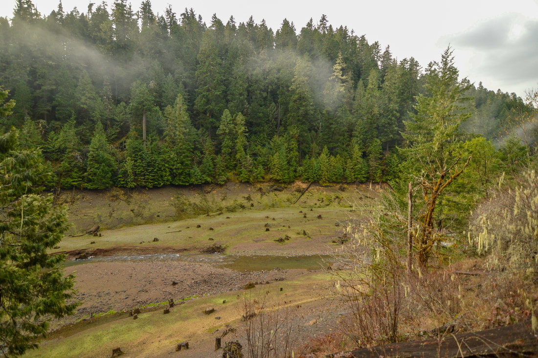
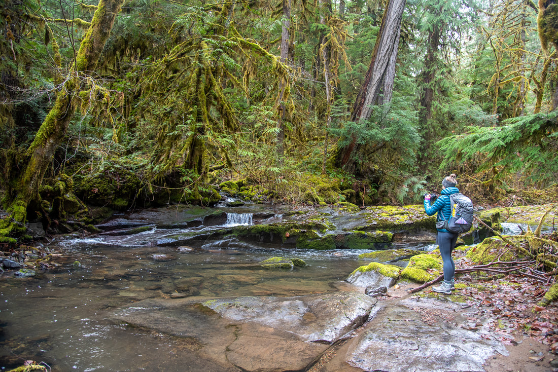
Larison Creek Trail sign

Description​:

Larison Creek Trail #3646 is a wonderful and underrated hike close to Oakridge. This hike is great to do in all seasons, however early spring and fall time are the best. The trail starts out to the right of the parking area (there is room for about 6 cars to park) and it meanders along the edge of Larison Cove. Here you are exposed to the sun early in the day, so on late spring and summer days these few miles will be very warm. Also watch out for poison oak in this spot. Larison Cove is fairly narrow and you can easily see to the other side, which has thick lush old growth forest. It actually looks kind of spooky, and if you yell across the water, your echo comes back to you as clear as day.
Larison Cove
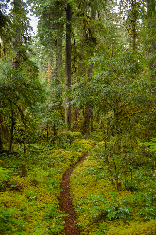
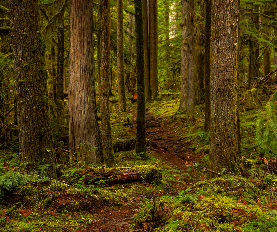
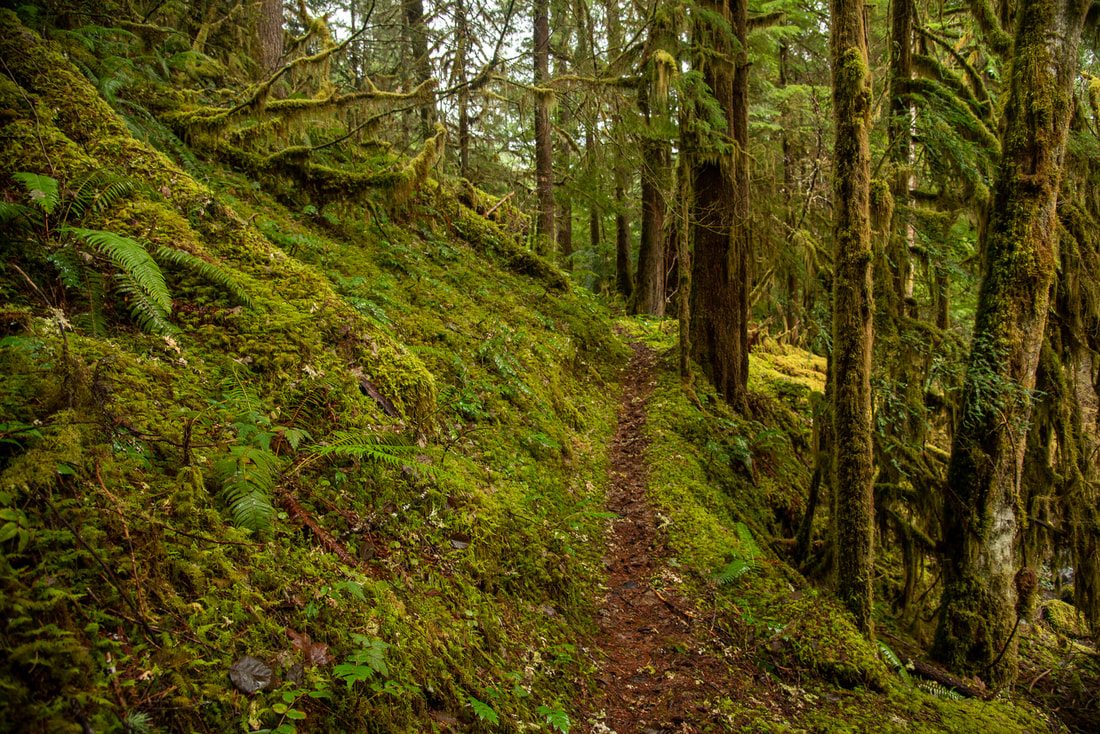
The trail follows the cove which gets smaller until it becomes a stream (Larison Creek). At this point the trail tucks into the forest and you will be in the shade for the remainder of the hike. After hiking for 1.5 miles you will see a primitive campsite to the right and to the left of the trail, and to the left, a trail leading down to Larison Creek. The open meadow by the creek is beautiful and perfect for a picnic if you have younger kids who can't hike very far. This spot is great for hanging out in the spring sunshine and the kids can play with rocks and splash in the water.
Larison Creek Trail
Larison Creek Trail old growth
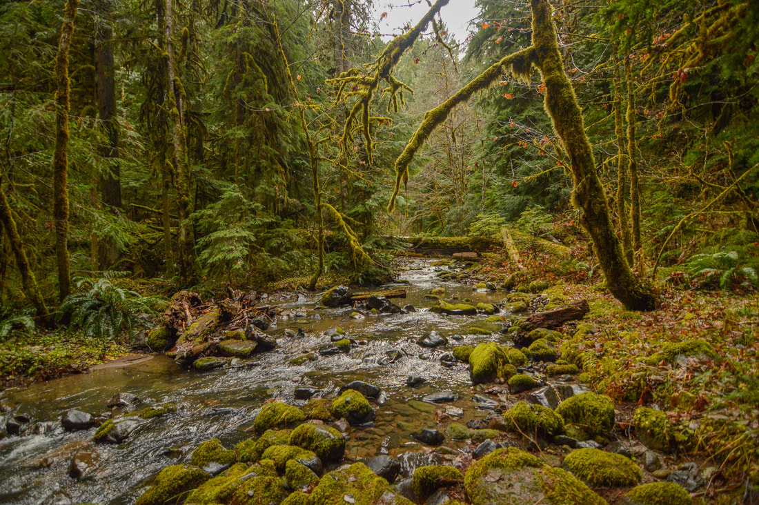
After the primitive campsite, it is about 1.5 miles to what is known to many people as “Small Pool”. There is a 10-foot long area of bedrock that slides into the perfect little pool. In spring, with all of the new green growth on the trees, this spot can be hard to find and it is easy to walk right past it. It is easier to spot in the fall with less vegetation. If you hike to this pool and back the hike is a total of 6 miles. If you would like to hike farther along this beautiful creek, you can continue on the trail.
Small Pool along Larison Creek
(Small Pool)
After “Small Pool” the trail becomes extremely lush and green, due to the canyon getting more narrow and getting much less sun. Here you will find lots of very tall Rhododendron bushes, which generally bloom around mid-June in this climate. For about 1 mile the trail has a 300 ft. elevation climb up and away from the creek, which you then lose again on your way back down to the creek on the other side. You will get some beautiful tight canyon and river views right before getting to where Larison Creek forks. The trail crosses the right arm of the creek via an old log. From here it is another 1.1 miles to where the trail ends at a road 700 ft. up the hill.
Larison Creek Trail covered in moss
Larison Creek
Larison Cove in spring
(Larison Cove in April)
Unless you are mountain biking this trail, or want to go see the road, there is no reason to hike the last 1.1 miles. This extends the hike and makes it 12 miles in length, and there is nothing spectacular that you would be missing. There is a neat spot down by the creek near the fork to enjoy the convergence of the two creeks and to take a little break before turning around.​

Larison Creek Trail is highly recommended to everyone! Because it is also a fairly popular mountain bike trail, this trail is very well maintained and easy to walk on. There is not much elevation gain, and if you are hiking with small children or you are not up for a 6 - 10 mile hike, you can just hike the 1.5 miles in to Larison Cove and enjoy this beautiful area.

Directions​:

​From Eugene 
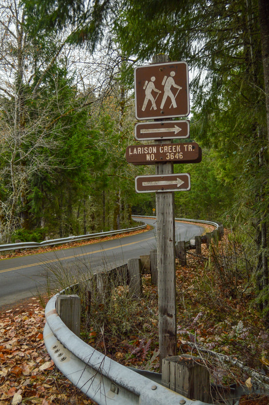
  • Drive OR-58 east towards Oakridge for a total of 35.4 miles. Drive 1.3 miles past the town of Oakridge and then turn right at a sign for Hills Creek Dam. After 0.5 miles turn right onto paved Rd. 21 and follow this windy road uphill for 3.3 miles. The trailhead is on your right, clearly marked by a hiker symbol sign. (Total of 48.6 miles)
From Bend 
  • Drive south on US-97 to Crescent/Gilcrest for a total of 46.9 miles. Turn right onto Crescent Cutoff Rd. for 12 miles and then turn right onto OR-58 west towards Oakridge for 35.6 miles. Between milepost markers 38 and 37 turn left at a sign for Hills Creek Dam. After 0.5 miles turn right onto paved Rd. 21 and follow this windy road uphill for 3.3 miles. The trailhead is on your right, clearly marked by a hiker symbol sign. (Total of 98.9 miles)
From Salem 
  • Total of 110 miles via Eugene.
From Portland 
  • Total of 155 miles via Eugene.
*All pictures are taken by Franziska Weinheimer
*Disclaimer: The trail descriptions, mileage, GPS tracks and difficulty ratings depicted on this website are never 100% accurate. Always hike at your own risk, using your own knowledge, equipment and common sense.  Franziska Weinheimer/Hike Oregon are not responsible if you or anyone in your party gets injured or lost while attempting one of these or any other hikes. 

HIKED HERE RECENTLY? PLEASE LEAVE A TRIP REPORT BELOW:

© Hike Oregon 2022
P.O. Box 41911
​Eugene, OR 97404
Proudly powered by Weebly
  • Home
  • *Store*
  • About the author
  • How to use this site
  • Resources
    • Wildflowers
    • Videos
  • Best Oregon Hikes
    • 20 Epic Oregon Wildflower Hikes
    • Top 10 Oregon Spring Hikes
    • 20 Best Oregon Waterfall Hikes
    • Top 10 Oregon Hikes for Kids
    • 5 Weekend Backpacking Trips in Oregon
    • Top One Night Backpacking Trips in Oregon
    • Top Fall Foliage Hikes In Oregon
    • Top 10 Oregon Summer Hikes
    • Top 10 Swimming Spots In Oregon
    • Top 10 Oregon Fall Hikes
    • Sno-Parks In Central Oregon
    • Top 10 Oregon Winter Hikes
    • Top Low Elevation Winter Hikes
  • Oregon Sno-Parks
    • Maxwell Sno-Park
    • Potato Hill Sno-Park
    • Ray Benson Sno-Park
      • Brandenburg Shelter
    • Santiam Sno-Park
    • Three Creek Sno-Park
    • Virginia Meissner Sno-Park
      • Meissner Shelter Loop
      • Nordeen Shelter
    • Gold Lake Sno-Park
      • Westview Shelter to Eagle Rock Overlook
      • Marilyn Lakes Loop
  • Portland
    • Powell Butte
    • Forest Park
    • Hamilton Mountain
    • Latourell Falls
    • Multnomah/Wahkeena Falls
    • Dog Mountain
    • Coyote Wall
    • Mitchell Point
    • Table Rock
    • Tamanawas Falls
    • Trillium Lake
    • East Zigzag Mountain (members only)
  • Salem
    • Abiqua Falls
    • Silver Falls State Park
    • Marion Lake to Marion Mountain
    • Jefferson Park
  • Sweet Home
    • Crescent Mountain
    • Iron Mountain
    • McDowell Creek Falls
    • Middle Santiam River (members only)
    • Lower Soda Creek Falls (members only)
    • Rooster Rock (members only)
  • McKenzie Bridge/Blue River
    • Macduff Mountain
    • Proxy Falls
    • Clear Lake
    • Sahalie/Koosah Falls
    • Blue Pool
    • Erma Bell Lakes
    • Olallie Mountain
    • Horsepasture Mountain
    • Tidbits Mountain
    • Castle Rock
    • East Fork Trail (members only)
    • Rainbow Falls Overlook (members only)
    • Frissell Point (members only)
    • Chucksney Mountain (members only)
    • Substitute Point (members only)
  • Sisters/Santiam Pass
    • Coffin Mountain
    • Trappers Butte and Scar Mountain
    • Black Butte
    • Tam McArthur Rim
    • Black Crater
    • Scott Mountain
    • Obsidian Trail
    • Three Fingered Jack Loop
    • Square Lake
    • Canyon Creek Meadows
    • Patjens Lakes
    • Craig Lake (members only)
    • Chush Falls (members only)
    • Rockpile Lake (members only)
    • Santiam Lake (members only)
    • Camp Lake (members only)
    • Park Meadow to Golden Lake (members only)
  • Bend/Redmond/LaPine
    • Steins Pillar
    • Chimney Rock
    • Steelhead Falls
    • Tumalo State Park
    • Tumalo Falls
    • Tumalo Mountain
    • No Name Lake
    • Green Lakes
    • Moraine Lake
    • South Sister Summit
    • Muskrat Lake
    • Paulina Peak
    • Peter Skene Ogden Trail (members only)
  • Eugene
    • Ridgeline Trail
    • Mount Pisgah Summit
    • Mount Pisgah Arboretum
    • Shotgun Creek
    • Mount June
    • Lawler
    • Tire Mountain
    • Goodman Creek
    • Brice Creek
    • Trestle Creek Falls
    • Moon Falls
    • Elijah Bristow State Park
    • South Willamette Trail (members only)
    • Eula Ridge (members only)
    • Eagle's Rest (members only)
  • Oakridge
    • Deception Creek
    • North Salmon Creek
    • Grasshopper Ridge
    • Larison Creek
    • Bunchgrass Ridge
    • Salt Creek Falls
    • Waldo Lake Loop
    • South Waldo Loop
    • The Twins
    • Rosary Lakes
    • Fawn Lake
    • Windy Lakes
    • Divide Lake
    • Diamond Peak Summit
    • Cowhorn Mountain
    • Wall Creek Warm Springs (members only)
    • Moon Point (members only)
    • Bobby Lake (members only)
    • Lillian Falls (members only)
    • Middle Fork Willamette Trail (members only)
    • Pool Creek Falls (members only)
    • Dead Mountain (members only)
    • Larison Rock (members only)
    • Eddeeleo Lakes (members only)
    • Waldo Mountain Lookout (members only)
    • Blair Lake to Mule Mountain (members only)
    • Rigdon Lakes loop (members only)
  • Oregon Coast
    • Cascade Head
    • Drift Creek Falls
    • Sweet Creek Falls
    • Alsea Falls
    • Kentucky Falls
    • Marys Peak North Ridge
    • Marys Peak East Ridge
    • Cape Perpetua Loops
    • Hobbit Trail to Heceta Head
    • North Fork Smith River (members only)
    • Cummins Ridge (member's only)
    • Horse Creek (members only)
    • Siltcoos Lake (members only)
    • William Finley Wildlife Refuge (members only)
  • Southern Oregon
    • Fall Creek Falls
    • Watson Falls
    • Wild Rogue Loop
    • Mt. Thielsen
    • The Watchman
    • Mount Scott
    • The Pinnacles
    • Lower Table Rock
    • Pilot Rock
    • Wagner Butte
    • Mt. McLoughlin
    • Lemolo Falls (members only)
    • Fern Falls (members only)
  • Eastern Oregon
    • Painted Cove
    • Mount Howard
    • Anthony Lake Loop
    • Schneider Cabin (members only)
    • Strawberry Lake & Falls (members only)
  • Oregon PCT sections
    • PCT: OR-58 to Charlton Lake
    • PCT: Santiam Pass to Rockpile Lake
  • Tips & Tricks
    • Leave No Trace
    • Top Tips For Hiking With Infants And Toddlers
    • Poison Oak, Ivy and Sumac
    • How to dress for cold weather hikes
    • Hiker Holiday Gift Guide 2019
    • Outdoor Holiday Gift Guide 2018
    • Hiking Holiday Gift Guide 2017
  • Reviews
    • Outdoor Herbivore Backpacking Food Review
    • Osprey Aura AG 65 Backpack review
    • Big Agnes Fly Creek UL2 review
    • REI Quarter Dome 1 review
  • Adventure Stories
    • Hiking The Rae Lakes Loop
    • 110 Miles on the PCT
    • The Loop Around Three Fingered Jack
    • Jefferson Wilderness